
Aberdeen Proving Ground (APG) is a U.S. Army facility located adjacent to Aberdeen, Harford County, Maryland, United States. More than 7,500 civilians and 5,000 military personnel work at APG.
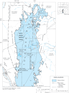
White Sands Missile Range (WSMR) is a military testing area operated by the United States Army. The range was originally established as the White Sands Proving Ground on 9 July 1945. White Sands National Park is located within the range.
Base Realignment and Closure (BRAC) is a process by a United States federal government commission to increase United States Department of Defense efficiency by coordinating the realignment and closure of military installations following the end of the Cold War. More than 350 installations have been closed in five BRAC rounds: 1988, 1991, 1993, 1995, and 2005. These five BRAC rounds constitute a combined savings of $12 billion annually.

Naval Station Great Lakes is the home of the United States Navy's only boot camp, located near North Chicago, in Lake County, Illinois. Important tenant commands include the Recruit Training Command, Training Support Center and Navy Recruiting District Chicago. Naval Station Great Lakes is the largest military installation in Illinois and the largest training station in the Navy. The base has 1,153 buildings situated on 1,628 acres (6.59 km2) and has 69 mi (111 km) of roadway to provide access to the base's facilities. Within the naval service, it has several different nicknames, including "The Quarterdeck of the Navy", or the more derogatory "Great Mistakes". It is also referred to as "second boot camp" while at Training Support Command.

Fort Wingate was a military installation near Gallup, New Mexico. There were two other locations in New Mexico called Fort Wingate: Seboyeta, New Mexico (1849–1862) and San Rafael, New Mexico (1862–1868). The most recent Fort Wingate (1868–1993) was established at the former site of Fort Lyon, on Navajo territory, initially to control and "protect" the large Navajo tribe to its north. The Fort at San Rafael was the staging point for the Navajo deportation known as the Long Walk of the Navajo. From 1870 onward the garrison near Gallup was concerned with Apaches to the south, and through 1890 hundreds of Navajo Scouts were enlisted at the fort.
Tooele Army Depot (TEAD) is a United States Army Joint Munitions Command post in Tooele County, Utah. It serves as a storage site for war reserve and training ammunition. The depot stores, issues, receives, renovates, modifies, maintains and demilitarizes conventional munitions. The depot also serves as the National Inventory Control Point for ammunition peculiar equipment, developing, fabricating, modifying, storing and distributing such equipment to all services and other customers worldwide. TEAD provides base support to Deseret Chemical Depot.

The 2005 Base Realignment and Closure Commission preliminary list was released by the United States Department of Defense on May 13, 2005. It was the fifth Base Realignment and Closure ("BRAC") proposal generated since the process was created in 1988. It recommended closing 22 major United States military bases and the "realignment" of 33 others. On September 15, 2005, President George W. Bush approved the BRAC Commission's recommendations, leaving the fate of the bases in question to the United States Congress. Congress had a maximum of 45 days to reject the proposal by passing a joint resolution of disapproval, or the recommendations automatically enter into effect. Such a resolution was introduced to the House of Representatives on September 23, 2005, by Rep. Ray LaHood (R-IL). The House took up debate of the resolution on October 26, 2005. The resolution failed to pass by a 324-85 margin, thereby enacting the list of recommendations. The Secretary of Defense was required to begin implementing the recommendations by September 15, 2007 and to complete implementation no later than September 15, 2011.

The Defense Supply Center, Columbus (DSCC), is one of three Inventory Control Points of the Defense Logistics Agency. The major organization on base is known as DLA Land and Maritime. Defense Finance and Accounting Service (DFAS) is also a major tenant on base. The base has been affected several times by the United States Base Realignment and Closure program. It is located in the Columbus, Ohio suburb of Whitehall. The DSCC has a historical marker. The base was opened in 1918.

Fort Monmouth is a former installation of the Department of the Army in Monmouth County, New Jersey. The post is surrounded by the communities of Eatontown, Tinton Falls and Oceanport, New Jersey, and is located about five miles (8.0 km) from the Atlantic Ocean. The post covers nearly 1,126 acres (4.56 km2) of land, from the Shrewsbury River on the east, to Route 35 on the west; this area is referred to as 'Main Post'. A separate area to the west includes post housing, a golf course, and additional office and laboratory facilities. A rail line, owned by Conrail, runs through Camp Charles Wood and out to Naval Weapons Station Earle. The post is like a small town, including a Post Exchange (PX), health clinic, gas station and other amenities. Until the September 11, 2001 terrorist attacks the post was open to the public to drive through; after that time, the post was closed to all but authorized personnel. The main road through the fort was reopened to the public in 2017.
Blue Grass Army Depot (BGAD) is a U.S. Army Joint Munitions Command storage facility for conventional munitions and chemical weapons. The facility is located in east central Kentucky, southeast of the cities of Lexington and Richmond, Kentucky. The 14,494-acre (58.66 km2) site, composed mainly of open fields and wooded areas, is used for munitions storage, repair of general supplies, and the disposal of munitions. The installation is used for the storage of conventional explosive munitions as well as assembled chemical weapons. The depot primarily is involved in industrial and related activities associated with the storage and maintenance of conventional and chemical munitions.
Tobyhanna Army Depot, is a logistics center for the United States Department of Defense (DoD), specializing in electronic systems. It is located in Coolbaugh Township, Monroe County, near Tobyhanna, Pennsylvania. Established February 1, 1953, as Tobyhanna Signal Depot, today it is a facility for the repair, upgrade and integration of Command, Control, Computer, Communications, Intelligence, Surveillance, and Reconnaissance (C4ISR) systems for all branches of the Armed Forces.

Fort Richardson is a United States Army installation in the U.S. State of Alaska, adjacent to the city of Anchorage. In 2010, it was merged with nearby Elmendorf Air Force Base to form Joint Base Elmendorf-Richardson.
Letterkenny Army Depot, the Center of Industrial and Technical Excellence (CITE) for Air Defense and Tactical Missile Systems, was established in 1942. The Depot is under the command structure of the U.S. Army Aviation and Missile Command (AMCOM). The facilities at Letterkenny are used to conduct maintenance, modification, storage, and demilitarization operations on tactical missiles and ammunition.

Fort McClellan, originally Camp McClellan, was a United States Army post located adjacent to the city of Anniston, Alabama. During World War II, it was one of the largest U.S. Army installations, training an estimated half-million troops. After the war it became the home of the Military Police Corps, the Chemical Corps and the Women's Army Corps. From 1975 and until it was closed in 1999, Fort McClellan was home of the Military Police Corps and the One Station Unit Training (OSUT) Military Police School. Also after World War II and until it was closed in 1999, it was home of the Chemical Corps School, which trained soldiers in chemical warfare. In 1988, Fort McClellan was used as an alternate training academy for the United States Border Patrol. Before its closure by the Base Realignment and Closure commission (BRAC), the post employed about 10,000 military personnel and about 1,500 civilians. It underwent unexploded ordnance (UXO) clean up from 2003 to 2014. Since 2010, about 3,000 acres of the post's brownfield land have been redeveloped as a mixed-use community.
Fort Hunter Liggett is a United States Army fort in Jolon, California, in southern Monterey County, California. The fort, named in 1941 after General Hunter Liggett, is primarily used as a training facility, where activities such as field maneuvers and live fire exercises are performed. It is roughly 25 miles northwest of Camp Roberts, California.
A proving ground (US) is an installation or reservation in which technology such as weapons, military tactics and automobile prototypes are experimented with or tested. Proving grounds can be operated by government bodies or civilian industries. They are distinct from military training areas which are run by the military and intended for the routine training and exercising of troops across the terrain.
Big Oaks National Wildlife Refuge is a 50,000-acre (202 km2) wildlife refuge operated by the United States Fish and Wildlife Service in southeast Indiana, United States near Madison, Indiana. The refuge is the largest of Indiana's three National Wildlife Refuges, and is located in parts of Ripley, Jefferson, and Jennings counties.

The Forest Glen Annex is a 136-acre (0.55 km2) U.S. Army installation in the Forest Glen Park neighborhood of Silver Spring, Maryland, USA. It is situated between Brookville Road and Linden Lane. Since 1999, the Annex has been the site of the Walter Reed Army Institute of Research (WRAIR) and the Naval Medical Research Center (NMRC), along with smaller units. In addition to the large research laboratories located in the Annex's "Daniel K. Inouye Building", the post includes a commissary, a child care center, and a Fisher House. There are also football and baseball fields, and picnicking facilities. In 2011, in accordance with the most recent Base Realignment and Closure (BRAC) recommendations, the Forest Glen Annex became home to the National Museum of Health and Medicine (NMHM) as well as a "Joint Center of Excellence in Infectious Disease Research." The former Army and Air Force Exchange Service (AAFES) post exchange was repurposed as office space and a new Navy Exchange (NEX) was opened at the nearby Walter Reed National Military Medical Center in Bethesda, Maryland.

Pueblo Depot Activity(PUDA), formerly known as the Pueblo Ordnance Depot and the Pueblo Army Depot, was a U.S. Army ammunition storage and supply facility. Responsibility for the depot fell upon the U.S. Army Ordnance Corps, and the first civilians were hired in 1942 as operations began. The mission quickly expanded to include general supplies as well. It is a 24,202-acre (97.94 km2) site located 14 miles (23 km) east of Pueblo, Colorado. In 1945 they began to receive mass amounts of equipment returning from the combat theaters of World War II. Therefore, the mission expanded yet again to include the maintenance and refurbishing of artillery, fire control, and optical material. In 1951 the depot assumed responsibility to distribute U.S. Air Force ammunition for an eight-state area, as well as storage of strategic and critical materials for the General Services Administration (GSA). They were also tasked to rebuild and provide on-site maintenance support for guided missiles, ensure calibration and maintenance of electronic test equipment and radio-controlled aerial targets. They would also provide specialized training for new Army equipment as needed. In 1952, Rocky Mountain Arsenal in Denver, Colorado transferred chemical agents and chemical munitions to Pueblo Army Depot for secure storage. In 1974 Pueblo Army Depot was redesignated as Pueblo Depot Activity.
The 1988 Base Realignment and Closure Commission preliminary list was released by the United States Department of Defense in 1988 as part of the Base Realignment and Closure Commission. It recommended closing 17 major United States military bases.

