Related Research Articles

Wyoming County is a county located in the U.S. state of Pennsylvania. As of the 2010 census, the population was 28,276. Its county seat is Tunkhannock. It was created in 1842 from part of Luzerne County.

Wyoming is a city in Stark County, Illinois, United States. The population was 1,429 at the 2010 census, up from 1,424 in 2000. It is the headquarters of the Rock Island Trail State Park. Wyoming is part of the Peoria, Illinois Metropolitan Statistical Area. The former CB&Q Railroad depot in town is the Rock Island Trail State Park's headquarters.
Lurgan Township is a township in Franklin County, Pennsylvania, United States. The population was 2,151 at the 2010 census.

Huntington Township is a township in Luzerne County, Pennsylvania, United States. The population was 2,244 at the 2010 census.
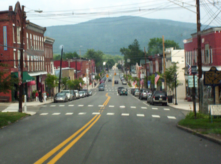
Tunkhannock is a borough in Wyoming County, Pennsylvania, 31 miles (50 km) northwest of Wilkes-Barre. In the past, lumbering was carried on extensively. Today, many residents are employed by the Procter & Gamble plant in nearby Washington Township. As of the 2010 census, the borough population was 1,836. It is the county seat of Wyoming County. Tunkhannock is in the Scranton–Wilkes-Barre–Hazleton, PA Metropolitan Statistical Area.

Windsor is a borough in York County, Pennsylvania, United States. It was established in 1905 and was named after Windsor, England. It was formerly named Windsorville. The population was 1,319 at the 2010 census. In the spring of 2016, the Pennsylvania Department of Conservation and Natural Resources and York County's Marcellus Shale fund provided $350,000 to make improvements at the Windsor baseball field. The project includes a handicap accessible bridge, wetland plants to capture rain runoff, new playground equipment and new bleachers.

Hampton Township is a township in Allegheny County, Pennsylvania, United States. The population was 18,363 at the 2010 census.

The Wyoming Valley is a historic industrialized region of Northeastern Pennsylvania, once famous for fueling the industrial revolution in the United States with its many anthracite coal mines. As a metropolitan area, it is known as the Scranton/Wilkes-Barre metropolitan area, after its principal cities, Scranton and Wilkes-Barre, and is the 101st-largest metropolitan area in the United States and the 4th largest in Pennsylvania. It makes up its own unique physiographic province, the Anthracite Valley, in the geology of Pennsylvania. Greater Pittston makes up the center of the valley. Scranton is the most populated city in the metropolitan area with a population of 77,114. The city of Scranton has grown in population after the 2015 mid term census while Wilkes-Barre has declined in population. Wilkes-Barre is still the second most populated city in the metropolitan area and Hazleton is third. The airports for this area are Wilkes-Barre/Scranton International Airport (Avoca) and the Wilkes-Barre Wyoming Valley Airport.

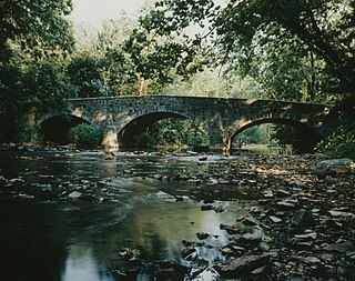
Mehoopany Creek is a tributary of the Susquehanna River in Sullivan and Wyoming counties, Pennsylvania, in the United States. It is approximately 26.8 miles (43.1 km) long. In Sullivan County the creek flows through Colley Township and in Wyoming County it flows through Forkston Township and Mehoopany Township. The stream's watershed has an area of 123 square miles (320 km2). Its major tributaries include Stony Brook and North Fork Mehoopany Creek.
Noxen is a census-designated place located in Noxen Township, Wyoming County in the state of Pennsylvania. The community is located very close to Pennsylvania Route 29. As of the 2010 census the population was 633 residents.
Exchange is an unincorporated community in Montour County, Pennsylvania.
Wyoming is an unincorporated community in Otoe County, Nebraska, United States.

Guilford Road is a historic road north of Savage, Maryland that traverses Anne Arundel and Howard Counties in an area that was first settled by English colonists in the mid-1600s. Today's Guilford road is a series of disconnected segments bisected multiple times by the construction of Maryland Route 32.
Sweet Valley is an unincorporated community in Ross Township, Luzerne County, in the U.S. state of Pennsylvania.
Heathville is an unincorporated community in Jefferson County, in the U.S. state of Pennsylvania.
Ohl is an unincorporated community in Jefferson County, in the U.S. state of Pennsylvania.
Baxter is an unincorporated community in Jefferson County, in the U.S. state of Pennsylvania.
Soldier is an unincorporated community in Jefferson County, in the U.S. state of Pennsylvania.
Lovelton is an unincorporated populated place in North Branch Township, Wyoming County, Pennsylvania, in the United States. It is in the United States Geological Survey quadrangle of Jenningsville.
Little Mehoopany Creek is a tributary of the Susquehanna River in Wyoming County, Pennsylvania, in the United States. It is approximately 8.4 miles (13.5 km) long and flows through Windham Township and Mehoopany Township. The watershed of the creek has an area of 11.3 square miles (29 km2), most of which is forested land and agricultural land. No stream in the watershed is designated as an impaired waterbody. The main rock formation in the watershed is the Catskill Formation and the main soil association is the Wellsboro-Oquaga-Morris.
References
- ↑ U.S. Geological Survey Geographic Names Information System: Jenningsville, Pennsylvania
- ↑ "Wyoming County". Jim Forte Postal History. Retrieved 30 July 2017.
- ↑ History of Luzerne, Lackawanna, and Wyoming Counties, Pa. W.W. Munsell & Company. 1880. p. 537.
- ↑ The National Cyclopædia of American Biography. J. T. White. 1918. p. 196.
Municipalities and communities of Wyoming County, Pennsylvania, United States | ||
|---|---|---|
| Boroughs |  | |
| Townships | ||
| CDPs | ||
| Unincorporated communities | ||
| Ghost town | ||
Coordinates: 41°34′59″N76°08′38″W / 41.58306°N 76.14389°W
| This Wyoming County, Pennsylvania state location article is a stub. You can help Wikipedia by expanding it. |