Related Research Articles
Ross Township is a township in Luzerne County, Pennsylvania, United States. The population was 2,937 at the 2010 census.

Bowman Creek is a tributary of the Susquehanna River in Luzerne County and Wyoming County, in Pennsylvania, in the United States. It is approximately 26 miles (42 km) long and flows through Ross Township and Lake Township in Luzerne County and Noxen Township, Monroe Township, and Eaton Township in Wyoming County. The watershed of the creek has an area of 120 square miles (310 km2). The creek is not designated as an impaired waterbody and its pH is close to neutral, although it has experienced some problems with acid rain. It has low concentrations of dissolved solids like calcium. The creek is relatively small in its upper reaches, but by Noxen, its width is 40 to 60 feet. It is also relatively shallow in many reaches. Rock formations in the watershed include the Catskill Formation, the Huntley Mountain Formation, Burgoon Sandstone, the Mauch Chunk Formation, the Pottsville Group, and the Pocono Formation. Soil associations in the creek's watershed include the Wellsboro-Morris-Oquaga association, the Oquaga-Lackawanna-Arnot association, the Mardin-Bath-Volusia association, and the Wyoming-Pope association.
Wyalusing Creek is a tributary of the Susquehanna River in Susquehanna and Bradford counties, Pennsylvania, in the United States. It is approximately 19.1 miles (30.7 km) long and flows through Rush township in Susquehanna County and Stevens Township, Tuscarora Township, Wyalusing Township, and Wyalusing in Bradford County. The watershed of the creek has an area of 219 square miles (570 km2). It is possible to canoe on a significant portion of the creek.

Sandy Lick Creek is a tributary of Redbank Creek in northwest Pennsylvania in the United States.

Little Fishing Creek is a tributary of Fishing Creek in Sullivan County, Lycoming County, and Columbia County, in Pennsylvania, in the United States. It is approximately 23.5 miles (37.8 km) long and flows through eight townships. The watershed of the creek has an area of 68.1 square miles (176 km2). The creek has six named tributaries, of which the largest are Spruce Run and West Branch Run.

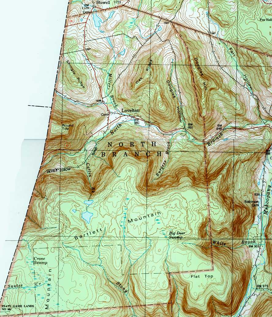
Mehoopany Creek is a tributary of the Susquehanna River in Sullivan and Wyoming counties, Pennsylvania, in the United States. It is approximately 26.8 miles (43.1 km) long. In Sullivan County the creek flows through Colley Township and in Wyoming County it flows through Forkston Township and Mehoopany Township. The stream's watershed has an area of 123 square miles (320 km2). Its major tributaries include Stony Brook and North Fork Mehoopany Creek.
Stony Brook is a tributary of Mehoopany Creek in Wyoming County, Pennsylvania, in the United States. It is approximately 4.3 miles (6.9 km) long and flows through North Branch township and Forkston Township. The brook has a tributary known as Red Brook. Logging was done in the upper reaches of the watershed of Stony Brook in the early 1900s.

Shingle Run is a tributary of West Branch Run in Lycoming County and Columbia County, in Pennsylvania, in the United States. It is approximately 2.5 miles (4.0 km) long and flows through Jordan Township, Lycoming County and Pine Township, Columbia County. Its watershed has an area of 1.63 square miles (4.2 km2) and the stream has various unnamed tributaries. At least one bridge crosses the stream. The stream is inhabited by trout. It is named after nearby sawmills.

Crooked Creek is a tributary of Kitchen Creek in Luzerne County, Pennsylvania, in the United States. It is approximately 1.8 miles (2.9 km) long and flows through Fairmount Township. The watershed of the creek has an area of 1.20 square miles (3.1 km2) and there is one named tributary. The creek is considered to be Class A Wild Trout Waters and a portion of it flows through Ricketts Glen State Park. Wisconsinan Till, Wisconsinan Outwash, and alluvium can be found in its vicinity.

Roaring Run is a tributary of Bowman Creek in Wyoming County, Pennsylvania, in the United States. It is approximately 4.9 miles (7.9 km) long and flows through Forkston Township, Noxen Township, and Monroe Township. It has two named tributaries: Newton Run and South Branch Roaring Run. The watershed of Roaring Run has an area of 11.4 square miles (30 km2). It is designated as a High-Quality Coldwater Fishery and a Migratory Fishery and the stream is Class A Wild Trout Waters. The surficial geology in its vicinity consists of alluvium, alluvial terrace, alluvial fan, bedrock, Wisconsinan Till, and Wisconsinan Ice-Contact Stratified Drift. A bridge carrying Pennsylvania Route 29 crosses the stream.

Billings Mill Brook is a tributary of Tunkhannock Creek in Wyoming County, Pennsylvania, in the United States. It is approximately 3.5 miles (5.6 km) long and flows through Lemon Township and Tunkhannock Township. The watershed of the stream has an area of 12.7 square miles (33 km2). The stream has one named tributary, which is known as Kern Glen Creek. The surficial geology in the vicinity of Billings Mill Brook mainly consists of Wisconsinan Till, alluvium, and several others. A lake known as Lake Carey is in the stream's watershed. A number of bridges have also been constructed over Billings Mill Brook. The stream's watershed is designated as a Coldwater Fishery and a Migratory Fishery.

Trout Brook is a tributary of South Branch Tunkhannock Creek in Lackawanna County and Wyoming County, in Pennsylvania, in the United States. It is approximately 5.0 miles (8.0 km) long and flows through West Abington Township in Lackawanna County and Clinton Township in Wyoming County. The stream has no named tributaries, but it does have ten unnamed tributaries. There are also a number of wetlands in the watershed of the stream. The stream is classified as a Coldwater Fishery. Its watershed occupies portions of three municipalities in Wyoming County and five in Lackawanna County.
North Branch Mehoopany Creek is a tributary of Mehoopany Creek in Bradford County, Sullivan County, and Wyoming County, in Pennsylvania, in the United States. It is approximately 14 miles (23 km) long and flows through Wilmot Township in Bradford County, Colley Township in Sullivan County, and North Branch Township and Forkston Township. The watershed of the creek has an area of 40.0 square miles (104 km2). The creek has eight named direct tributaries, including hollows. In the 1940s and 1950s, the average discharge for September was found to be just 6.8 cubic feet per second (0.19 m3/s), but was found to be over 100 cubic feet per second (2.8 m3/s) for July and August.
Douglas Hollow is a tributary of North Branch Mehoopany Creek in Wyoming County, Pennsylvania, in the United States. It is approximately 1.7 miles (2.7 km) long and flows through North Branch Township. The watershed of the stream has an area of 1.57 square miles (4.1 km2). The stream is classified as a Coldwater Fishery and is inhabited by four fish species, including wild brook trout. Its entire length is within 300 meters (980 ft) of a road and it flows through a mixture of forested and agricultural land.
Burgess Brook is a tributary of North Branch Mehoopany Creek in Wyoming County, Pennsylvania, in the United States. It is approximately 1.2 miles (1.9 km) long and flows through North Branch Township. The watershed of the stream has an area of 1.42 square miles (3.7 km2). The stream is narrow, with a high gradient, and is located in a remote area, mostly far away from any roads. It is designated as Class A Wild Trout Waters and has a large population of brook trout, as well as smaller numbers of brown trout. Three other fish species are also present in the stream.
Miller Brook is a tributary of North Branch Mehoopany Creek in Wyoming County, Pennsylvania, in the United States. It is approximately 2.2 miles (3.5 km) long and flows through North Branch Township. The watershed of the stream has an area of 3.86 square miles (10.0 km2). The stream is not designated as an impaired waterbody. Wild trout naturally reproduce in the stream, and several other fish species have been observed.
Catlin Brook is a tributary of North Branch Mehoopany Creek in Wyoming County, Pennsylvania, in the United States. It is approximately 1.5 miles (2.4 km) long and flows through North Branch Township. The watershed of the stream has an area of 1.16 square miles (3.0 km2). The stream itself is very small and steep, and is known for its extremely inaccessible waterfalls.
Barnes Brook is a tributary of North Branch Mehoopany Creek in Wyoming County and Sullivan County, in Pennsylvania, in the United States. It is approximately 1.8 miles (2.9 km) long and flows through North Branch Township in Wyoming County and Colley Township in Sullivan County. The watershed of the stream has an area of 1.98 square miles (5.1 km2). It is a high-gradient stream that flows mainly through forested lands, and has one named tributary.
Coffee Brook is a tributary of Barnes Brook in Wyoming County and Sullivan County, in Pennsylvania, in the United States. It is approximately 1.1 miles (1.8 km) long and flows through North Branch Township in Wyoming County and Colley Township in Sullivan County. The watershed of the stream has an area of 0.86 square miles (2.2 km2). The stream itself has a high gradient and primarily flows through forested lands. Access is difficult due to a lack of nearby roads and extensive private property signs in the area.
Smith Cabin Run is a tributary of North Branch Mehoopany Creek in Sullivan County, Pennsylvania, in the United States. It is approximately 1.6 miles (2.6 km) long and flows through Colley Township. The watershed of the stream has an area of 1.45 square miles (3.8 km2). The stream has a high gradient and flows primarily through forested land. It has an unnamed pond at its headwaters and a 20-foot (6.1 m) waterfall on an unnamed tributary.
References
- 1 2 3 4 Geographic Names Information System, Feature Detail Report for: Lovelton , retrieved January 6, 2018
- 1 2 United States Geological Survey (1987), northbra.jpg , retrieved January 6, 2018
- 1 2 3 History of Luzerne, Lackawanna, and Wyoming Counties, Pa: With Illustrations and Biographical Sketches of Some of Their Prominent Men and Pioneers, W.W. Munsell & Company, 1880, p. 526, retrieved January 6, 2018
- 1 2 3 4 Sean Billings, Johanna S. Billings (2004), Wyoming County, Arcadia Publishing, pp. 51, 59, ISBN 9780738534916 , retrieved January 6, 2018
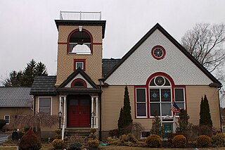
- ↑ "Kid's trout derby planned in Lovelton", Times Leader , March 20, 2016, retrieved January 6, 2018
Municipalities and communities of Wyoming County, Pennsylvania, United States | ||
|---|---|---|
| Boroughs |  | |
| Townships | ||
| CDPs | ||
| Unincorporated communities | ||
| Ghost town | ||
Coordinates: 41°32′21″N76°11′18″W / 41.53917°N 76.18833°W
| | This Wyoming County, Pennsylvania state location article is a stub. You can help Wikipedia by expanding it. |