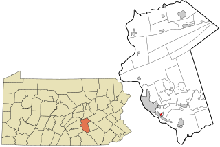
Wyoming County is a county in the Commonwealth of Pennsylvania. It is part of Northeastern Pennsylvania. As of the 2020 census, the population was 26,069. Its county seat is Tunkhannock. It was created in 1842 from part of Luzerne County.

Alba is a borough in Bradford County, Pennsylvania, United States. It is part of Northeastern Pennsylvania. The population was 135 at the 2020 census.

Cherry Township is a township in Butler County, Pennsylvania, United States. The population was 1,106 at the 2010 census.

Slippery Rock Township is a township in Butler County, Pennsylvania, United States. The population was 6,719 at the 2020 census.

Almedia is a census-designated place (CDP) in Columbia County, Pennsylvania, United States. It is part of Northeastern Pennsylvania. The population was 1,078 at the 2010 census. It is part of the Bloomsburg-Berwick micropolitan area.

Mifflinville is an unincorporated community and census-designated place (CDP) in Columbia County, Pennsylvania, United States. It is part of Northeastern Pennsylvania. The population was 1,253 at the 2010 census. It is part of the Bloomsburg-Berwick micropolitan area.

East Berwick is a census-designated place (CDP) in Salem Township, Luzerne County, Pennsylvania, United States. The population was 2,007 at the 2010 census.

Jennerstown is a borough in Somerset County, Pennsylvania, United States. It is part of the Johnstown, Pennsylvania Metropolitan Statistical Area. The population was 679 at the 2020 census. The borough is the home of Jennerstown Speedway. The town was named for Edward Jenner.

Little Meadows is a borough in Susquehanna County, Pennsylvania, United States. The population was 247 at the 2020 census.

Mount Wolf is a borough in York County, Pennsylvania, United States. The population was 1,367 at the 2020 census.

Pennville is a census-designated place (CDP) in York County, Pennsylvania, United States. The population was 1,947 at the 2010 census.
Sheatown is a census-designated place (CDP) in Newport Township, Luzerne County, Pennsylvania, United States. It is adjacent to the west side of the city of Nanticoke. The population of Sheatown was 671 at the 2010 census.

Queens Gate is a census-designated place (CDP) in York County, Pennsylvania, United States. The population was 1,464 at the 2010 census. The area was part of the Tyler Run-Queens Gate CDP at the 2000 census.

Chase is a census-designated place (CDP) in Jackson Township, Luzerne County, Pennsylvania, United States. The CDP population was 978 at the 2010 census.
Pikes Creek is a census-designated place (CDP) in Lake Township, Luzerne County, Pennsylvania, United States. The population was 269 at the 2010 census.
Silkworth is a census-designated place (CDP) in Lehman Township, Luzerne County, Pennsylvania, United States. The population was 820 at the 2010 census.
Enhaut is an unincorporated community and census-designated place (CDP) located in Swatara Township, Dauphin County, Pennsylvania, United States. The community was formerly part of the census-designated place of Bressler-Enhaut-Oberlin, before splitting into three separate CDPs for the 2010 census. As of the 2010 census, the population in Enhaut was 1,007.

Dewart is a census-designated place located in Delaware Township, Northumberland County in the state of Pennsylvania. The community is located very close to the West Branch Susquehanna River along Pennsylvania Route 405 in far northern Northumberland County. As of the 2010 census the population was 1,471 residents.

Montandon is a census-designated place located in West Chillisquaque Township, Northumberland County in the state of Pennsylvania, United States. The community is located near the West Branch Susquehanna River at the intersections of Pennsylvania Routes 147 and 45, roughly halfway between the boroughs of Northumberland and Milton. As of the 2010 census the population was 903 residents.
Park Crest is a census-designated place located in Rush Township in Schuylkill County in the state of Pennsylvania, United States. Park Crest was part of the Grier City-Park Crest CDP for the 2000 census, before splitting into two separate CDPs for the 2010 census, the other being Grier City. The community is located off Interstate 81. As of the 2010 census, the population was 542 residents.