Jerktail, Missouri

Last updated
Jerktail
USA Missouri location map.svg
Red pog.svg
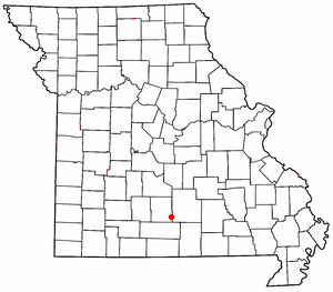
Jerktail
Location within the state of Missouri
Coordinates: 37°25′27″N92°26′13″W / 37.42417°N 92.43694°W / 37.42417; -92.43694 Coordinates: 37°25′27″N92°26′13″W / 37.42417°N 92.43694°W / 37.42417; -92.43694 [1]
Country United States
State Missouri
County Wright
Elevation
[1]
1,306 ft (398 m)
Time zone UTC-6 (Central (CST))
  Summer (DST) UTC-5 (EDT)
GNIS feature ID750505 [1]

Jerktail is an unincorporated community located in northern Wright County, Missouri, United States. [1] The community is approximately two miles west of the Gasconade River and about three miles south of Competition in adjacent Laclede County. [2]

Unincorporated area Region of land not governed by own local government

In law, an unincorporated area is a region of land that is not governed by a local municipal corporation; similarly an unincorporated community is a settlement that is not governed by its own local municipal corporation, but rather is administered as part of larger administrative divisions, such as a township, parish, borough, county, city, canton, state, province or country. Occasionally, municipalities dissolve or disincorporate, which may happen if they become fiscally insolvent, and services become the responsibility of a higher administration. Widespread unincorporated communities and areas are a distinguishing feature of the United States and Canada. In most other countries of the world, there are either no unincorporated areas at all, or these are very rare; typically remote, outlying, sparsely populated or uninhabited areas.

Wright County, Missouri U.S. county in Missouri

Wright County is a county located in the southern portion of the U.S. state of Missouri. As of the 2010 census, the population was 18,815. Its county seat is Hartville. The county was officially organized on January 29, 1841, and is named after Silas Wright, a former Congressman, U.S. Senator and Governor of New York.

Missouri U.S. state in the United States

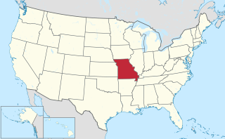
Missouri is a state in the Midwestern United States. With over six million residents, it is the 18th-most populous state of the Union. The largest urban areas are St. Louis, Kansas City, Springfield and Columbia; the capital is Jefferson City. The state is the 21st-most extensive in area. Missouri is bordered by eight states : Iowa to the north, Illinois, Kentucky and Tennessee to the east, Arkansas to the south and Oklahoma, Kansas and Nebraska to the west. In the South are the Ozarks, a forested highland, providing timber, minerals and recreation. The Missouri River, after which the state is named, flows through the center of the state into the Mississippi River, which makes up Missouri's eastern border.

Variant names were "Jerk Tail" and "Mint". [1] A post office called Mint was established in 1889, and remained in operation until 1910. [3] The former name "Mint" was due to the abundance of wild mint bushes near the original town site. [4]

Related Research Articles

Manes, Missouri unincorporated community in Missouri

Manes is an unincorporated community in Wright County, Missouri, United States. It is located on Route 95, approximately 12 miles northeast of Hartville.

Graff, Missouri unincorporated community in eastern Wright County, Missouri, United States

Graff is an unincorporated community in eastern Wright County, Missouri, United States. It is located on Missouri Route 38, 12.5 miles (20.1 km) east-northeast of Hartville.

Grovespring, Missouri unincorporated community in Missouri

Grovespring is an unincorporated community in Wright County, Missouri, United States. It is located on Missouri Route 5, approximately 20 miles (32 km) south of Lebanon, Missouri in neighbouring Laclede County.

Odin is an unincorporated community in Wright County, in the U.S. state of Missouri. The community is located on Missouri Route 38, approximately five miles west of Hartville. It is located at the confluence of Bowman Creek and the Woods Fork of the Gasconade River.

Mountain Grove, Missouri City in Missouri, United States

Mountain Grove is a city in southwestern Texas and southeastern Wright counties in the U.S. state of Missouri, located in the south central section of the state. The population was 4,789 at the 2010 census.

Talmage is an unincorporated community in Wright County, in the U.S. state of Missouri. The community was located just west of Missouri Route E, approximately five miles due east of Hartville and two miles north of the community of Owens. It is on a ridge between Clark and Whetstone creeks at an elevation of 1266 feet.

Astoria is an unincorporated community in northeastern Wright County, in the Ozarks of southern Missouri. The community is located at an elevation of 1227 feet above Beaver Creek adjacent to the Mark Twain National Forest. Manes is approximately four miles west, on Missouri Route 95.

Boyer is an unincorporated community in Wright County, in the U.S. state of Missouri. The community is located on Missouri Route 5, northwest of Hartville.

Duggan is an unincorporated community in Wright County, in the U.S. state of Missouri.

Fuson is an unincorporated community in Wright County, in the U.S. state of Missouri. The community is located on Missouri Route Z, approximately five miles north of Hartville.

Loring is an extinct town in Wright County, in the U.S. state of Missouri. The GNIS classifies it as a populated place. The community is located just east of Missouri Route 5 between Hartville and Grovespring. It is near the headwaters of Steins Creek.

Mingsville is an extinct town in northeastern Wright County, in the U.S. state of Missouri. The GNIS classifies it as a populated place.

New Grove is an extinct town in western Wright County, in the Ozarks of southern Missouri, United States. The GNIS classifies it as a populated place.

Rail, Missouri human settlement in Missouri, United States of America

Rail is an extinct town in east central Wright County, in the Ozarks of southern Missouri, United States. The GNIS classifies it as a populated place. The village was located on the west bank of Beaver Creek, just southeast of the intersection of Missouri routes 38 and 95.

Rayborn is an unincorporated community in eastern Wright County, in the U.S. state of Missouri. Rayborn is located on Missouri Route 38, between Hartville and Graff. The intersection of Route 38 and Missouri Route 95 is approximately 2.5 miles to the east of the town.

Rembert is an extinct town in south central Wright County, in the Ozarks of southern Missouri. The site is approximately two miles west-southwest of Hartville and north of Missouri Route 38 and the Woods Fork of the Gasconade River.

Smittle is an unincorporated community in northwestern Wright County, in the U.S. state of Missouri. The community was located on Missouri Route TT, approximately five miles east of Grovespring and one half mile west of Elk Creek. The historic Mt. Olive School was just north of the village.

St. George is an unincorporated community in central Wright County, in the U.S. state of Missouri. The community is located on St. George Road, just southwest of Missouri Route H and four miles east of Manes. The site is in Hillhouse Hollow, a tributary of the Gasconade River.

Umpire is an unincorporated community in southwestern Wright County, in the U.S. state of Missouri.

Dawson is an unincorporated community in eastern Wright County, Missouri, United States. Dawson is located on Missouri Route 95, approximately nine miles north of Mountain Grove and three miles south of the Route 95 - Missouri Route 38 junction.

References

  1. 1 2 3 4 5 U.S. Geological Survey Geographic Names Information System: Jerktail
  2. Missouri Atlas & Gazetteer, DeLorme, 1998, First edition, p. 53, ISBN   0-89933-224-2
  3. "Post Offices". Jim Forte Postal History. Retrieved 3 January 2017.
  4. "Wright County Place Names, 1928–1945". The State Historical Society of Missouri. Archived from the original on June 24, 2016. Retrieved January 3, 2017.