Jhhirniya

Last updated

Jhhirniya

Jhirniya
village
Madhya Pradesh districts location map big.svg
Red pog.svg
Jhhirniya
India location map.svg
Red pog.svg
Jhhirniya
Coordinates: 23°21′11″N77°14′19″E / 23.3529382°N 77.2387191°E / 23.3529382; 77.2387191 Coordinates: 23°21′11″N77°14′19″E / 23.3529382°N 77.2387191°E / 23.3529382; 77.2387191
Country India
State Madhya Pradesh
District Bhopal
Tehsil Huzur
Elevation
516 m (1,693 ft)
Population
 (2011)
  Total1,100
Time zone UTC+5:30 (IST)
ISO 3166 code MP-IN
2011 census code482349

Jhhirniya is a village in the Bhopal district of Madhya Pradesh, India. It is located in the Huzur tehsil and the Phanda block. [1]

Bhopal district District of Madhya Pradesh in India

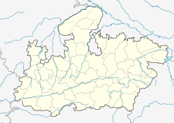
Bhopal District is a district of Madhya Pradesh state in central India. The city of Bhopal serves as its administrative headquarters. The district is part of Bhopal Division.

Madhya Pradesh State in India

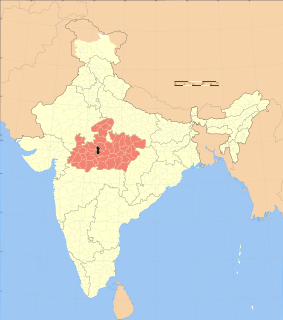
Madhya Pradesh is a state in central India. Its capital is Bhopal, and the largest city is Indore, with Jabalpur, Gwalior, Ujjain and Sagar being the other major cities. Nicknamed the "Heart of India" due to its geographical location, Madhya Pradesh is the second largest Indian state by area and the fifth largest state by population with over 75 million residents. It borders the states of Uttar Pradesh to the northeast, Chhattisgarh to the southeast, Maharashtra to the south, Gujarat to the west, and Rajasthan to the northwest. Its total area is 308,252 km2. Before 2000, when Chhattisgarh was a part of Madhya Pradesh, Madhya Pradesh was the largest state in India and the distance between the two furthest points inside the state, Singoli and Konta, was 1500 km. Konta is presently in Sukma district of Chhattisgarh state.

India Country in South Asia

India is a country in South Asia. It is the seventh-largest country by area, the second-most populous country, and the most populous democracy in the world. Bounded by the Indian Ocean on the south, the Arabian Sea on the southwest, and the Bay of Bengal on the southeast, it shares land borders with Pakistan to the west; China, Nepal, and Bhutan to the north; and Bangladesh and Myanmar to the east. In the Indian Ocean, India is in the vicinity of Sri Lanka and the Maldives; its Andaman and Nicobar Islands share a maritime border with Thailand and Indonesia.

Demographics

According to the 2011 census of India, Jhhirniya has 262 households. The effective literacy rate (i.e. the literacy rate of population excluding children aged 6 and below) is 53.87%. [2]

Demographics (2011 Census) [2]
TotalMaleFemale
Population1100590510
Children aged below 6 years222117105
Scheduled caste 894742
Scheduled tribe 1518566
Literates473303170
Workers (all)564327237
Main workers (total)27225715
Main workers: Cultivators23221
Main workers: Agricultural labourers32302
Main workers: Household industry workers110
Main workers: Other21620412
Marginal workers (total)29270222
Marginal workers: Cultivators1129
Marginal workers: Agricultural labourers30129
Marginal workers: Household industry workers202
Marginal workers: Others24967182
Non-workers536263273

Related Research Articles

Sewaniya village in Madhya Pradesh, India

Sewaniya is a village in the Bhopal district of Madhya Pradesh, India. It is located in the Huzur tehsil and the Phanda block.

Shobhapur Jahej village in Madhya Pradesh, India

Shobhapur Jahej is a village in the Bhopal district of Madhya Pradesh, India. It is located in the Huzur tehsil and the Phanda block.

Kushalpura village in Madhya Pradesh, India

Kushalpura is a village in the Bhopal district of Madhya Pradesh, India. It is located in the Huzur tehsil and the Phanda block.

Bhanpur village in Madhya Pradesh, India

Bhanpur is a village in the Bhopal district of Madhya Pradesh, India. It is located in the Huzur tehsil and the Phanda block.

Bhauri village in Madhya Pradesh, India

Bhauri is a village in the Bhopal district of Madhya Pradesh, India. It is located in the Huzur tehsil and the Phanda block. Bhauri has been included in Bhopal Municipal Corporation in 2015 by Gazette Notification of Government of Madhya Pradesh. The IISER Bhopal is located in Bhauri, beside the Bhopal Bypass Road. School of Planning and Architecture (SPA) Bhopal, an Institute of National Importance under Ministry of Human Resource Development, is located in Bhauri village. SPA is accessed by Neelbad Road from Bhopal Bypass. The road is under construction. Madhya Pradesh Police Academy is also situated in Bhauri village.

Bangrasia village in Madhya Pradesh, India

Bangrasia is a village in the Bhopal district of Madhya Pradesh, India. It is located in the Huzur tehsil and the Phanda block.

Barrai, Huzur village in Madhya Pradesh, India

Barrai is a village in the Bhopal district of Madhya Pradesh, India. It is located in the Huzur tehsil and the Phanda block.

Bhairopur village in Madhya Pradesh, India

Bhairopur is a village in the Bhopal district of Madhya Pradesh, India. It is located in the Huzur tehsil and the Phanda block. A campus of the SCOPE Engineering College is located nearby.

Mendora, Bhopal village in Madhya Pradesh, India

Mendora is a village in the Bhopal district of Madhya Pradesh, India. It is located in the Huzur tehsil and the Phanda block. The Kerwa dam is located here.

Khajuri, Bhopal village in Madhya Pradesh, India

Khajuri is a village in the Bhopal district of Madhya Pradesh, India. It is located in the Huzur tehsil and the Phanda block.

Ratatal village in Madhya Pradesh, India

Ratatal is a village in the Bhopal district of Madhya Pradesh, India. It is located in the Huzur tehsil and the Phanda block.

Pipliya Bajkhan village in Madhya Pradesh, India

Pipliya Bajkhan is a village in the Bhopal district of Madhya Pradesh, India. It is located in the Huzur tehsil and the Phanda block.

Hatai Khedi village in Madhya Pradesh, India

Hatai Khedi is a village in the Bhopal district of Madhya Pradesh, India. It is located in the Huzur tehsil and the Phanda block.

Pipaliya Dhakad village in Madhya Pradesh, India

Pipaliya Dhakad is a village in the Bhopal district of Madhya Pradesh, India. It is located in the Huzur tehsil and the Phanda block.

Phanda Khurd village in Madhya Pradesh, India

Phanda Khurd is a village in the Bhopal district of Madhya Pradesh, India. It is located in the Huzur tehsil and the Phanda block.

Prithvipura village in Madhya Pradesh, India

Prithvipura is a village in the Bhopal district of Madhya Pradesh, India. It is located in the Huzur tehsil and the Phanda block.

Chanderi, Bhopal village in Madhya Pradesh, India

Chanderi is a village in the Bhopal district of Madhya Pradesh, India. It is located in the Huzur tehsil and the Phanda block.

Samarda village in Madhya Pradesh, India

Samarda, also spelled Samardha, is a village in the Bhopal district of Madhya Pradesh, India. It is located in the Huzur tehsil and the Phanda block.

Parewa Kheda village in Madhya Pradesh, India

Parewa Kheda is a village in the Bhopal district of Madhya Pradesh, India. It is located in the Huzur tehsil and the Phanda block.

Intkhedi Sadak village in Madhya Pradesh, India

Intkhedi Sadak is a village in the Bhopal district of Madhya Pradesh, India. It is located in the Huzur tehsil and the Phanda block.

References

  1. "RFP Document for Establishing Operating and Maintaining Lok Seva Kendra" (PDF). E-Governance Society Bhopal District. Archived from the original (PDF) on 4 March 2016. Retrieved 25 July 2015.
  2. 1 2 "District Census Handbook - Bhopal" (PDF). 2011 Census of India . Directorate of Census Operations, Madhya Pradesh. Retrieved 20 July 2015.