Bhopal is the capital city of the Indian state of Madhya Pradesh and the administrative headquarters of both Bhopal district and Bhopal division. It is known as the City of Lakes, due to presence of various natural and artificial lakes near the city boundary. It is also one of the greenest cities in India. It is the 16th largest city in India and 131st in the world. After the formation of Madhya Pradesh, Bhopal was part of the Sehore district. It was bifurcated in 1972 and a new district, Bhopal, was formed. Flourishing around 1707, the city was the capital of the former Bhopal State, a princely state of the British ruled by the Nawabs of Bhopal until India's independence in 1947. India achieved independence on 15 August 1947. Bhopal was one of the last states to sign the ‘Instrument of Accession’. The ruler of Bhopal acceded to the Indian government, and Bhopal became an Indian state on 1 May 1949. Sindhi refugees from Pakistan were accommodated in Bairagarh, a western suburb of Bhopal.

Gwalior is a major city in the central Indian state of Madhya Pradesh; It is known as the City of Music of India having oldest musical gharana in existence. It is a major cultural, industrial, and political centre in Madhya Pradesh. Gwalior is among the seven cities selected for new startup centres under India's growing innovation ecosystem. It lies in northern part of Madhya Pradesh and is one of the Counter-magnet cities. Located 313 kilometres (194 mi) south of New Delhi, the capital city of India and 446 kilometres (277 mi) from Bhopal, the state capital, Gwalior occupies a strategic location in the Gwalior Chambal region of India. The historic city and its fortress have been ruled by several Indian kingdoms. From the Alchon Huns in the 5th century AD to Gurjara Pratihara dynasty in the 8th century AD. It was passed on to Kachchhapaghatas in the 10th century AD. Later It fell into the hands of the Delhi Sultanate in 12th century AD, it was then passed on to the Tomars in the 13th century AD who were the vassal rulers of the Delhi Sultanate. The Mughal Empire conquered the city and its fortress in the 16th century AD. When the Mughal Empire was declining, it fell into the hands of Jat rulers, then to the English in 1730, and last it was passed on to the Scindia Dynasty of Maratha Empire in early 18th century.

Burhanpur is a historical city in the Indian state of Madhya Pradesh. It is the administrative seat of Burhanpur District. It is situated on the north bank of the Tapti River and 512 kilometres (318 mi) northeast of city of Mumbai, 340 kilometres (211 mi) southwest of the state's capital city of Bhopal. The city is a Municipal Corporation.

Mandu or Mandavgad is an ancient city in the present-day Mandav area of the Dhar district. It is located in the Malwa and Nimar region of western Madhya Pradesh, India, at 35 km from Dhar city. In the 11th century, Mandu was the sub division of the Tarangagadh or Taranga kingdom. This fortress town on a rocky outcrop about 100 km (62 mi) from Indore is celebrated for its architecture.
Kurwai is a town and a Nagar Panchayat in Vidisha district in the Indian state of Madhya Pradesh. its also tehsil headquarter and assembly constituency.

Mandla is a city with municipality in Mandla district in the Indian state of Madhya Pradesh. It is the administrative headquarters of Mandla District. The city is situated in a loop of the Narmada River, which surrounds it on three sides, and for 15 miles between Mandla and Ramnagar, Madhya Pradesh the river flows in a deep bed unbroken by rocks. The Narmada is worshiped here, and many ghats have been constructed on the banks of the river. It was a capital of the Gondwana Kingdom who built a palace and a fort, which in the absence of proper care have gone to ruins.
The Nawabs of Bhopal were the Muslim rulers of Bhopal, now part of Madhya Pradesh, India. The nawabs first ruled under the Mughal Empire from 1707 to 1737, under the Maratha Confederacy from 1737 to 1818, then under British rule from 1818 to 1947, and independently thereafter until it was acceded to the Union of India in 1949. The female nawabs of Bhopal held the title Nawab Begum of Bhopal.

Bhopal State was founded by Maharaja of Parmar Rajputs. In the beginning of 18th-century, Bhopal State was converted into an Islamic principality, in the invasion of the Afghan Mughal noble Dost Muhammad Khan. It was a tributary state within the Maratha Confederacy during 18th century (1737–1818), a princely salute state with 19-gun salute in a subsidiary alliance with British India from 1818 to 1947, and an independent state from 1947 to 1949. Islamnagar was founded and served as the State's first capital, which was later shifted to the city of Bhopal.

Bhopal District is a district of Madhya Pradesh state in central India. The city of Bhopal serves as its administrative headquarters. The district is part of Bhopal Division.
Berasia is a town and a nagar palika (municipality) in Bhopal district in the state of Madhya Pradesh, India.

Taj Mahal is a palace built by Sultan Shah Jahan, Begum of Bhopal. It is located beside the Taj-ul-Masajid in Bhopal, India.
Mangalgarh is a panchayat village in the Berasia tehsil of Bhopal district, Madhya Pradesh, India.
The Halali reservoir is a reservoir in Madhya Pradesh state of India, spanning Bhopal, Raisen, and Vidisha districts. It is built on the Halali River, and lies 40 km northwards from the state capital Bhopal.

Dost Mohammad Khan was the founder of Bhopal State in central India. He founded the modern city of Bhopal, the capital of the modern day Madhya Pradesh state.
Events in the year 1707 in India.
Parason is a township located in Bhopal district of Madhya Pradesh, India.

Pathari is a town in Vidisha district, it's also a tehsil headquarter. Many tourist attractions in the Indian state of Madhya Pradesh loceted here.

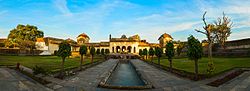
Chaman Mahal is a palace in the Bhopal district of Madhya Pradesh, India. It was built by Afghan Commander Dost Mohammad Khan, who was the ruler of Islamnagar in 1715. It is located 11 km away from Bhopal, capital of Madhya Pradesh. 'Chaman' means garden and hence the palace is also known as Garden palace, having an attractive garden in the middle of palace with multiple fountains. The Chaman Mahal is made of sandstone in Mughal and Malwa style of architecture and has 12 gates at the entrance, with Bengali-influenced drooping eaves. It is a red sandstone structure built by Dost Mohammad Khan. It is also known as Islamnagr fort. It is surrounded by gardens and fountains, and is ornamented with floral motifs. It has charbagh style garden. The ruined palace has a Mughal water garden and a hamam.

Ginnorgarh is a fort in Raisen District, Madhya Pradesh. Located in the Ratapani Tiger Reserve on a rocky summit rising to 700m, Ginnorgarh has two natural water bodies and a fortified enclosure with the remains of several palaces, gatehouses and cisterns.