Jordan Valley Unified Water Plan

Last updated
Banias waterfall, Golan Heights Banias spring1.JPG
Banias waterfall, Golan Heights
Flood waters exiting from the Yarmuk reservoir to the Yarmuk river, 1933 The Palestine Electric Corporation power plant. The P.E.C. Yarmuk reservoir sluice gates. Exit for flood waters from Yarmuk Lake to Yarmuk river-bed. 1927 1933.jpg
Flood waters exiting from the Yarmuk reservoir to the Yarmuk river, 1933
Lake Kinneret, Israel PikiWiki Israel 1363 Lake Kinneret Sea of Galilee Israel knrt.jpg
Lake Kinneret, Israel
National Water Carrier of Israel-en.svg

The Jordan Valley Unified Water Plan, commonly known as the "Johnston Plan", was a plan for the unified water resource development of the Jordan Valley. It was negotiated and developed by United States Special Representative Eric Johnston between 1953 and 1955, and based on an earlier plan commissioned by United Nations Relief and Works Agency for Palestine Refugees in the Near East (UNRWA). Modeled upon the Tennessee Valley Authority's engineered development plan, it was approved by technical water committees of all the regional riparian countries—Israel, Jordan, Lebanon and Syria. [1] Though the plan was rejected by the Arab League, both Israel and Jordan undertook to abide by their allocations under the plan. The US provided funding for Israel's National Water Carrier after receiving assurances from Israel that it would continue to abide by the plan's allocations. [2] Similar funding was provided for Jordan's East Ghor Main Canal project after similar assurances were obtained from Jordan. [3]

Contents

Background

In the late 1930s and mid 1940s, Transjordan and the Zionist Organization commissioned mutually exclusive, competing water resource development studies. The Transjordanian study, performed by Michael G. Ionides, concluded that the naturally available water resources were not sufficient to sustain a Jewish homeland and the destination of Jewish immigrants. The Zionist's study, by the American engineer Walter Clay Lowdermilk concluded similarly, but noted that by diverting water from the Jordan River basin to the Negev for support of agricultural and residential development there, a Jewish state with 4 million new immigrants would be sustainable. [4]

In 1953, Israel began construction of a water carrier to take water from the Sea of Galilee to the populated center and agricultural south of the country, while Jordan concluded an agreement with Syria, known as the Bunger plan, to dam the Yarmouk river near Maqarin, and utilize its waters to irrigate Jordanian territory, before they could flow to the Sea of Galilee. [5] Military clashes ensued, and US President Dwight Eisenhower dispatched ambassador Johnston to the region to work out a plan that would regulate water usage. [6]

CIA Declassified Documents [7]

Banat Yacov Project. 7 February 1956:

I. Next foreseeable crisis date in Arab-Israeli situation comes on 1 March, the "deadline" date which Israelis gave Amb. Johnston last autumn for gaining Arab acceptance of Jordan river valley scheme. After 1 March, Israelis told Johnston, they would feel free to go ahead with unilateral Israeli plan for using Jordan Waters.

II. Bone of contention is so-called Banat Yacov project, which takes its name from bridge crossing Jordan River some 8 mi. north of Lake Tiberias (Sea of Galilee).

III. Question came to UN Security Council shortly after Israelis began work on project over two years ago. (Sep '53).

IV. However, Israelis have made their "postponement" of Banat Yacov completion contingent on implementation of Johnston plan.

V. On 31 Jan, Syrian prime minister Ghazzi delivered aide memoirs to US embassy which implied that Syria would use force to prevent Israelis from resuming work on that part of Banat Yacov canal which lies in "demilitarized zone."

VI. However, Israelis have given intimations recently that "deadline" does not necessarily mean they will resume Banat Yacov work on or immediately after 1 March.

UN Sec. Gen Hammarskjold after visit to Palestine in January told American officials he felt Banat Yacov issue Syria would fight on. he felt Israel wrong if forced this issue and he and Gen. Burns agreed they would take strong stand against unilateral action by Israel at Banat Yacov. [8]

Plan

Eisenhower appointed Eric Johnston as a special ambassador on 16 October 1953, and tasked him with mediating a comprehensive plan for the regional development of the Jordan River system. [9] As a starting point, Johnston used a plan commissioned by UNRWA and performed by the American consulting firm Chas. T. Main, known as the "Main Plan". The Main Plan, published just days before Johnston's appointment, utilized the same principles employed by the Tennessee Valley Authority to optimize the usage of an entire river basin as a single unit. [10]

The plan was based on principles similar to those embodied in the Marshall Plan – reducing the potential for conflict by promoting cooperation and economic stability. [9]

The main features of the plan were:

The initial plan gave preference to in-basin use of the Jordan waters, and ruled out integration of the Litani River in Lebanon. The proposed quotas were: Israel 394 million m³, Jordan 774 million m³, and Syria 45 million m³.

Both sides countered with proposals of their own. Israel demanded the inclusion of the Litani river in the pool of available sources, the use of the Sea of Galilee as the main storage facility, out-of-basin use of the Jordan waters, and the Mediterranean-Dead Sea canal. As well, Israel demanded more than doubling of its allocation, from 394 million m³ annually to 810 million m³.

The Arabs countered with a proposal based on the Ionides, MacDonald and Bunger plans, meaning exclusive in-basin use, and rejecting storage in the Sea of Galilee. As well, they demanded recognition of Lebanon as a riparian state, while excluding the Litani from the plan. Their proposed quota allocations were: Israel 200 million m³, Jordan 861 million m³, Syria 132 million m³ and Lebanon 35 million m³ per year.

Negotiations ensued, and gradually the differences were eliminated. Israel dropped the request to integrate the Litani, and the Arabs dropped their objection to out-of-basin use of waters. Ultimately the unified plan proposed the following allocations, by source:

Source Lebanon Syria Jordan Israel
Hasbani 35
Banias 20
Jordan (main stream)22100375
Yarmouk 9037725
Side wadis243
Total35132720400

The Plan was accepted by the technical committees from both Israel and the Arab League. A discussion in the Knesset in July 1955 ended without a vote. The Arab Experts Committee approved the plan in September 1955 and referred it for final approval to the Arab League Council. On 11 October 1955, the Council voted not to ratify the plan, due to the League's opposition to formal recognition of Israel. However, the Arab League committed itself to adhere to the technical details without providing official approval. [9]

Later developments

After the Suez Crisis in 1956, however, Arab attitudes hardened considerably, [12] and the Arab League, with the exception of Jordan, now actively opposed the Johnston plan, arguing that any plan to strengthen the Israeli economy only increased the potential threat from Israel. [13] Regardless, both Jordan and Israel undertook to operate within their allocations, and two major successful projects were completed – the Israeli National Water Carrier and Jordan's East Ghor Main Canal (now known as the King Abdullah Canal). Both projects were partially funded by the United States, after Israel and Jordan provided assurances they would abide by their allocations. In 1965, President Nasser assured the American undersecretary of state, Philip Talbot, that the Arabs would not exceed the water quotas prescribed by the Johnston plan. [qt 1] At this point, the other Arab states resolved to reduce the operation of Israel's National Water Carrier by diverting the headwaters of the Jordan, leading to a series of military clashes which would help precipitate the 1967 Six-Day War. [9] [14]

Related Research Articles

<span class="mw-page-title-main">Galilee</span> Large region mainly located in northern Israel

Galilee is a region located in northern Israel and southern Lebanon. Galilee traditionally refers to the mountainous part, divided into Upper Galilee and Lower Galilee.

<span class="mw-page-title-main">Jordan River</span> River in West Asia which flows to the Dead Sea

The Jordan River or River Jordan, also known as Nahr Al-Sharieat, is a 251-kilometre-long (156 mi) river in the Middle East that flows roughly north to south through the Sea of Galilee and on to the Dead Sea. Jordan and the Golan Heights border the river to the east, while the West Bank and Israel lie to its west. Both Jordan and the West Bank take their names from the river.

<span class="mw-page-title-main">Sea of Galilee</span> Freshwater lake in Israel

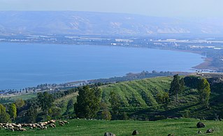
The Sea of Galilee, also called Lake Tiberias or Kinneret, is a freshwater lake in Israel. It is the lowest freshwater lake on Earth and the second-lowest lake in the world, at levels between 215 metres (705 ft) and 209 metres (686 ft) below sea level. It is approximately 53 km (33 mi) in circumference, about 21 km (13 mi) long, and 13 km (8.1 mi) wide. Its area is 166.7 km2 (64.4 sq mi) at its fullest, and its maximum depth is approximately 43 metres (141 ft). The lake is fed partly by underground springs, but its main source is the Jordan River, which flows through it from north to south and exits the lake at the Degania Dam.

<span class="mw-page-title-main">Golani Brigade</span> Infantry brigade of the Israel Defense Forces

The 1st "Golani" Brigade is an Israeli military infantry brigade that is subordinated to the 36th Division and traditionally associated with the Northern Command. It is one of the five infantry brigades of the regular Israel Defense Forces (IDF). Its symbol is a green olive tree against a yellow background, with its soldiers wearing a brown beret. It is one of the most highly decorated infantry units in the IDF. The brigade consists of five battalions, including two which it kept from its inception, one transferred from the Givati Brigade (51st).

<span class="mw-page-title-main">National Water Carrier of Israel</span> Israeli cross country water supply network

The National Water Carrier of Israel is the largest water project in Israel, completed in 1964. Its main purpose is to transfer water from the Sea of Galilee in the north of the country to the highly populated center and arid south and to enable efficient use of water and regulation of the water supply in the country. Up to 72,000 cubic meters of water can flow through the carrier each hour, totalling 1.7 million cubic meters in a day.

<span class="mw-page-title-main">Yarmouk River</span> River in Western Asia

The Yarmuk River, is the largest tributary of the Jordan River. It runs in Jordan, Syria and Israel, and drains much of the Hauran plateau. Its main tributaries are the wadis of 'Allan and Ruqqad from the north, Ehreir and Zeizun from the east. Although it is narrow and shallow throughout its course, at its mouth it is nearly as wide as the Jordan, measuring thirty feet in breadth and five in depth. The once celebrated Matthew Bridge used to cross the Yarmuk at its confluence with the Jordan.

<span class="mw-page-title-main">Red Sea–Dead Sea Water Conveyance</span> Planned water pipeline in Jordan

The Red Sea–Dead Sea Conveyance (RSDSC), sometimes called the Two Seas Canal, was a planned pipeline to run from the coastal city of Aqaba by the Red Sea to the Lisan area in the Dead Sea. Its abandonment was reported in June 2021.

<span class="mw-page-title-main">Hasbani River</span> River in the Levant

The Hasbani River or Snir Stream, is the major tributary of the Jordan River. Local natives in the mid-19th century knew the river as the Upper Jordan.

<span class="mw-page-title-main">Golan Heights</span> Syrian territory occupied by Israel since 1967

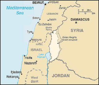
The Golan Heights, or simply the Golan, is a region in the Levant spanning about 1,800 km2 (690 sq mi). The region defined as the Golan Heights differs between disciplines: as a geological and biogeographical region, the term refers to a basaltic plateau bordered by the Yarmouk River in the south, the Sea of Galilee and Hula Valley in the west, the Anti-Lebanon with Mount Hermon in the north and Wadi Raqqad in the east. As a geopolitical region, it refers to the border region captured from Syria by Israel during the Six-Day War of 1967; the territory has been occupied by the latter since then and was subject to a de facto Israeli annexation in 1981. This region includes the western two-thirds of the geological Golan Heights and the Israeli-occupied part of Mount Hermon.

<span class="mw-page-title-main">Jordan Valley</span> Rift valley in Israel, Palestine and Jordan

The Jordan Valley forms part of the larger Jordan Rift Valley. Unlike most other river valleys, the term "Jordan Valley" often applies just to the lower course of the Jordan River, from the spot where it exits the Sea of Galilee in the north, to the end of its course where it flows into the Dead Sea in the south. In a wider sense, the term may also cover the Dead Sea basin and the Arabah valley, which is the rift valley segment beyond the Dead Sea and ending at Aqaba/Eilat, 155 km (96 mi) farther south.

<span class="mw-page-title-main">Headwater Diversion Plan (Jordan River)</span> Arab League plan to divert sources of the Jordan River away from Israel

The Headwater Diversion Plan was an Arab League plan to divert two of the three sources of the Jordan River, and prevent them from flowing into the Sea of Galilee, in order to thwart Israel's plans to use the water of the Hasbani and Banias in its National Water Carrier project for out-of-Basin irrigation. The plan was approved by the Arab League in 1964 but Israel prevented the project's development by conducting airstrikes in Syrian territory in April 1967.

<span class="mw-page-title-main">Water politics in the Middle East</span>

Water politics in the Middle East deals with control of the water resources of the Middle East, an arid region where issues of the use, supply, control, and allocation of water are of central economic importance. Politically contested watersheds include the Tigris–Euphrates river system which drains to the south-east through Iraq into the Persian Gulf, the Nile basin which drains northward through Egypt into the eastern Mediterranean Sea, and the Jordan River basin which flows into the Dead Sea, a land-locked and highly saline sea bordered by Jordan to the east and Israel to the west.

<span class="mw-page-title-main">Battles of the Kinarot Valley</span> Part of the 1948 Arab–Israeli War

The Battles of the Kinarot Valley, is a collective name for a series of military engagements between the Haganah and the Syrian army during the 1948 Arab–Israeli War, fought between 15–22 May 1948 in the Kinarot Valley. It includes two main sites: the Battle of Degania–Samakh (Tzemah), and battles near Masada–Sha'ar HaGolan. The engagements were part of the battles of the Jordan Valley, which also saw fighting against Transjordan in the area of Gesher.

Water politics in the Jordan River basin refers to political issues of water within the Jordan River drainage basin, including competing claims and water usage, and issues of riparian rights of surface water along transnational rivers, as well as the availability and usage of ground water. Water resources in the region are scarce, and these issues directly affect the five political subdivisions located within and bordering the basin, which were created since the collapse, during World War I, of the former single controlling entity, the Ottoman Empire. Because of the scarcity of water and a unique political context, issues of both supply and usage outside the physical limits of the basin have been included historically.

<span class="mw-page-title-main">King Abdullah Canal</span> Largest irrigation canal system in Jordan

The King Abdullah Canal is the largest irrigation canal system in Jordan and runs parallel to the east bank of the Jordan River. It was previously known as the East Ghor Main Canal and renamed in 1987 after Abdullah I of Jordan.

Water supply and sanitation in Jordan is characterized by severe water scarcity, which has been exacerbated by forced immigration as a result of the 1948 Arab–Israeli War, the Six-Day War in 1967, the Gulf War of 1990, the Iraq War of 2003 and the Syrian Civil War since 2011. Jordan is considered one of the ten most water scarce countries in the world. High population growth, the depletion of groundwater reserves and the impacts of climate change are likely to aggravate the situation in the future.

The War over Water, also the Battle over Water, was a series of confrontations between Israel and its Arab neighbors from November 1964 to May 1967 over control of water sources in the Jordan River drainage basin.

<span class="mw-page-title-main">Al-Wehda Dam</span> Dam in Syria/Jordan

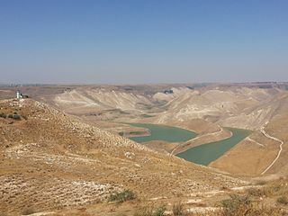
The Al-Wehda Dam, formerly known as Maqarin Dam, is a 110 m (360 ft) roller-compacted concrete gravity dam on the Yarmouk River on the border between Syria and Jordan. It can hold up to 115,000,000 m3 (93,000 acre⋅ft) of water and is designed to provide Jordan with water for both human consumption and agriculture. Water from the reservoir is diverted through a diversion weir at Addassiyah downstream of the Al-Wehda dam to the King Abdullah Canal where it is mixed with other freshwater sources. Some of the water from the canal is then pumped to Amman to be used as drinking water, after being treated in the Zai water treatment plant. The discharge of effluents from adjacent agricultural lands has caused algae growth and eutrophication especially in spring. Construction was funded by the Arab Fund for Economic and Social Development (80%), the Abu Dhabi Development Fund (10%) and the Government of Jordan (10%). In February 2004 King Abdullah II of Jordan and Syrian President Bashar al-Assad launched the construction of the dam. Turkey's Ozaltin Company constructed 60 per cent of the dam, while the remaining 40 per cent were carried out by Marwan Alkurdi Company and the National Company for Roads and Bridges.

Water conflict in the Middle East and North Africa (MENA) primarily deals with three major river basins: the Jordan River Basin, the Tigris-Euphrates River Basin, and the Nile River Basin. The MENA region covers roughly 11.1 million square km. There are three major deserts in the MENA region:

The Jordan Valley Authority (JVA) is a government agency in Jordan tasked with carrying out socioeconomic development of Jordan's side of the Jordan Valley. The agency was established in 1977. It was a successor to the Jordanian Valley Authority, the Jordan River Tributaries Regional Cooperation and several other government departments related to the Jordan Valley. The JVA became responsible for water supply to Jordan's urban areas and agriculture. The JVA however did also play a role in land distribution as in the year of its founding a law established that all developed agricultural land could only be sold to the JVA.

References

  1. The UNRWA commissioned a plan for the development of the Jordan River; this became widely known as "The Johnston plan". The plan was modelled on the Tennessee Valley Authority development plan for the development of the Jordan River as a single unit. Greg Shapland, (1997) Rivers of Discord: International Water Disputes in the Middle East, C. Hurst & Co. Publishers, ISBN   1-85065-214-7 p 14
  2. Sosland, Jeffrey (2007) Cooperating Rivals: The Riparian Politics of the Jordan River Basin, SUNY Press, ISBN   0-7914-7201-9 p 70
  3. Water Resources in Jordan, Munther J. Haddadin, editor, RFF Press, 2006
  4. Water Resources in Jordan, Munther J. Haddadin, pp. 237–238, Resources for the Future, 2006
  5. Water Resources in Jordan, Munther J. Haddadin, p. 239, Resources for the Future, 2006
  6. Water Resources in Jordan, Munther J. Haddadin, p. 32, Resources for the Future, 2006
  7. "BANAT YACOV". cia.gov/library. February 7, 1956. Archived from the original on January 23, 2017. Retrieved December 12, 2016.
  8. "BANAT YACOV, NSC Briefing" (PDF). CIA Declassified Document.: 5. Archived from the original (PDF) on January 23, 2017 via CIA Library.
  9. 1 2 3 4 Masahiro Murakami, Managing Water for Peace in the Middle East: Alternative Strategies , Appendix C: "Historical review of the political riparian issues in the development of the Jordan River and basin management," United Nations University Press, 1995
  10. The UNRWA commissioned a plan for the development of the Jordan River; this became widely known as "The Johnston plan". The plan was modelled on the Tennessee Valley Authority development plan for the development of the Jordan River as a single unit. Greg Shapland, (1997) Rivers of Discord: International Water Disputes in the Middle East. C. Hurst & Co. Publishers, ISBN   1-85065-214-7 p 14
  11. Managing water for peace in the Middle East
  12. Shlaim, Avi (2000): The Iron Wall, Penguin Books, pp. 186–187, ISBN   0-14-028870-8
  13. Shlaim pp. 230–231.
  14. Shlaim, p. 235.

Quotes

  1. Gat, Moshe (2003). Britain and the Conflict in the Middle East, 1964–1967: The Coming of the Six-Day War. Praeger Publishers. p. 101. ISBN   978-0-275-97514-2 . Retrieved 2023-06-24. Nasser, too, assured the American undersecretary of state, Philip Talbot, that the Arabs would not exceed the water quotas prescribed by the Johnson[ sic ] Plan.