
The Chu is a river in Northern Kyrgyzstan and Southern Kazakhstan. Of its total length of 1,067 kilometres (663 mi), the first 115 kilometres are in Kyrgyzstan, then for 221 kilometres the river is the border between Kyrgyzstan and Kazakhstan and the last 731 kilometres are in Kazakhstan. It is one of the longest rivers in Kyrgyzstan and in Kazakhstan. It has a drainage basin of 62,500 square kilometres (24,100 sq mi).

Jalal-Abad Region is a region (oblast) of Kyrgyzstan. Its capital is the city of the same name, Jalal-Abad. It is surrounded by Talas Region, Chüy Region, Naryn Region, Osh Region, and Uzbekistan. Jalal-Abad Region was established on 21 November 1939. On 27 January 1959 it became a part of Osh Region, but regained its old status as a region on 14 December 1990. Its total area is 32,418 km2 (12,517 sq mi). The resident population of the region was 1,260,617 as of January 2021. The region has a sizeable Uzbek minority.

The Naryn rises in the Tian Shan mountains in Kyrgyzstan, Central Asia, flowing west through the Fergana Valley into Uzbekistan. Here it merges with the Kara Darya to form the Syr Darya. It is 807 kilometres (501 mi) long and its basin area is 59,100 square kilometres (22,800 sq mi). It has an annual flow of 13.7 cubic kilometres (11,100,000 acre⋅ft).
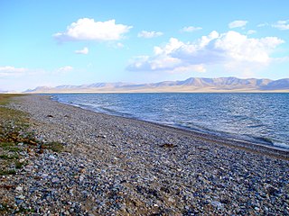
Song-Köl is an alpine lake in northern Naryn Region, Kyrgyzstan. It lies at an altitude of 3016 m, and has an area of about 270 km2 and volume of 2.64 km3. The lake's maximum length is 29 km, breadth about 18 km, and the deepest point is 13.2 m. It is the second largest lake in Kyrgyzstan after Issyk-Kul, and the largest fresh water lake in Kyrgyzstan.

The Aksu River is a transboundary river in the Xinjiang province in China and Ak-Suu District of Issyk-Kul Province of Kyrgyzstan. Its upper section in Kyrgyzstan is known as the Saryjaz River or Sarydzhaz River. The middle section, between the Kyrgyz-Chinese border and the confluence with the Toshkan, is called Kumarik River. The total length of the river is 282 kilometres (175 mi), of which 197 kilometres (122 mi) are in Kyrgyzstan. It has a drainage basin of 12,900 square kilometres (5,000 sq mi) in Kyrgyzstan. The Aksu is the only one of the Tarim's source rivers to run throughout the year.

The Toshkan is a river in the Tien Shan mountains in the border area between China and Kyrgyzstan. It is 345 kilometres (214 mi) long, and has a drainage basin of 8,270 square kilometres (3,190 sq mi) in Kyrgyzstan. The Toshkan has its sources in the At-Bashy Range and Kakshaal Too south of the Kyrgyzstani city of Naryn. In its uppermost course, upstream of the confluences with the rivers Müdürum and Kökkyya, it is called Aksay; from these confluences to the border with China, it is called Kakshaal. It then flows towards the east and into the Xinjiang province of China. It continues east, running parallel to the Tien Shan mountains, until its confluence with the Aksu River near the city Aksu. The Toshkan is the largest tributary of the Aksu.

Ala-Köl is a rock-dammed lake in the Terskey Alatau mountain range in the Ak-Suu District of the Issyk-Kul Region in Kyrgyzstan. It lies at an altitude of 3,532 m (11,588 ft). It is 2.8 km (1.7 mi) long and 600–700 m (2,000–2,300 ft) wide. Its area is 1.5 km2 (0.58 sq mi).
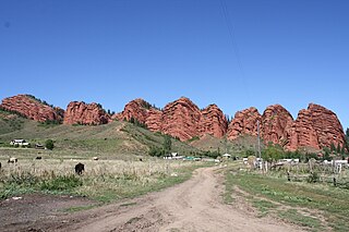
Jeti-Ögüz is a district of Issyk-Kul Region in north-eastern Kyrgyzstan. Its seat lies at Kyzyl-Suu. Its area is 14,499 square kilometres (5,598 sq mi), and its resident population was 93,392 in 2021. It comprises much of the eastern end of the Terskey Ala-Too Range.
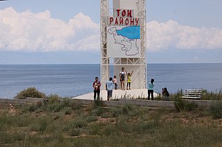
Tong is a district of Issyk-Kul Region in north-eastern Kyrgyzstan. The seat lies at Bökönbaev. Its area is 7,230 square kilometres (2,790 sq mi), and its resident population was 53,401 in 2021. Tong District borders Issyk-Kul District to the north-west, Jeti-Ögüz District to the south and south-east, Kochkor District to the south-west, Naryn District to the south, Kemin District to the north-west, and Issyk Kul - to the north.

Tüp is a district of Issyk-Kul Region in north-eastern Kyrgyzstan. The seat lies at Tüp. Its area is 2,121 square kilometres (819 sq mi), and its resident population was 65,169 in 2021. It borders Issyk-Kul District to the west, Ak-Suu District to the east and south-east, Kazakhstan to the north, and Issyk Kul to the south.

Issyk-Kul District is a district of Issyk-Kul Region in north-eastern Kyrgyzstan. The seat lies at Cholpon-Ata. Its area is 3,603 square kilometres (1,391 sq mi), and its resident population was 84,876 in 2021.
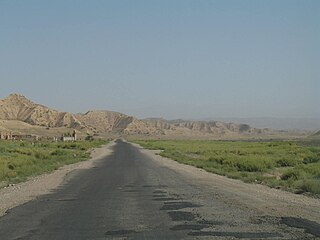
Aksy is a district of Jalal-Abad Region in western Kyrgyzstan. The seat lies at Kerben. Its area is 4,578 km2 (1,768 sq mi), and its resident population was 137,103 in 2021.
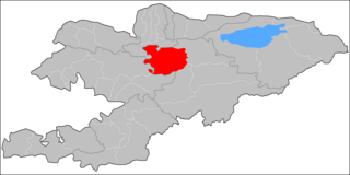
Jumgal is a district of Naryn Region in central Kyrgyzstan. The administrative seat lies at Chaek. Its area is 4,803 square kilometres (1,854 sq mi), and its resident population was 44,866 in 2021. It is a mountainous district. Its main rivers are the Kökömeren and its tributaries Jumgal, Suusamyr and Batysh Karakol.

The Karatal-Japyryk Nature Reserve is a nature reserve in Naryn Region of Kyrgyzstan. Established in 1994, it currently covers 36,393 hectares. It was established with a purpose of conservation of unique nature complexes, protection of rare and threatened species of flora and fauna of Central Tien-Shan, and maintain regional environmental balance.
The Tüp is a river in Tüp District and Ak-Suu District of Issyk-Kul Region of Kyrgyzstan. It rises on north slopes of Teskey Ala-Too Range, takes in several tributaries from the Kungey Alatau and flows into lake Issyk-Kul. With its length of 120 km (75 mi) the Tüp is the longest river of the Issyk-Kul basin. The basin area is 1,180 square kilometres (460 sq mi), the second largest of the rivers entering Issyk-Kul.
The Engilchek is a river in Ak-Suu District of Issyk-Kul Region of eastern Kyrgyzstan. It drains the Engilchek Glacier in the Central Tian Shan Mountains. It is a left tributary of the river Saryjaz. It is 62 kilometres (39 mi) long, has a drainage basin of 1,739 square kilometres (671 sq mi), and its annual average flow rate is 30.0 m3/s (1,060 cu ft/s). The only populated place on its banks is the mining village Engilchek, near its confluence with the Saryjaz.
The Kara-Balta is a transboundary river in Jayyl District of Chüy Region in northern Kyrgyzstan and in Shu District of Jambyl Region in southern Kazakhstan. It rises on north slopes of Kyrgyz Ala-Too, passes through the Sosnovka Gorge, flowing through the Chüy Valley from south to north. The river discharge in Ak-Suu, itself a tributary of the Chu, in Kazakhstan. The Kara-Balta river is 133 kilometres (83 mi) long, and has a drainage basin of 577 square kilometres (223 sq mi). Its average annual discharge is 5.25 m3/s (185 cu ft/s). The catchment area contains small glaciers covering an area of 8 square kilometres (3.1 sq mi) and small lakes with an area of 2.22 square kilometres (0.86 sq mi). It flows through the settlements Sosnovka, Kara-Balta and Stavropolovka.
Karakol Nature Park is a national park in Ak-Suu District of Issyk-Kul Region of Kyrgyzstan established in April 1997. The purpose of the park is conservation of the unique nature complexes, forests, and flora and fauna of special ecological and aesthetic value for beneficial combination of natural and cultural landscapes and their use for recreational, cultural and educational purposes. It covers 38,095 ha. The park is located 6 km from the regional center Karakol and 336 km from Bishkek.

The At-Bashy Range is a mountain range in the south part of the internal Tien-Shan. The range is located in At-Bashy District of the Naryn Region in Kyrgyzstan. The length of the range is 140 km (87 mi) and the width of the range is 30 km (19 mi). The highest parts of the At-Bashy Range, with elevations of more than 4,500 m (14,800 ft), are in its middle part while lower elevated parts, below 4,000 m (13,000 ft), are in the west and in the east. The average height is around 4,280 m (14,040 ft) with the highest point of 4,786 m (15,702 ft).


