
Voyageurs National Park is a national park of the United States in northern Minnesota established in 1975. It is located near the city of International Falls. The park's name commemorates the voyageurs—French-Canadian fur traders who were the first European settlers to frequently travel through the area. Notable for its outstanding water resources, the park is popular with canoeists, kayakers, other boaters, and fishermen. The Kabetogama Peninsula, which lies entirely within the park and makes up most of its land area, is accessible only by boat. To the east of the park lies the Boundary Waters Canoe Area Wilderness.

Scenic State Park is a Minnesota state park near Bigfork in Itasca County. It encompasses 3,936 acres (1,593 ha) of virgin pine forests that surround Sandwick Lake and Coon Lake. It also includes portions of Lake of the Isles, Tell Lake, Cedar Lake, and Pine Lake. Established in 1921, the Ojibwe tribe had previously used the area for hunting. The park has places for camping, hiking, swimming, fishing, and canoeing.

Black Hawk State Park is a state park in Sac County, Iowa, United States, in the town of Lake View. The park includes land, campgrounds, trails, game preserves, historic structures, and the waters of Black Hawk Lake. Also it is home to the Lake View Water Carnival. This event is held the third full weekend in July every year, and includes many family-friendly activities including a Water Parade. Three sections of the park were listed on the National Register of Historic Places in 1991.

The Saddlehorn Caretaker's House and Garage, also known as the Stone House, the Rock House, and the Superintendent's Quarters is a house and asset listed as part of the National Register of Historic Places located in the Colorado National Monument.

This is a list of the National Register of Historic Places listings in Itasca County, Minnesota. It is intended to be a complete list of the properties and districts on the National Register of Historic Places in Itasca County, Minnesota, United States. The locations of National Register properties and districts for which the latitude and longitude coordinates are included below, may be seen in an online map.

The Rand Ranger Station is a Bureau of Land Management compound consisting of eight historic buildings located in the Rogue River-Siskiyou National Forest in southwest Oregon. It was built by the United States Forest Service and the Civilian Conservation Corps as a district ranger station for the Galice Ranger District. The ranger station property was transferred to the Bureau of Land Management in 1970. Today, the ranger station office serves as a visitor center. The Rand Ranger Station is listed on the National Register of Historic Places.

The historical buildings and structures of Zion National Park represent a variety of buildings, interpretive structures, signs and infrastructure associated with the National Park Service's operations in Zion National Park, Utah. Structures vary in size and scale from the Zion Lodge to road culverts and curbs, nearly all of which were designed using native materials and regional construction techniques in an adapted version of the National Park Service Rustic style. A number of the larger structures were designed by Gilbert Stanley Underwood, while many of the smaller structures were designed or coordinated with the National Park Service Branch of Plans and Designs. The bulk of the historic structures date to the 1920s and 1930s. Most of the structures of the 1930s were built using Civilian Conservation Corps labor.
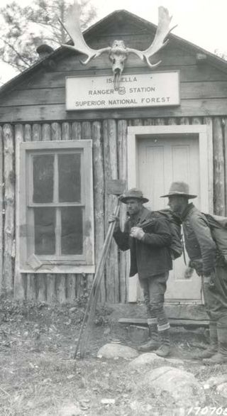
The Isabella Ranger Station is a complex of 21 buildings in Stony River Township, Minnesota, United States, near the town of Isabella. It is located on Minnesota State Highway 1 about one mile east of Isabella. The complex is listed on the National Register of Historic Places for its association with New Deal federal relief construction.
This is a list of the National Register of Historic Places listings in Voyageurs National Park.

The Wind Cave National Park Administrative and Utility Area Historic District comprises the central portion of Wind Cave National Park in South Dakota. The district centers on the historic entrance to Wind Cave, which is surrounded by park administrative and interpretive structures, most of which were built by the Civilian Conservation Corps in the 1930s.
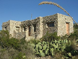
The Caverns Historic District comprises the central developed area of Carlsbad Caverns National Park. The complex was built between the early 1920s and 1942, initially in Pueblo Revival style, and later in New Mexico Territorial Revival style in the area around the natural entrance to Carlsbad Caverns. The earlier structures are built of local limestone, the later buildings in adobe. Thirteen buildings in the district are considered contributing structures. Buildings built between 1940 and 1942 were constructed with labor provided by the Civilian Conservation Corps.

Canelo Ranger Station, also known as Canelo Work Station, is a historic ranger station in the Coronado National Forest, within Santa Cruz County of southern Arizona. It is located in the ghost town of Canelo, within a small valley between the Canelo Hills on the west and the northern Huachuca Mountains on the east.

The Columbine Work Station in Coronado National Forest near Safford, Arizona was built in 1935 by the Civilian Conservation Corps (CCC). The complex is a representative example of a Depression-era Forest Service administrative center. The station is on a high point of the Pinaleño Mountains in forested land. The main residence is in the Forest Service bungalow style. The barn is unique, not designed to a standard Forest Service prototype.

The Lowell Ranger Station compound is in the Coronado National Forest of southern Arizona, United States. It is located in Pima County, near Tucson.
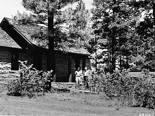
The Moqui Ranger Station in Kaibab National Forest near Tusayan, Arizona, also known as Tusayan Ranger Station, was built in 1939 by the Civilian Conservation Corps (CCC). It was listed on the National Register of Historic Places in 1993 for its architecture, which includes Bungalow architecture, Rustic architecture, vernacular and other styling. It was designed by the USDA Forest Service. The listing includes institutional housing and government office space in six contributing buildings and one other contributing structure over 2 acres (0.81 ha) In addition to CCC labor, workers from the Works Progress Administration (WPA) may have also been involved in the ranger station construction. The station replaced the old Hull Tank Ranger Station.
Architects of the National Park Service are the architects and landscape architects who were employed by the National Park Service (NPS) starting in 1918 to design buildings, structures, roads, trails and other features in the United States National Parks. Many of their works are listed on the National Register of Historic Places, and a number have also been designated as National Historic Landmarks.
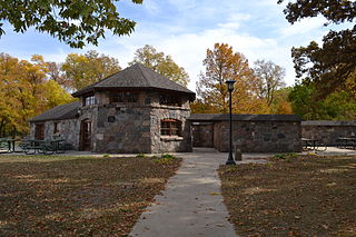
Beeds Lake State Park is located northwest of Hampton, Iowa, United States. It was listed has a historic district on the National Register of Historic Places as Beeds Lake State Park, Civilian Conservation Corps Area in 1990. At the time of its nomination it contained 21 resources, which included one contributing building, 15 contributing structures, and five non-contributing structures. The 319-acre (129 ha) park surrounds a 99-acre (40 ha) reservoir. It features hiking trails, boating, fishing, swimming, camping, picnic areas and shelters, lodges and concessions.

The Marcell Ranger Station is a historic United States Forest Service ranger station in Marcell Township, Minnesota. It was built from 1934 to 1935 to serve as the headquarters for the Marcell District of Chippewa National Forest. It was listed as a historic district on the National Register of Historic Places in 1994 for having state-level significance in the themes of architecture, conservation, and politics/government. It was nominated for its associations with the expansion and development of Chippewa National Forest during the New Deal, for being a well-preserved example of that era's Forest Service administrative facilities, and for its fine National Park Service rustic architecture. Marcell Ranger Station was closed in 2001 and the property was converted into a vacation rental known as Marcell Lodge. A 1963 office adjacent to Minnesota State Highway 38 was turned into the Edge of the Wilderness Discovery Center, a visitor center for the Edge of the Wilderness Scenic Byway.
The Adolph Levin Cottage is a historic vacation property on Kabetogama Lake in St. Louis County, Minnesota, United States. It contains a log cabin built in 1937 for two friends, Dr. Adolph Levin and George Plager. A metal water tank and the surrounding landscape are also contributing historic features. It is now preserved within Voyageurs National Park as an example of the early tourism and recreational properties in the area. In 2011 the property was listed on the National Register of Historic Places for its significance in the themes of architecture and entertainment/recreation. It was nominated for being a representative early-20th-century lake retreat, and for the rustic architecture and traditional Finnish construction of the cabin.
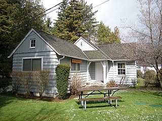
The North Bend Ranger Station is a collection of buildings operated by the USDA Forest Service in the Mount Baker-Snoqualmie National Forest. Constructed by the Civilian Conservation Corps (CCC) in 1936, it was added to the National Register of Historic Places in 1991. The multiple buildings indicate the expansion of Forest Service responsibilities from custodial supervision to extensive resource management. North Bend Ranger Station is considered historic both for its distinctive rustic architecture and for its association with the federal New Deal programs.


