
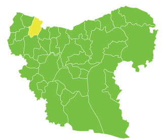
Qaṭma is a village in northwestern Syria, within Afrin District. It is also within Afrin Canton, "de facto" autonomous since January 2014. It lies northeast of Afrin and west of Azaz. According to the Syria Central Bureau of Statistics, Qaṭma had a population of 1,215 in the 2004 census. On March 7, 2018, the town came under the control of the Syrian National Army.
Mayer is a town in northern Syria, administratively part of the A'zaz District of Aleppo Governorate, located northwest of Aleppo. Nearby localities include Kafr Naya to the northeast and Nubl to the west. According to the Syria Central Bureau of Statistics, Mayer had a population of 4,772 in the 2004 census.
Tell Jabin is a town in northern Syria, administratively part of the A'zaz District of Aleppo Governorate, located north of Aleppo. Nearby localities include Tell Rifaat and Kafr Naya to the north, Mare' to the northeast, Bayanoun, Mayer and al-Zahraa to the west. According to the Syria Central Bureau of Statistics, Tell Jabin had a population of 2,579 in the 2004 census.
Kaljibrin is a town in northern Syria, administratively part of the A'zaz District of Aleppo Governorate, located northeast of Aleppo. Nearby localities include Menagh to the west, Kafr Kalbin and A'zaz to the northwest, Jarez to northeast, Mare' to the southeast and Tell Rifaat to the southwest. According to the Syria Central Bureau of Statistics, Kaljibrin had a population of 3,291 in the 2004 census.
Jarez is a village in northern Syria, administratively part of the A'zaz District of Aleppo Governorate, located north of Aleppo. Nearby localities include A'zaz to the west, Kaljibrin to the southwest and Mare' to the southeast. According to the Syria Central Bureau of Statistics, Jarez had a population of 945 in the 2004 census. German traveler Martin Hartmann listed the village as Turkish in late 19th century. The village is inhabited by Turkmen.
Sharran, also known as Sharranli, is a village in northern Syria, administratively part of the Aleppo Governorate, located northwest of Aleppo near the Turkish border. Nearby localities include Azaz and Qatma to the east and Afrin to the south. According to the Syria Central Bureau of Statistics (CBS), Sharran had a population of 2,596 in the 2004 census. The town is also the administrative center of the Sharran nahiyah of the Afrin District consisting of 35 villages with a combined population of 13,632. On March 6, 2018, the town came under the control of the Syrian National Army.
Kafr Safra is a village in northern Syria, administratively part of the Afrin District of the Aleppo Governorate, located northwest of Aleppo. Nearby localities include Shaykh al-Hadid to the north, Qarah Bash to the east and Jindires to the south. According to the Syria Central Bureau of Statistics (CBS), Kafr Safra had a population of 2,150 in the 2004 census.
Dudiyan is a village in northern Aleppo Governorate, northwestern Syria. About 45 kilometres (28 mi) northeast of the city of Aleppo and just 4 km (2.5 mi) south of Syria's border with Turkey, it is administratively part of Nahiya Akhtarin of Azaz District. Nearby localities include Baraghida 7 km (4.3 mi) to the west and Tat Hims 9 km (5.6 mi) to the east. In the 2004 census, Dudiyan had a population of 1,164.Traveler Martin Hartmann noted the village as a Turkmen village in late 19th century.
Baraghida is a village in northern Aleppo Governorate, northwestern Syria. Located halfway between Azaz and al-Rai, some 45 kilometres (28 mi) north of the city of Aleppo and 4 km (2.5 mi) south of the border to the Turkish province of Kilis. The village administratively belongs to Nahiya Sawran in Azaz District. Nearby localities include Kafr Ghan 3 km (1.9 mi) to the west, Dudiyan 7 km (4.3 mi) to the east and Sawran 8 km (5.0 mi) to the south.
Bel is a village in northern Aleppo Governorate, northwestern Syria. Located halfway between Azaz and al-Rai, some 40 kilometres (25 mi) north of the city of Aleppo and 7 km (4.3 mi) south of the border to the Turkish province of Kilis, the village administratively belongs to Nahiya Sawran in Azaz District. Nearby localities include Sawran 4 km (2.5 mi) to the southeast and Kafr Ghan 4 km (2.5 mi) to the north.
Zayzafun, also known as Ikadah, is a village in the northern Aleppo countryside, Aleppo Governorate, northwestern Syria. Located on the Queiq Plain, between Azaz and Al-Rai, the village is some 45 kilometres (28 mi) north of the city of Aleppo, and just 1 km (0.62 mi) south of the border with the Turkish Province of Kilis.
Kafr Shoush is a village in northern Aleppo Governorate, northwestern Syria. It is located between Azaz and Al-Rai on the Queiq Plain, some 45 kilometres (28 mi) north of the city of Aleppo, and 2 km (1.2 mi) south of the border with the Turkish province of Kilis.
Kafr Burayshah, also referred to as Kafr Barja or Kefer Parcha, is a village in northern Aleppo Governorate, northwestern Syria. It is located on the Queiq Plain, 10 kilometres (6.2 mi) northeast of Azaz, 45 km (28 mi) north of the city of Aleppo, and 3 km (1.9 mi) south of the border with the Turkish province of Kilis.
Shamarikh is a village in northern Aleppo Governorate, northwestern Syria. It is located on the Queiq Plain, 9 kilometres (5.6 mi) northeast of Azaz, 45 km (28 mi) north of the city of Aleppo, and 2.5 km (1.6 mi) south of the border with the Turkish province of Kilis.
Tatiyah is a village in northern Aleppo Governorate, northwestern Syria. It is located on the Queiq Plain, 8 kilometres (5.0 mi) northeast of Azaz, 45 km (28 mi) north of the city of Aleppo, and 3.5 km (2.2 mi) south of the border with the Turkish province of Kilis.
Tal'ar Gharbi is a village in northern Aleppo Governorate, northwestern Syria. It is located on the Queiq Plain, between Akhtarin and Al-Rai, and about 45 kilometres (28 mi) northeast of the city of Aleppo.
Tal'ar Sharqi is a village in northern Aleppo Governorate, northwestern Syria. It is located on the Queiq Plain, between Akhtarin and al-Rai, and about 45 kilometres (28 mi) northeast of the city of Aleppo.
Kadrish is a village in northern Aleppo Governorate, northwestern Syria. It is located on the Queiq Plain, between Sawran and al-Rai, about 40 kilometres (25 mi) northeast of the city of Aleppo, and 8 km (5.0 mi) south of the border to the Turkish province of Kilis. The village is inhabited by Turkmen. Traveler Martin Hartmann noted the village as a Turkmen settlement in late 19th century.
Tall Battal, also spelled Til Betal or Tal Bital, is a village in northern Aleppo Governorate, northwestern Syria. Situated in the northern Aqil mountains, bordering the Queiq Plain to the west, it is located halfway between al-Rai and al-Bab, about 40 kilometres (25 mi) northeast of the city of Aleppo, and 15 km (9.3 mi) south of the border to the Turkish province of Kilis.
Qar Kalbin is a village in northern Aleppo Governorate, northwestern Syria. Situated on the eastern edge of the Queiq Plain, bordering the northern Aqil mountains, it is located 6 kilometres (3.7 mi) east of Akhtarin, some 35 km (22 mi) northeast of the city of Aleppo, and 15 km (9.3 mi) south of the border to the Turkish province of Kilis.


