Azaz is a city in northwest Syria, roughly 20 miles north-northwest of Aleppo. According to the Syria Central Bureau of Statistics (CBS), Azaz had a population of 31,623 at the 2004 census. As of 2015, its inhabitants were almost entirely Sunni Muslims, mostly Arabs but also some Kurds and Turkmen.

Al-Bab is a city, de jure administratively belonging to the Aleppo Governorate of the Syrian Arab Republic. As of December 2016, the city is under the control of pro-Turkish militias, as part of the Turkish occupation of northern Syria. Al-Bab is located 40 kilometres (25 mi) northeast of Aleppo, 30 kilometres (19 mi) south of the Turkish border, and has an area of 30 square kilometres. Al-Bab has an altitude of 471 metres. According to the Central Bureau of Statistics (CBS), it had a population of 63,069 in 2004. The population has surged to about 100,000 during the Syrian Civil War. Prior to the Syrian Civil War, al-Bab's inhabitants were composed of a Sunni Arab majority, and a Kurdish minority outside the city center.

Jarabulus is a Syrian city administratively belonging to Aleppo Governorate, under the de facto control of the Syrian Opposition. Jarabulus lies on the western bank of the Euphrates and north of Lake Assad, just south of the Syria–Turkey border and the Turkish town of Karkamış. In the 2004 census, the city had a population of 11,570. The population has increased significantly during the Syrian civil war.
Ma'arrat Misrin is a small city in northwestern Syria, administratively part of Idlib Governorate. Ma'arrat Misrin lies an elevation of 338 metres (1,109 ft). It is located 50 kilometers southwest of Aleppo and 40 kilometers north of Ma'arrat al-Numan and 12 kilometers from Sarmin. Nearby localities include Kafr Yahmul to the north, Zardana and Maarrat al-Ikhwan to the northeast, Taftanaz to the east, Ta'um, Binnish, al-Fu'ah and Kafriya to the southeast, Idlib to the south, and Hafasraja to the southwest.
Atarib, also known as Atharib or Athareb, is a town in western Aleppo countryside, Aleppo Governorate, Syria. Located 25 kilometres west of the city of Aleppo and 25 km (16 mi) southeast of Reyhanlı in Turkish-administered Hatay Province, it is the regional center of Atarib District. In the 2004 census, the town of Atarib had a population of 10,657.

Tell Rifaat is a city in northern Aleppo Governorate, northwestern Syria. Located roughly 40 kilometres (25 mi) north of Aleppo, the city is the administrative center of Nahiya Tell Rifaat. Nearby localities include Azaz to the north, Mare' to the east, Kafr Naya to the south, Deir Jmal and Oqayba to the southwest and Ibbin Samaan to the west. In the 2004 census, Tell Rifaat had a population of 20,514.

Sawran, also spelled Suran, Souran or Sawwaran, is a town in northern Aleppo Governorate, northwestern Syria. Located 22 kilometres (14 mi) north of the city of Aleppo, it is the administrative centre of Nahiya Sawran in Azaz District. Nearby localities include A'zaz and Kafra to the west, Ihtaimlat and Dabiq to the east and Mare' to the south. In the 2004 census, Sawran had a population of 6,988. The town is mainly inhabited by Turkmens.
Mare', also spelled Marea, is a town in northern Aleppo Governorate, northwestern Syria. It is the largest town and administrative centre of the Mare' nahiyah in the Azaz District. Located some 25 kilometers north of the city of Aleppo, the town has a population of 16,904 as per the 2004 census. Nearby localities include Shaykh Issa and Tell Rifaat to the west, A'zaz to the northwest, Dabiq to the northeast, al-Bab to the southeast, and Maarat Umm Hawsh and Herbel to the south.
Kafr Naya is a town in northern Aleppo Governorate, northwestern Syria. Located north of Aleppo, the town is administratively part of Nahiya Tell Rifaat in A'zaz District. Nearby localities include Mayer to the southwest. In the 2004 census, Kafr Naya had a population of 5,647. The village is inhabited by Turkmen.
Deir Jmal is a town in northern Aleppo Governorate, northwestern Syria. Located north of Aleppo, it is administratively part of Nahiya Tell Rifaat in A'zaz District. Nearby localities include Tell Rifaat and Mare' to the east, A'zaz to the north, Mayer and al-Zahraa to the south. In the 2004 census, Deir Jamal had a population of 4,287.
Al-Muslimiyah, commonly known as Mouslimié, is a village in northern Syria, administratively part of the Mount Simeon District of the Aleppo Governorate, located 16 kilometers (9.9 mi) north of Aleppo. Nearby localities include Tell Qarah and Fafin to the north, Ratyan to the northwest, Huraytan to the southwest, the Bustan al-Basha and Sheikh Maqsoud neighborhoods of Aleppo to the south and Kafr Saghir to the southeast. According to the Syria Central Bureau of Statistics (CBS), al-Muslimiyah had a population of 5,916 in the 2004 census.
Qabasin is a town located northeast of the city of Al-Bab in northern Syria. It is administratively part of the Al-Bab nahiya in the Al-Bab District of the Aleppo Governorate. 11,382 people lived in the town in 2004. A nearby town is Arima, to the north-east. The town is inhabited by Turkmen and Kurds.
Arima, also spelled Orayma or Arimah, is a town and seat of a subdistrict (nahiya) in Al-Bab District, located 20 kilometers (12 mi) northeast of the city of al-Bab and 65 kilometers (40 mi) northeast of Aleppo in northern Syria. In the 2004 census, it had a population of 2,839. The town of Qabasin is also to the south-west, and closer than Al-Bab. Manbij city is to the north-east. In course of the Syrian Civil War, the town repeatedly changed hands. As of 2020, it was under dual control of the Syrian government and the Autonomous Administration of North and East Syria (AANES).

Al-Khafsah, also spelled Khafsa, is a village located 77 kilometers (48 mi) east of Aleppo in northern Syria. In the 2004 census, it had a population of 5,393.
Maran is a town in northern Syria, in the west of the Al-Bab District of Aleppo Governorate, about halfway between the cities of Al-Bab and Aleppo. On 22 January 2017, Maran was captured by Government forces.
Al-Rai, is a small town in northern Aleppo Governorate, northern Syria. With 4,609 inhabitants, as per the 2004 census, al-Rai is the administrative center of the sparsely populated Nahiya al-Rai. Located on the Istanbul-Baghdad Railway and close to the Turkish border, right across Elbeyli, it is however a strategically important village. The town of Akhtarin, some 15 kilometers (9.3 mi) to the southwest. Larger towns are Azaz, some 35 kilometers (22 mi) to the west, and Jarablus and Manbij, both some 45 kilometers (28 mi) to the east.
Haji Kusa is a village in northern Aleppo Governorate, northern Syria. It is located in a sparsely populated area, some 18 km (11 mi) east of al-Rai, 22 km (14 mi) northeast of al-Bab and 27 km (17 mi) west of Manbij. Administratively part of Nahiya al-Rai in al-Bab District, the village is inhabited by Turkmen and had a population of 1,011 as per the 2004 census. On 12 November 2016, Haji Kusa was captured by the Syrian National Army from ISIS.
Tell Rahal is a village located 25 km (16 mi) northeast of the city of Aleppo in northern-central Aleppo Governorate, northwestern Syria. It is administratively part of Nahiya al-Bab in al-Bab District. The village had a population of 2,866 as per the 2004 census.
al-Burj, also spelled Borj, is a village in northern Aleppo Governorate, northwestern Syria. Situated in the northern Aqil mountains, bordering the Queiq Plain to the west, it is located between al-Rai and al-Bab, some 40 kilometres (25 mi) northeast of the city of Aleppo, and 12 km (7.5 mi) south of the border to the Turkish province of Kilis. On 7 November 2016, Al Burj was captured by the Syrian National Army from ISIS.
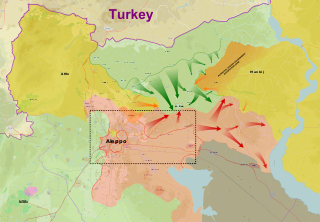
The Battle of al-Bab was a battle for the city of al-Bab in the Aleppo Governorate that included a military offensive launched by Syrian rebel groups and the Turkish Armed Forces north of al-Bab, a separate Syrian Democratic Forces (SDF) offensive east and west of the city, and another Syrian Army offensive from the south of the city. The northern Turkish-led forces intended to capture al-Bab from the Islamic State of Iraq and the Levant (ISIL), as part of the Turkish military intervention in Syria. By the end of the battle, the Turkish-led forces had captured al-Bab, Qabasin, and Bizaah, while the Syrian Army captured Tadef and other areas further south, with the SDF making gains further to the east and the west.


