Solwezi is a town in Zambia. It is the provincial capital of the mineral-rich North-Western Province. Solwezi is also the administrative capital of Solwezi District, one of the eleven districts in the North-Western Province.

The Luangwa River is one of the major tributaries of the Zambezi River, and one of the four biggest rivers of Zambia. The river generally floods in the rainy season and then falls considerably in the dry season. It is one of the biggest unaltered rivers in Southern Africa and the 52,000 square kilometres (20,000 sq mi) that make up the surrounding valley are home to abundant wildlife.

Chipata is a city and administrative centre of the Eastern Province of Zambia and Chipata District. It was declared the 5th city of the country, after Lusaka, Ndola, Kitwe and Livingstone, by President Edgar Lungu on 24 February 2017. The city has undergone rapid economic and infrastructure growth in the years, leading up to city status.
Mufulira is a town in the Copperbelt Province of Zambia. Mufulira means "Place of Abundance and Peace". The town developed around the Mufulira Copper Mine in the 1930s. The town also serves as the administrative capital of Mufulira District.
Mongu is the capital of Western Province in Zambia and was the capital of the formerly-named province and historic state of Barotseland. Its population is 179,585, and it is also the headquarters of Mongu District. Mongu is the home of the Litunga, King of the Lozi people.
Mwinilunga is a town in the North-Western Province of Zambia. It is the headquarters of Mwinilunga District, one of the province's eleven districts.

Kalabo is an urban centre and the seat of Kalabo District, in the Western Province of Zambia.
Kaoma is a town in Zambia. It is the headquarters of Kaoma District in the Western Province and is located on the M9 Road.

Choma is a town that serves as the capital of the Southern Province of Zambia. It is also the capital of Choma District, one of the 15 administrative districts in the province.

Kenneth Kaunda International Airport is an international airport located in Chongwe District, off the Great East Road, approximately 27 kilometres (17 mi) northeast of the city centre of Lusaka, the capital and largest city of Zambia. The airport has a capacity of 6 million and is the largest in Zambia, serving as a hub for its region. The airport serves as a hub for Zambia Airways, Proflight Zambia, Royal Zambian Airlines, and Mahogany Air.
Chipata Airport is an airport serving Chipata, a city in the Eastern Province of Zambia.
Chinhoyi, previously known as Sinoia during the colonial era, is a city in central northern Zimbabwe in the Makonde District. It has a population of 90,800 and is primarily a college town, although it was originally founded as an Italian group settlement scheme. The nearby Chinhoyi Caves and national park are a popular attraction.
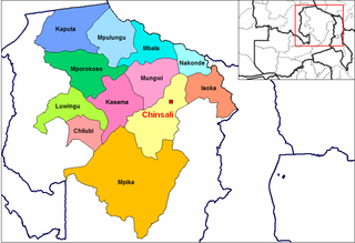
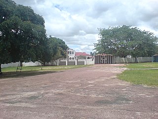
Chinsali is a town in Zambia, which is both the district headquarters of Chinsali District and provincial headquarters of Muchinga Province.
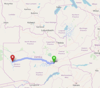
The Lusaka–Mongu Road of Zambia runs 580 km from the capital, Lusaka, to Mongu, capital of the Western Province. It connects that province to the rest of the country, as well as being one of two routes to the south-west extremity of North-Western Province. It also serves as the main highway of the western half of Central Province. The entire route from Lusaka to Mongu is designated as the M9 road.

Kajjansi Airfield is an airfield serving Kajjansi, a town in the Central Region of Uganda.
Lusaka City Airport is a military airport serving Lusaka, Zambia. It is used by the Zambian Air Force and the government, while international and commercial traffic is served by Kenneth Kaunda International Airport.
Chelston, also Chelstone or Chakunkula, is a neighborhood in Zambia's capital city, Lusaka. Before the 1960s Chelstone was an separate town until it was annexed into the greater city of Lusaka.
Nakonde is a town in the Muchinga Province of Zambia, on the border with Tanzania. It is at the northern end of Zambia's Great North Road. It is the principal commercial and political headquarters of Nakonde District and the district headquarters are located here.
Pader Airfield is an airfield serving Pader and Patongo, two towns, 33 kilometres (21 mi) apart, in the south-eastern part of Pader District, in the Northern Region of Uganda.
Mwami is a town in the Eastern Province of Zambia. The town lies at the international border with Malawi, adjacent to the Malawian city of Mchinji.
