Kaleo | |
|---|---|
 Kaleo | |
| Coordinates: 10°10′25″N02°32′31″W / 10.17361°N 2.54194°W | |
| Country | |
| Region | Upper West Region |
| District | Nadowli-Kaleo District |
| Elevation | 1,030 ft (314 m) |
| Time zone | GMT |
| • Summer (DST) | GMT |
Kaleo | |
|---|---|
| Kaleo | |
| Coordinates: 10°10′25″N02°32′31″W / 10.17361°N 2.54194°W | |
| Country | |
| Region | Upper West Region |
| District | Nadowli-Kaleo District |
| Elevation | 1,030 ft (314 m) |
| Time zone | GMT |
| • Summer (DST) | GMT |
The town is located in Nadowli-Kaleo District, in the Upper West Region of Ghana, close to the border with Burkina Faso. [2] Kaleo is located about 27.5 kilometres (17 mi) southeast of the town of Nadowli, the district headquarters. [3] This is approximately 18.5 kilometres (11 mi) northwest of the city of Wa, the capital of Ghana's Upper West Region. [4] Kaleo is located approximately 714 kilometres (444 mi) northwest of Accra the capital and largest city of Ghana. [5] The geographical coordinates of Kaleo, Ghana are:10°10'25.0"N, 2°32'31.0"W (Latitude:10.173611; Longitude:-2.541944). [2] The town sits at an average elevation of 314 metres (1,030 ft) above mean sea level. [1]
Kaleo is the location of Kaleo Solar Power Station. The power station, which was developed in phases, saw the completion of phase one, with capacity of 13 MW, in 2022. Phase two is expected to come online in 2023 and add another 15 MW to the power station's generation capacity, for a total of 28 MW. The solar farm was developed and is owned by the Volta River Authority. [6]
The Wa–Lawra Road (Highway N2), connecting the regional capital to the town of Lawra at the border with Burkina Faso, runs through the middle of Kaleo in a general north to south direction. [7]

The Dagaaba people are an ethnic group located north of the convergence of Ghana, Burkina Faso and Côte d'Ivoire. They speak the Dagaare language, a Gur language made up of the related Northern Dagaare dialects, Southern Dagaare dialects and a number of sub dialects. In northern dialects, both the language and the people are referred to as Dagara. They are related to the Birifor people and the Dagaare Diola. The language is collectively known as Dagaare, and historically some non-natives have taken this as the name of the people. One historian, describing the former usage of "Dagarti" to refer to this community by colonials, writes: "The name 'Dagarti' appears to have been coined by the first Europeans to visit the region, from the vernacular root dagaa. Correctly 'Dagaari' is the name of the language, 'Dagaaba' or 'Dagara' that of the people, and 'Dagaw' or 'Dagawie' that of the land."
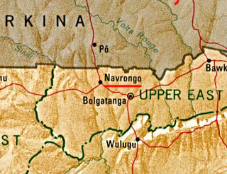
Navrongo is a town and the capital of Kassena-Nankana District in the Upper East Region of northern Ghana, adjacent to the border with Burkina Faso. Navrongo is the capital of Kassena-Nankana District – which is within the Upper East Region of northern Ghana. Navrongo has a 2012 settlement population of 27,306 people.

Nadowli District is a former district that was located in Upper West Region, Ghana. Originally created as an ordinary district assembly in 1988. However, on 28 June 2012, it was split off into two new districts: Nadowli-Kaleo District and Daffiama-Bussie-Issa District. The district assembly was located in the western part of Upper West Region and had Nadowli as its capital town.

The railway stations in Ghana serve a rail network concentrated in the south of the country.
Nandom is the capital town of the Nandom Municipal of the Upper West Region of Ghana.
Navrongo Solar Power Station is a 2.5 MW (3,400 hp) solar power plant in Ghana.
Pwalugu Hydroelectric Power Station is a 60 megawatts (80,000 hp) hydroelectric power station, under construction in Ghana. When completed, it is expected to connect to the planned 50 megawatts (67,000 hp) Kurugu Solar Power Station to form the 110 megawatts (150,000 hp) Pwalugu-Kurugu Hydro-Solar Hybrid Power Plant, the first of its type in the country.
The N12 or National Highway 12 is a national highway in Ghana that begins at the Ghana - Côte d'Ivoire border in the Western Region of Ghana and travels generally north to Hamile on the Ghana - Burkina Faso border. Its total length is 670 kilometres.
Pâ Solar Power Station, is a 30 megawatts (40,000 hp) solar power plant in Burkina Faso. The power station was commercially commissioned in December 2023.
The Gomoa Onyaadze Solar Power Station is an operational grid-connected 20 megawatts (27,000 hp) solar power plant, in Ghana. The privately owned power station sells its power to the Power Distribution Services Ghana (PDSG), formerly Electricity Company of Ghana (ECG), under a long-term power purchase agreement.
BXC Solar Power Station, also Onyandze Solar Power Station, is an operational 20 megawatt solar power plant in Ghana. The solar farm was developed, financed and is owned and operated by Beijing Xiaocheng Company, a Chinese independent power producer (IPP). The power station, commercially commissioned in April 2016, was the largest grid-ready IPP solar farm in Ghana, at that time. The energy generated at this power station is evacuated via a high voltage transmission line to a substation at Winneba Roundabout, where it enters the national grid.
The Pwalugu Multipurpose Dam is a planned dam across the White Volta River, in Ghana. The dam will create a reservoir with surface area measuring 350 square kilometres (135 sq mi). The reservoir is expected to provide irrigation water to an estimated 25,000 hectares of agricultural land. It will also supply drinking water to populations living downstream of the infrastructure. In addition, the dam will host the Pwalugu Hydroelectric Power Station, with generating capacity of 60 MW (80,000 hp).
The Nagreongo Solar Power Station, also Nagréongo Solar Power Station, is a 30 MW (40,000 hp) solar power in Burkina Faso. The solar farm, which was commissioned in July 2022, was developed by the French IPP, GreenYellow, a subsidiary of the Casino Group. The energy generated here is sold to the Burkinabe electricity utility company SONABEL,, under a 25-year power purchase agreement (PPA).
Kodeni Solar Power Station, is a 38 MW (51,000 hp) solar power plant in Burkina Faso. The solar farm was development by the French IPP, Africa Ren, with funding from European financial institutions, led by FMO Entrepreneurial Development Bank of the Netherlands. Société Nationale d'électricité du Burkina Faso (SONABEL), the state-owned electricity utility company signed a 25-year power purchase agreement (PPA), with Koden Solar SASU, the special purpose vehicle company established by the owners to own, develop, operate and maintain the solar farm. The power station reached commercial commissioning in December 2023.

The Ambatolampy Solar Power Station is a 40 MW solar power plant in Madagascar. As of April 2022, it was the first grid-connected, privately-funded solar power plant in the country. The power plant, which was first commissioned in 2018, underwent expansion from 20 MW to 40 MW, between 2021 and 2022. The off-taker of the power generated at this renewable energy power plant is Jirama, the national electricity utility company.
The Tenkodogo Power Station, also Zano Solar Power Station, is a 28 MW (38,000 hp) solar power plant in Burkina Faso. The solar farm is under development by a special purpose vehicle (SPV) company called Quadran Burkina Faso S.A. (Zano), created by the owners, to design, finance, build, own, operate and maintain the power station. The energy off-taker is Société Nationale d'électricité du Burkina Faso (SONABEL), the national electricity utility parastatal company, under a long-term power purchase agreement.
The Kaleo Power Station is a 13 MW (17,000 hp) solar power plant in Ghana. The solar farm is owned and was developed by the Volta River Authority, between February 2020 and August 2022. The power off-taker is GRIDCo, which integrates the electricity into the national grid.
The De Aar 1 Solar Power Station is an 85.26 MW solar power plant in South Africa. The solar farm is owned by South African independent power producer (IPP), Solar Capital (Pty) Limited, a subsidiary of the Phelan Energy Group, which is headquartered in Dubai, United Arab Emirates. The off-taker of the power generated here is Eskom Holdings, the national electricity parastatal company, under a 20-year power purchase agreement (PPA).
The Donsin Solar Power Station is a 25 megawatts solar power plant under development in Burkina Faso. The power station is owned and is being developed by the Government of Burkina Faso, through the Ministry of Energy, Mines and Quarries. The off-taker of the power generated here is Société Nationale d'électricité du Burkina Faso (SONABEL), the Burkinabe national electricity utility company. The project received funding support, in the form of a €45.7 million concessional loan from the Export-Import Bank of China.