Related Research Articles
Dadeldhura, a part of Sudurpashchim Province, is one of the seventy-seven districts of Nepal. The district, with Dadeldhura as its district headquarters, covers an area of 1,538 km2 (594 sq mi) and had a population of 126,162 in 2001 and 142,094 in 2011.

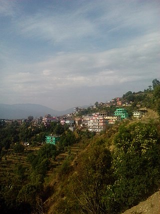
Salyan District, a part of Karnali Province, is one of the seventy-seven districts of Nepal. Salyan covers an area of 1,462 km2 (564 sq mi) with a population of 213,500 in 2001 and 241,716 in 2011. The district's administrative center is named Salyan or Salyan Khalanga, today it is part of Shaarada Municipality.
Triveni is a rural municipality in Salyan District in the Karnali Province of western-central Nepal. At the time of the 1991 Nepal census it had a population of 3789 people living in 710 individual households.
Sharada Municipality is a municipality located in Salyan District of Karnali Province in western Nepal. This municipality was formed on May 18, 2014. It was formed by merging seven Village Development Committees: Dandagaun, Hiwalcha, Kajeri, Khalanga, Marke, Saijuwal Takura and Syanikhal.
Gurbhakot is an urban municipality located in Surkhet District of Karnali province of Nepal.
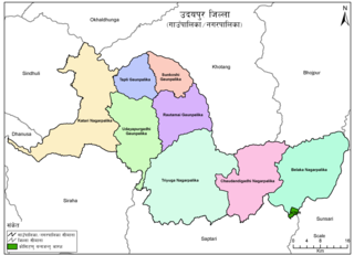
Udayapurgadhi Rural Municipality is a rural municipality in Udayapur District of Koshi Province in Nepal. There are 4 rural municipalities in Udayapur District. There are 8 wards in this municipality. According to 2011 census of Nepal, the total population of the municipality is 30,731 and total area is 269.51 km². The headquarter of the municipality is in Panchawati
Bangad Kupinde is an urban municipality located in Salyan District of Karnali Province of Nepal.
Thantikandh is a rural municipality located in Dailekh District of Karnali Province of Nepal.
Kapurkot is a rural municipality located in Salyan District of Karnali Province of Nepal.
Chhatreshwori is a rural municipality located in Salyan District of Karnali Province of Nepal.
Darma is a rural municipality located in Salyan District of Karnali Province of Nepal.
Siddha Kumakh is a rural municipality located in Salyan District of Karnali Province of Nepal.
Kumakh is a rural municipality located in Salyan District of Karnali Province of Nepal.
Barahatal is a rural municipality located in Surkhet District of Karnali Province of Nepal.
Simta is a rural municipality located in Surkhet District of Karnali Province of Nepal.
Chingad is a rural municipality located in Surkhet District of Karnali Province of Nepal.
Bhume is a rural municipality located in Eastern Rukum District of Lumbini Province Province of Nepal.
Annapurna Rural Municipality, Kaski is a Gaunpalika in Kaski District in Gandaki Province of Nepal named after the Annapurna Mountain. On 12 March 2017, the Government of Nepal implemented a new local administrative structure. With the implementation of the new local administrative structure, VDSs have been replaced with Municipal and Village Councils. Annapurna Gaupalika is one of these 753 local units.
Myagde Rural Municipality (Myagde Gaupalika) (Nepali: म्याग्दे गाउँपालिका) is a Gaunpalika in Tanahaun District in Gandaki Province of Nepal. On 12 March 2017, the government of Nepal implemented a new local administrative structure, in which VDCs have been replaced with municipal and Village Councils. Myagde is one of these 753 local units.
Babai Rural Municipality is a Gaunpalika in Dang District in Lumbini Province of Nepal. On 12 March 2017, the government of Nepal implemented a new local administrative structure, with the implementation of the new local administrative structure, VDCs have been replaced with municipal and Village Councils. Babai is one of these 753 local units. Babai Rural Municipality has area of 257.48 km2. Babai RM is surrounded by Shantinagar Rural Municipality and Dangisharan Rural Municipality in the east, Banke district in the west, Salyan district in the north and in south there is Dangisharan Rural Municipality and Banke district.
References
- ↑ "Kalimati (Rural Municipality, Nepal) - Population Statistics, Charts, Map and Location". www.citypopulation.de. Retrieved 1 January 2019.
- ↑ "The Rising Nepal: Salyan's Kalimati without telephone service for two months". therisingnepal.org.np. Retrieved 1 January 2019.
- ↑ NepalMap Language
- ↑ NepalMap Caste
- ↑ NepalMap Religion
- ↑ NepalMap Literacy
