
The Krishna River in the Deccan plateau is the third-longest river in India, after the Ganga and Godavari. It is also the fourth-largest in terms of water inflows and river basin area in India, after the Ganges, Indus and Godavari. The river, also called Krishnaveni, is 1,400 kilometres (870 mi) long and its length in Maharashtra is 282 kilometres. It is a major source of irrigation in the Indian states of Maharashtra, Karnataka, Telangana and Andhra Pradesh.

The Godavari is India's second longest river after the Ganga River and drains the third largest basin in India, covering about 10% of India's total geographical area. Its source is in Trimbakeshwar, Nashik, Maharashtra. It flows east for 1,465 kilometres (910 mi), draining the states of Maharashtra (48.6%), Telangana (18.8%), Andhra Pradesh (4.5%), Chhattisgarh (10.9%) and Odisha (5.7%). The river ultimately empties into the Bay of Bengal through an extensive network of distributaries. Its 312,812 km2 (120,777 sq mi) drainage basin is one of the largest in the Indian subcontinent, with only the Ganga and Indus rivers having a larger drainage basin. In terms of length, catchment area and discharge, the Godavari is the largest in peninsular India, and had been dubbed as the Dakshina Ganga.
Vijayawada, also known by its colonial name Bezawada, is the second largest city and commercial hub in the Indian state of Andhra Pradesh. The city is part of the Andhra Pradesh Capital Region and is located on the banks of the Krishna River surrounded by the hills of the Eastern Ghats, known as the Indrakeeladri Hills. The city is home to the important Hindu shrine of Kanaka Durga Temple. It geographically lies on the center spot of Andhra Pradesh. The city has been described as the commercial, political, cultural and educational capital of Andhra Pradesh. It is the administrative headquarters of NTR district. The Prakasam Barrage across the Krishna River connects the NTR and Guntur districts.

Coastal Andhra, also known as Kosta Andhra, is a geographic region in the Indian state of Andhra Pradesh, comprising the coastal districts of the state between the Eastern Ghats and the Bay of Bengal, from the northern border with Orissa to Rayalaseema in the south. It includes major cities such as Visakhapatnam and Vijayawada as well as the state capital Amaravati and is recognized for its fertile lands, rich cultural heritage, and economic importance. Coastal Andhra plays a significant role in the state's agricultural output, particularly in rice and tobacco production, supported by abundant water resources from the Godavari, Krishna, and Penna rivers.

Rajahmundry, officially Rajamahendravaram, is a city in the Indian state of Andhra Pradesh and district headquarters of East Godavari district. It is the seventh most populated city in the state. During British rule, the district of Rajahmundry was created in the Madras Presidency in 1823. It was reorganised in 1859 and bifurcated into the Godavari and Krishna districts. Kakinada was the headquarters of Godavari district, which was further bifurcated into East Godavari and West Godavari districts in 1925. It is administered under Rajahmundry revenue division of the East Godavari district. The city is known for its floriculture, history, culture, agriculture, economy, tourism, and its heritage. It is known as the "Cultural Capital of Andhra Pradesh".

The West Godavari district is a coastal district in the Indian state of Andhra Pradesh with an administrative headquarters in Bhimavaram. As of the 2011 Census of India, the district has an area of 2,178 km2 (841 sq mi) and a population of 1,779,935. It is bounded by the Krishna district and Bay of Bengal to the south, East Godavari district to the east, and Eluru district, Kolleru Lake and Upputeru Drain to the northwest.

Kovvur is a town in the East Godavari district of the Indian state of Andhra Pradesh. It is a municipality and the mandal headquarters of Kovvur mandal in Kovvur revenue division.

Nagarjuna Sagar Dam is a masonry dam across the Krishna River at Nagarjuna Sagar which straddles the border between Palnadu district in Andhra Pradesh and Nalgonda district in Telangana. The dam provides irrigation water to the districts of Krishna, Guntur, Palnadu, Prakasam and parts of West Godavari districts of Andhra Pradesh and also Nalgonda, Suryapet, Khammam, Bhadradri Kothagudem districts of Telangana. It is also a source of electricity generation for the national grid.

Nidadavolu is a town in East Godavari district of the Indian state of Andhra Pradesh. It is a municipality and the mandal headquarters of Nidadavole mandal in Kovvur revenue division.

Kanaka Durga Temple, officially known as Sri Durga Malleswara Swamyvarla Devasthanam, is a Hindu temple dedicated to Kanaka Durga. The deity in this temple is also popularly referred as Kanaka Durga. The temple is located in Vijayawada, Andhra Pradesh, India on the Indrakeeladri hill on the banks of Krishna River. Kaalika Purana, Durgaa Sapthashati and other Vedic literature have mentioned about Kanaka Durga on the Indrakeelaadri and have described the deity as Swayambhu, (self-manifested) in Triteeya Kalpa.
The Godavari Bridge or Kovvur–Rajahmundry Bridge is a truss bridge spanning the Godavari River in Rajahmundry, India. It is India's fourth longest road-cum-rail bridge crossing a water body, the first one being the Bogibeel Bridge over the Brahmaputra in Assam, and second is Digha–Sonpur Bridge over the Ganga in Bihar.

Budameru is a rivulet in NTR district which originates in the hills surrounding Mylavaram and empties itself into Kolleru Lake. Budameru is also known as The Sorrow of Vijayawada. In order to control the floods, the rivulet was controlled with the Velagaleru Regulator at Velagaleru village and a diversion channel named, Budameru Diversion Channel (BDC) was constructed from Velagaleru to join Krishna River upstream of Prakasam Barrage.

Andhra Pradesh is a state in India. Andhra Pradesh Tourism Development Corporation (APTDC) is a state government agency which promotes tourism in Andhra Pradesh, describing the state as the Koh-i-Noor of India. Andhra Pradesh has a variety of tourist attractions including beaches, hills, caves, wildlife, forests and temples.
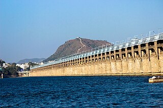
The Prakasam Barrage stretches 1223.5 m across the Krishna River connecting Vijayawada and Guntur districts in Andhra Pradesh, India. The barrage serves also as a road bridge and spans over a lake. The three canals associated with the barrage run through the city of Vijayawada, crossing it and giving it a Venetian appearance.
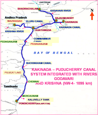
National Waterway 4 (NW-4) is a 1,095 kilometres (680 mi) long waterway in India. It has been declared as an Indian National Waterway and is currently under development. It connects the Indian states of Telangana, Andhra Pradesh, Tamil Nadu, and the union territory of Puducherry. The NW-4 runs along the Coromandal Coast through Kakinada, Eluru, Commanur, Buckingham Canals and also through part of Krishna and Godavari rivers in South India. It was declared a National Waterway on 24 November 2008 under the Provisions of National Waterways Bill, 2006. It is being developed by the Inland Waterways Authority of India (IWAI), and was scheduled for completion by 2013. The National Waterways Act, 2016 has extended the length of NW-4 from 1,095 km (680 mi) to 2,890 km (1,800 mi) by connecting the Krishna and Godavari Rivers. The Project would be undertaken in 3 phases with first phase beginning in October, 2017 and to be completed by June, 2019

The Polavaram Project is an under construction multi-purpose irrigation project on the Godavari River in the Eluru District and East Godavari District in Andhra Pradesh. The project has been accorded National project status by the Central Government of India. Its reservoir back water spreads up to the Dummugudem Anicut and approx 115 km on Sabari River side. Thus back water spreads into parts of Chhattisgarh and Odisha States. It gives major boost to tourism sector in Godavari Districts as the reservoir covers the famous Papikonda National Park, Polavaram hydro electric project (HEP) and National Waterway 4 are under construction on left side of the river. It is located 40 km to the upstream of Sir Arthur Cotton Barrage in Rajamahendravaram City and 25 km from Rajahmundry Airport.

Vykuntapuram, also spelled as Vaikuntapuram, is a village in Guntur district of the Indian state of Andhra Pradesh. It is located in Amaravathi mandal of Guntur revenue division. The village forms a part of Andhra Pradesh Capital Region, under the jurisdiction of APCRDA.
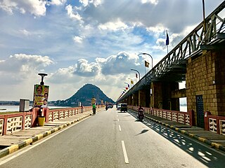
The Kanakadurga Flyover is a flyover spanning the Krishna River and Prakasam Barrage in Vijayawada, India. As of 2022, it is the longest flyover in Andhra Pradesh with a length of 2.6 kilometres (1.6 mi). It was opened on 16 October 2020 by Nitin Gadkari.

There are various modes of transportation available in Rajahmundry and its region in India. Although Auto rickshaws, bicycles are mostly used, mass transit systems – such as buses and trains. It is home for a domestic airport located near Madhurapudi and is named as Rajahmundry Airport.
