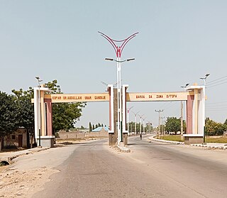
Bauchi State is a state in the North-East geopolitical zone of Nigeria. It is bordered by Jigawa to the north, Yobe to the northeast, Gombe to the east, Taraba and Plateau to the south, Kaduna to the west and Kano to the northwest. It takes its name from the historic city of Bauchi, which also serves as its capital. The state was formed in 1976 when the former North-Eastern State was broken up. It originally included the area that is now Gombe State, which became a distinct state in 1996.
Boghom is an Afro-Asiatic language spoken by the majority of people in Kanam & Wase local government of Plateau State, Nigeria.
Kirfi is a Local Government Area of Bauchi State, Nigeria, bordering Gombe State in the east. Its headquarters are in the town of Cheledi. The northeasterly line of equal latitude and longitude passes through the Local Government Area.
Zaki is a Local Government Area of Bauchi State, Nigeria. Its headquarters are in the town of Katagum.
Balanga is one of the eleven local government areas in Gombe State, Nigeria. It falls under the southern senatorial district of the state. Its administrative headquarters is located at Talasse town. The LGA is bordered by Yemaltu-Deba LGA to the north while to the south and east by Adamawa state and to the west by Shongom, Kaltungo and Akko LGA.

Kafin Hausa is a Local Government Area of Jigawa State, Nigeria. Its headquarters are in the town of Kafin Hausa.
Dutsi is a Local Government Area in Katsina State, Nigeria. Its headquarters is in the town of Dutsi in north Nigeria.

Gezawa is a Local Government Area in Kano State, Nigeria. Gezawa Local Government Area administrative headquarters is in the town of Gezawa with its area council made up of Jogana, Gawo, Zango, Tumbau, Wangara, Sarain-Gezawa, Babawa, Ketatwa and Tsamiya-Dabba. It has an area of 340 km2 and a population of 282,069 at the 2006 census. Hausa and Fulani ethnic groups make up the majority of the local population. The majority religion practiced in the region is Islam, and the languages spoken there are Fufulde and Hausa.

Dawakin Tofa is a Local Government Area in Kano State, Nigeria. Its headquarters are in the town of Dawakin Tofa and It includes a number of cities and villages, such as Alajawa, Bagari, Bankaura, Dandalama, Jobenkun, Kaleku, Rumi and Yelwa. Hausa and Fulani ethnic divides being the two most notable tribes. The Hausa and Fufulde languages are widely spoken in the region, and Islam is the most commonly practiced religion there. The Dawakin Tofa General Hospital and the Dawakin Tofa Science College are well-known structures in Dawakin Tofa.
Fagge is a Local Government Area in Kano State, Nigeria, within the state metropolitan. Its headquarters are in the suburb of Waje.
Doguwa is a Local Government Area in the extreme south of Kano State, Nigeria. Its headquarters are in the town of Riruwai.
Garko is a Local Government Area in Kano State, Nigeria. Its headquarters are in the town of Garko on the A237 highway.
Sanga is a Local Government Area in southern Kaduna State, Nigeria. Its headquarters is in the town of Gbantu. The Local Government Council is chaired by Bisallah Malam. It has an area of 1,821 km2 and had a population of 151,485 as at the 2006 census. The postal code of the area is 801.
Kaura is a town and a Local Government Area in southern Kaduna State, Nigeria. Its headquarters are in the town of Kaura in Asholyio (Moroa) Chiefdom. The Local Government Council is chaired by Matthias Siman. Other towns include: Manchok and Kagoro. It has an area of 461 km2 and a population of 174,626 at the 2006 census. The postal code of the area is 801.
Bassa is a Local Government Area in the north of Plateau State, Nigeria, bordering Kaduna and Bauchi States. Its headquarters are in the town of Bassa at9°56′00″N8°44′00″E.

Mangu is a Local Government Area in Plateau State, Nigeria. Governor Caleb Mutfwang appointed Markus Artu as the Transition Committee Chairman of the LGA. Its headquarters are in the town of Mangu at 9°31′00″N9°06′00″E.
Shendam is a Local Government Area in Plateau State, Nigeria. Its headquarters are in the town of Shendam. It is bordered by Ibi Taraba State to the south, Qua'an Pan to the east, Pankshin to the north, and Mikang to the west. Shendam town is the second most populous town in Plateau State, after Jos town at 8°53′00″N9°32′00″E.
Pyem is a Plateau language of Nigeria. It is spoken by the people of Pyem Chiefdom with headquarters in Gindiri. Pyem is one of the indigenous languages spoken in Mangu LGA, Plateau State, Nigeria.
Atsam, is a Kainji language of Nigeria. It is spoken by the Atsam people, mainly found in Kauru LGA of Kaduna State and Bassa LGA of Plateau State, Middle Belt, Nigeria.
Bashar is a town and district in Wase Local Government Area, Plateau State.


