This Kandramanickam is often confused to be the original settlement of Brahacharanam Brahmins, who share a close affinity to the Sama Veda, Bharadwaja Gothra Iyengars. This often results as a result of two villages with similar names. A very strong reason to dispute the Kandramanickam of Sivaganga District for its links to Brahacharanam Brahmins is the fact of its geographic distance to the Nachiar Koil area, near which lies a very small, sleepy village called Kandramanicakm. It is more on the Kudavasal vicinity, as the Tamil Nadu Pincode listing for the village Kudavasal is under the Kudavasal Taluk of Thiruvaiyaru District. Thiruvaiyaru district lies closer to Kumbakonam and Thanjavur. See Also: Brahacharanam Going through the Brahacharanam link, it can be readily noted that the subgroups listed there mostly belong to villages and towns in and around Kudavasal Taluk, Thiruvaiyaru District.
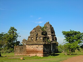
The village Kandiramanickam [10°54'33.48"N 79°30'56.97"E] lies 6 km east of Nachiyar Koil and is midway between Nachiyar koil and Marudancheri. The village has a Perumal temple, which is visited by a Bhattar only in the mornings. He travels from another town 10 km from Kandramanickam. Once a very densely populated village of Brahacharana Brahmins and Bharadwaja Gothra Iyengars, this town today is devoid of any Brahmins. Brahacharanam Brahmin settlements were all established during the Cola period in the heart of the Chola territory. The Kandiramanickam Brahacharanam was one of them probably in memory of Kandarathitha Chola.
Transports
Kandaramanickam is well connected by public transport from both Karaikudi and Thirupatthur. Both these places are well connected by road transport and Karaikudi is connected by rail as well.
Temple
There is a temple located in the centre of the village, Kandaramanickam, dedicated to Manickka Naachi Amman. An annual festival (Thiruvizha) takes place in April, which includes Chariot procession, Palkudam & Manjuvirattu. According to legend, Sri Manickanachi amman was a very powerful Goddess and only truth won in her vision and the Goddess punished liars severely.
Thiruvaiyaru is a panchayat town in Thanjavur District in the Indian state of Tamil Nadu. Thiruvaiyaru is situated on the banks of the river Kaveri, 11 km (6.8 mi) from North of Thanjavur. National Highway No.136 from Thanjavur connect Thiruvaiyaru, Ariyalur, Perambalur byepass and Aththur bypass. State roads to Kumbakonam at 37 km (23 mi) in the East and Kallanai 33 km in the West connect Thiruvaiyaru.
Ramanathapuram, also known as Ramnad, is a town and a municipality in Ramanathapuram district in the Indian state of Tamil Nadu. It is the administrative headquarters of Ramanathapuram district and the second largest town in Ramanathapuram district. As of 2011 census, the town had a population of 61,440.Density of population: 320 people per square kilometer; Literacy Rate: 81.48% - Male: 87.89%, Female: 74.93%; Male Female Ratio: 1000:977.Ramanathapuram is the top producer of chilli pepper in Tamil Nadu. It is connected to other cities by NH-49.
Sivaganga is a town and headquarters of the Sivaganga district in the Indian state of Tamil Nadu. The town is located at a distance of 48 km (30 mi) from Madurai and 449 km (279 mi) from the state capital Chennai. It is an important town in this district for official and commercial purposes.
Thirumayam is a place of historical importance located about 20 km south of the town of Pudukkottai, Tamil Nadu, India. The noted Indian independence activist Sathyamurthy was born in Thirumayam in 1887.
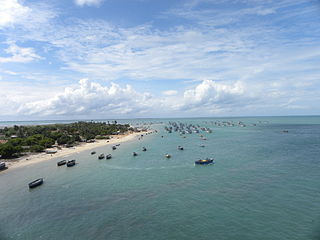
Ramanathapuram District, also known as Ramnad District, is one of the 38 districts an administrative districts of Tamil Nadu state in southern India. The town of Ramanathapuram is the district headquarters. Ramanthapuram District has an area of 4123 km2. It is bounded on the north by Sivaganga District, on the northeast by Pudukkottai District, on the east by the Palk Strait, on the south by the Gulf of Mannar, on the west by Thoothukudi District, and on the northwest by Virudhunagar District. The district contains the Pamban Bridge, an east-west chain of low islands and shallow reefs that extend between India and the island nation of Sri Lanka, and separate the Palk Strait from the Gulf of Mannar. The Palk Strait is navigable only by shallow-draft vessels. As of 2011, Ramanathapuram district had a population of 1,353,445 with a sex-ratio of 983 females for every 1,000 males.
Sivaganga District is one of the 38 districts in Tamil Nadu state, India. Sivaganga is the district headquarters. It is bounded by Pudukkottai district on the Northeast, Tiruchirapalli district on the North, Ramanathapuram district on South East, Virudhunagar district on South West and Madurai District on the West. Karaikudi is the most populous centre in the district. The area's other larger towns include Sivagangai, Kalayar Kovil, Devakottai, Manamadurai, and Tiruppattur. As of 2011, the district had a population of 1,339,101 with a sex ratio of 1,003 females for every 1,000 males.
Singampunari is a town in Sivagangai district, in Tamil Nadu, India. The town comes under Singampunari taluk. Singampunari is about 47 km from Madurai, 58 km from Dindigul, 216 km from Coimbatore, 65 km from Tiruchi, 50 km from Karaikudi, 8 km from Nellukundupatti;being 7 km from Kottampatti which lies along the Madurai-Chennai highways. It also lies on the Coimbatore-Palani - Karaikudi-Devakottai route. So all the buses from Coimbatore to Chettinad region via Palani stops in Singampunari. It was made up military cantonments. Since it is in the northern belt of Pandya country, it had a network of forts. &
Kudavasal or Kodavasal is a panchayat in Thiruvarur district in the Indian state of Tamil Nadu. The town is the headquarters of Kudavasal taluk.
Manamadurai is a Town in Manamadurai Division of Sivaganga district in the Indian state of Tamil Nadu. Manamadurai is the headquarter of Manamadurai taluk. Manamadurai falls under Manamadurai Legislative assembly. Manamadurai name transferred/Comes from Vanavan Maruthadurai. This Town is famous for ancient Sri Veera Azhagar temple or Sri Sundararaja Perumal Koil. The legends around this temple and the place trace back to the era of Ramayana, and the place has been referred to as Vanara Veera Madura Puri in ancient times. It has a population density of more than 6000 Persons/km2 which is Top in Sivagangai District.
Nattarasankottai is a village in Sivaganga district in the Indian state of Tamil Nadu.
Arani taluk is a taluk of Tiruvannamalai district of the Indian state of Tamil Nadu. The headquarters is the town of Arani.
Keelrajakularaman is a village in Rajapalayam Taluk, Virudhunagar District Tamil Nadu, India. This village is situated about 12 km from Rajalapalayam on the way to Alangulam Cement Factory.
Tiruppathur, also spelt Thiruppathur / Thirupputhur, is a Taluk, Town Panchayat in Sivaganga district in the India state of Tamil Nadu. Tiruppathur is situated at Sivaganga district, 27 km from Sivaganga 22 km away from Karaikudi. The place is famous for Thiruthalinathar Temple, a Padal petra sthaalam, which is the sixth of the fourteen such in the Pandyan region.
Rajendrapuram is a village in the Aranthangi revenue block of Pudukkottai district, Tamil Nadu, India.
Vedal, pronounced as Vaedaal is a village in the Cheyyur taluk, Sathurvedi means - A Land where all 4 VEDAS are keenly practiced Kanchipuram district of Tamil Nadu, India. It is located 105 kilometres (65 mi) away from Chennai and 45 kilometres (28 mi) away from Pondicherry on the Tamil Nadu East Coast Road ECR. Vedal is situated about 10 kilometres (6.2 mi) far from the Bay of Bengal coast and is well known for the temple of Shiva VADAVAYIL ANDAVAR(means - Chola's Northern gateway GOD) located here, once upon a time it was the northern entrance for The great Chola Dynasty. It was the last among the temples built by the king Raja Raja Chola I.
Alampattu is a village in the state of Tamil Nadu, Sivaganga District, India. It is 20 km from the town Karaikudi.
Sethanipuram is a village situated in Thiruvarur District in Tamil Nadu, India. It was part of Tanjore District during British rule.
S.V Mangalam (Sadurvadamangalam) is a village in Singampunari Taluk, Sivaganga district, Tamil Nadu, India, 500 kilometers from the state capital of Chennai.
Kulipirai is a village in Thirumayam Taluk in Pudukkottai District of Tamil Nadu, India. It is located 25 km towards west from district headquarters Pudukkottai. 14 km from Thirumayam. 60 km from Tiruchirapalli. 415 km from State capital Chennai. The nearest airport is Tiruchirapalli International Airport 52 km away.
This page is based on this Wikipedia article Text is available under the CC BY-SA 4.0 license; additional terms may apply. Images, videos and audio are available under their respective licenses.