Kandreho is a municipality in western Madagascar in Betsiboka Region approximately 200 kilometres (120 mi) north-west of the capital Antananarivo. It is situated at 144 km from Maevatanana.

Maevatanana is an urban municipality in Madagascar. The city is in the central-north part of the island, at the Ikopa River, and is connected by the national road RN 4 to Antananarivo and Mahajanga. The altitude is low and as it is located far from the coast, temperatures tend to be high. The city belongs to the district of Maevatanana, which is a part of Betsiboka Region. Maevatanana is the capital of the Betsiboka region, and the population of the commune was estimated to be approximately 24,000 in 2001 commune census.
Ambodimanga is a municipality in Madagascar. It belongs to the district of Ambanja, which is a part of Diana Region. According to 2001 census the population of Ambodimanga was 5,729.
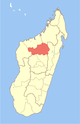
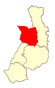
Betsiboka is a region of Madagascar. It borders Boeny Region in north, Sofia in northeast, Alaotra-Mangoro in east, Analamanga and Bongolava in south and Melaky in west. The capital of the region is Maevatanana. Until 2009 Betsiboka belonged to Mahajanga Province. The population was 394,561 in 2018 within the area of 30,025 km2 (11,593 sq mi). Betsiboka is one of the least densely populated regions in Madagascar.
Besalampy is a district in western Madagascar. It is a part of Melaky Region and borders the districts of Soalala in northeast, Kandreho in east, Ambatomainty in southeast, Morafenobe in south and Maintirano in southwest. The area is 11,753 km2 (4,538 sq mi) and the population was estimated to be 37,782 in 2001.
Maevatanana II is a rural municipality in Madagascar. It covers the villages around the town of Maevatanana and belongs to the district of Maevatanana, which is a part of Betsiboka Region. The population of the commune was estimated to be approximately 16,000 in 2001 commune census.
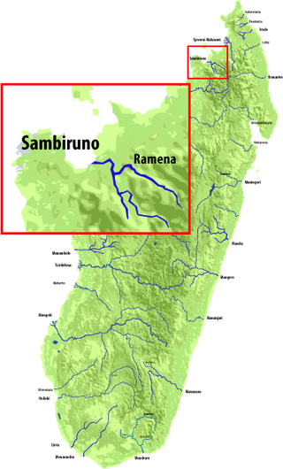
The Sambirano is a river of northwestern Madagascar in the region of Diana. It has its sources at the Maromokotra peak and flows through the Tsaratanana Reserve to the Indian Ocean. Its delta occupies 250 km2.
The Betsiboka Bridge is a truss bridge over the Betsiboka River, in the district of Maevatanana, which is a part of Betsiboka Region, Madagascar. It is one of the longest bridge on the island, appr. 350 meters long.
Belon'i Tsiribihina is a district of the Menabe region of Madagascar and borders the Miandrivazo region to the east, the Mahabo to the southeast, and the Morondava to the southwest. The district has an area of 8,038 km2 (3,103 sq mi), and the estimated population in 2020 was 138,775.
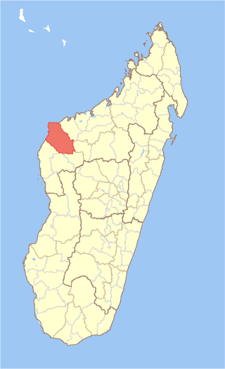
Maevatanana is a district of Betsiboka in Madagascar.
Mahanoro is a district of Atsinanana in Madagascar. The district has an area of 3,763 km2 (1,453 sq mi), and the estimated population in 2020 was 299,459.
Manakara-Atsimo is a district of Fitovinany in Madagascar. The main city is Manakara.

Maroantsetra is a district of Analanjirofo in Madagascar. It hosts part of Masoala National Park and part of Makira Natural Park. The district has an area of 6,965 km2 (2,689 sq mi), and the estimated population in 2020 was 264,234.
Miandrivazo is a district of Menabe in Madagascar. It is crossed by the Manambolo River. The district has an area of 12,330 km2 (4,760 sq mi), and the estimated population in 2020 was 162,462.
Bemaneviky Ouest is a municipality in Madagascar. It belongs to the district of Ambanja, which is a part of Diana Region. According to 2018 census the population was 5,841.
Andasibe is a rural municipality in Madagascar. It belongs to the district of Kandreho, which is a part of Betsiboka. The population of the commune was estimated to be approximately 487 in 2018. It's hell: 393 men for 94 woman only.
Berivotra is a rural municipality in Madagascar. It belongs to the district of Maevatanana, which is a part of Betsiboka Region. The population of the municipality was 14,675 in 2018.
Benavony is a rural municipality in northern Madagascar. It belongs to the district of Ambanja, which is a part of Diana Region.
Maevatanana is a rural municipality in northern Madagascar, 24km from Ambanja. It lies in the valley of the Sambirano River that is the main cocoa producing area of Madagascar. 60% or 7500 to 10 000 ton yearly provide from this area. There is an unpaved piste from Ambanja to Marovato, via Benavony, Ambodimanga Ramena, Bemaneviky Ouest, Maevatanana that is hardly practicable. Most of the exported cocoa is therefore transported with boats on the Sambirano River.
Behazomaty is a rural commune in Madagascar. It belongs to the district of Kandreho, which is a part of Betsiboka. It is situated at 50km East from Kandreho, the capital of the district. It is situated at the Menavava river.