Kandreho Formation

Last updated
Kandreho Formation
Stratigraphic range: Toarcian
~180–176  Ma
O
S
D
C
P
T
J
K
Pg
N
Type Geological formation
Lithology
Primary Marly limestone
Location
Coordinates 17°30′S45°18′E / 17.5°S 45.3°E / -17.5; 45.3
Approximate paleocoordinates 22°18′S24°00′E / 22.3°S 24.0°E / -22.3; 24.0
Region Mahajanga Province
CountryFlag of Madagascar.svg  Madagascar
Extent Mahajanga Basin
Type section
Named for Kandreho
Named byGeiger
Year defined2004
Madagascar physical map.svg
Blue pog.svg
Outcrop of the formation in Madagascar

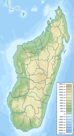
The Kandreho Formation is an Early Jurassic (middle or late Toarcian) geological formation of the Mahajanga Basin of Madagascar. The marly limestones of the formation were deposited in a subtidal lagoonal environment. The formation overlies the Bouleiceras and Spiriferina beds of the early Toarcian and has been correlated to the Marrat Formation of Saudi Arabia. Fossils of the marine crocodylian Andrianavoay (originally classed as a species of Steneosaurus ) as well as bivalves and the ammonite Nejdia have been found in the formation. [1] [2] The name Kandreho Formation was proposed by Geiger in 2004. [3]

Contents

See also

Related Research Articles

<span class="mw-page-title-main">Navajo Sandstone</span> Geologic formation in the southwestern United States

The Navajo Sandstone is a geological formation in the Glen Canyon Group that is spread across the U.S. states of southern Nevada, northern Arizona, northwest Colorado, and Utah as part of the Colorado Plateau province of the United States.

<span class="mw-page-title-main">Fernie Formation</span>

The Fernie Formation is a stratigraphic unit of Jurassic age. It is present in the western part of the Western Canada Sedimentary Basin in western Alberta and northeastern British Columbia. It takes its name from the town of Fernie, British Columbia, and was first defined by W.W. Leach in 1914.

<span class="mw-page-title-main">Posidonia Shale</span> Early Jurassic geological formation of south-western Germany

The Posidonia Shale geologically known as the Sachrang Formation, is an Early Jurassic (Toarcian) geological formation of southwestern and northeast Germany, northern Switzerland, northwestern Austria, southern Luxembourg and the Netherlands, including exceptionally well-preserved complete skeletons of fossil marine fish and reptiles. The Posidonienschiefer, as German paleontologists call it, takes its name from the ubiquitous fossils of the oyster-related bivalve Posidonia bronni that characterize the mollusk faunal component of the formation.

<span class="mw-page-title-main">Whitby Mudstone</span> Geological formation in Yorkshire, UK

The Whitby Mudstone is a Toarcian geological formation in Yorkshire and Worcestershire, England. The formation, part of the Lias Group, is present in the Cleveland and Worcester Basins and the East Midlands Shelf.

The Los Molles Formation is a geologic formation of Early to Middle Jurassic age, located at northern and central part of Neuquén Basin at Mendoza Shelf in Argentina. It is overlain by the Niyeu–Lajas Formation.

The Whiteaves Formation is a geologic formation in British Columbia. It preserves fossils dating back to the Jurassic period.

The Marne de Flize is a geologic formation in France. It preserves fossils dating back to the Toarcian stage of the Jurassic period.

The Cattamarra Coal Measures is an Early Jurassic geological unit in Western Australia.

The Bemaraha Formation is a Middle Jurassic geological formation of the Morondava Basin of Madagascar. The lime mudstones, grainstones and limestones of the formation were deposited in lagoonal and reefal environments. Fossils of groups of invertebrates and theropod and sauropod tracks have been found in the formation. The Sahalaly River tracksite yielded a single trackway belonging to a quadrupedal dinosaur, possibly a sauropod. Sauropod tracks are rare, making up as little as 1 percent of the present sample. The best-preserved tracks are assigned to the ichnogenus Kayentapus.

The Toyora Group is one of the Mesozoic strata in Japan, and was originally named Toyoura Series by Hisakatsu Yabe in 1920. The present name was defined by Tatsuro Matsumoto in 1949.

The Calcare di Sogno is a geological formation in Italy, dated to roughly between 182-169 million years ago and covering the Lower Toarcian-Late Bajocian stagess of the Jurassic Period in the Mesozoic Era. Thallatosuchian remains are known from the formation, as well fishes and other taxa.

<span class="mw-page-title-main">Ciechocinek Formation</span> Jurassic geologic formation in Europe

The Ciechocinek Formation, known in Germany as the Green Series is a Jurassic geologic formation that extends across the Baltic coast, from Grimmen, Germany, to Lithuania, with its major sequence in Poland and a few boreholes in Kaliningrad. It represents the largest largest continental area defined as deltaic in the fossil record, estimated to cover ∼7.1 × 100,000 km2 (39,000 sq mi) only in the Polish realm. It is mostly known by its diverse entomofauna, composed of more than 150 species of different groups of insects, as well its marine vertebrate fossils, including remains of sharks, actinopterygians and marine reptiles, along terrestrial remains of dinosaurs, including the early thyreophoran Emausaurus and others not yet assigned to a definite genus. Its exposures are mostly derived from active clay mining of a dislocated glacial raft with exposed Upper Pliensbachian to late Toarcian shallow-marine sediments. Starting with coarse and fine sand deposits with concretions, the pure clay of the Ciechocinek Formation, after the falciferum zone, was deposited in a restricted basin south of the Fennoscandian mainland. It hosts a layer full of carbonate concretions, where a great entomofauna is recovered.

The Lava Formation is a Mesozoic geologic formation in Lithuania and Kaliningrad, being either the sister or the same unit as the Ciechocinek Formation. It represents the outcrop of Lower Toarcian layers in the Baltic Syncline and in the Lithuanian-Polish Syneclise. It is known by the presence of Miospores and Pollen, as well Plant remains. The formation contains grey, greenish, and dark grey silt and clay with interealatians and lenses of fine-grained sand, pyritic concretions and plant remains. The Jotvingiai Group Toarcian deposits represent deposits laid down in fresh water and brackish basins, possibly lagoons or coastal plain lakes. The Bartoszyce IG 1 of the Ciechocinek Formation shows how at the initial phase of the Toarcian there was a regional transgression in the Baltic Syncline, indicated by greenish-grey mudstones, heteroliths and fine-grained sandstones with abundant plant fossils and plant roots, what indicates a local delta progradation between the Lava and Ciechocinek Fms. Then a great accumulation of miospores indicates a local concentration, likely due to a rapidly decelerating fluvial flow in a delta-fringing lagoon forming a “hydrodynamic trap”, with the wave and currents stopping the miospores to spread to the basin. Latter a marsh system developed with numerous palaeosol levels, being overlayed by brackish-marine embayment deposits that return to lagoon-marsh facies with numerous plant roots and palaeosol levels in the uppermost section, ending the succession. Overall the facies show that the local Ciechocinek-Lava system was a sedimentary basin shallow and isolated, surrounded by a flat coastal/delta plain with marshes, delivering abundant spores and Phytoclasts, indicators of proximal landmasses with high availability of wood and other plant material. This climate at the time of deposition was strongly seasonal, probably with monsoonal periods. Due to the abundant presence of deltaic sediments on the upper part, it is considered to be related to the retry of the sea level. The Lava Formation was deposited on a mostly continental setting, with its upper part, dominated by argillaceous sediments, corresponding to the Ciechocinek Formation. There is a great amount of kaolinite content, being present laterally in the basin, decreasing and lifting space to increasing smectite to the south-west of the formation. On the other hand, there is a great amount of coarsest sediments, which consist mostly of sands.

<span class="mw-page-title-main">Marne di Monte Serrone</span>

The Marne di Monte Serrone is a geological formation in Italy, dating to roughly between 181 and 178 million years ago, and covering the early and middle Toarcian stage of the Jurassic Period of central Italy. It is the regional equivalent to the Toarcian units of Spain such as the Turmiel Formation, units in Montenegro, such as the Budoš Limestone and units like the Wazzant Formation and the Azilal Formation of Morocco.

<span class="mw-page-title-main">Budoš Limestone</span>

The Budoš Limestone is a geological formation in Montenegro, dating to 180 million years ago, and covering the Toarcian stage of the Jurassic Period. It has been considered an important setting in Balkan paleontology, as it represents a unique terrestrial setting with abundant plant material, one of the few know from the Toarcian of Europe. It is the regional equivalent to the Toarcian units of Spain such as the Turmiel Formation, units like the Azilal Formation of Morocco and others from the Mediterranean such as the Posidonia Beds of Greece and the Marne di Monte Serrone of Italy. In the Adriatic section, this unit is an equivalent of the Calcare di Sogno of north Italy, as well represents almost the same type of ecosystem recovered in the older (Pliensbachian) Rotzo Formation of the Venetian region, know also for its rich floral record.

<span class="mw-page-title-main">Krempachy Marl Formation</span> Geological formation in Poland and Slovakia

The Krempachy Marl Formation is a geological formation in Poland and Slovakia, dating to about 179 million years ago, and covering the middle Toarcian stage of the Jurassic Period. It is among the most important formations of the Toarcian boundary on the Carpathian realm, being the regional equivalent of the Posidonia Shale.

<span class="mw-page-title-main">Saubach Formation</span>

The Saubach Formation is a geological formation in Austria and Germany, dating to about 180–174 million years ago. It was described originally as Saubachschichten in 1975, and classified as part of the Lower Jurassic Adnet Group.

The Dactyliocerassandstein Formation is a Lower Jurassic geologic formation primarily located in Bavaria, Germany. The Formation appears on places like Bruck in der Oberpfalz, the north-east of the Banz Abbey, Wittelshofen, Regensburg and Bodenwöhr. In the astly foreland it extends from the Kulmbach area via Bayreuth, Creussen, Hirschau and Amberg to Schwandorf. Its southernmost known occurrences seems to be Schwandorf himself and Haselbach, although is also found at Bachhausen, far at the south. Is composed mostly by clusters of clay sandstone and sand-lime stone facies occurs only in the south-east of the northern Bavarian Jura region, for example at the edge of the granite Bavarian forest. On its northern edge, it is noticeably less tectonically disturbed in the Bodenwoehr basin near Sollbach. On the western edge it only appears on the Keilberg and Irlbach . It is a deposit recovered It is the same age as the marine Posidonia Shale, and has been identified as part of it in many sources. The formal relationship between the two layers, however, is undefined; the Posidonia Shale is sometimes described as a different coeval unit or a changed sector, possibly with more terrestrial influence. The extent of the major outcrop of the formation is not clearly delimited. It has been observed in Straßkirchen, Bogen, Straubing; its westernmost points are in Pfatter and a deep outcrop in Keilberg. The name of the Formation derives from the presence of Dactylioceras commune and annulatum, as part of the Monotis-Dactylioceras Bed present along the Lower Toarcian deposits on Bavaria. This Dactylioceras bank was recognized as the facies of the peel-poor bank, and was not destroyed in the Bifrons regression, hence the acummulation of Ammonites and the name of the layer. Is even preserved in the coastal area of the sand deposit, when the regression probably increased the transportability of the water so large that the thin, light Pseudomonotis (=Arctotis) shells were moved, but not the heavy ones, which at that time already contained sands filled of Dactylioceras specimens.

The Röddinge Formation is a geologic formation in Skåne County, southern Sweden. It is Early Jurassic (Sinemurian-Toarcian) in age. It is a unit with a limited degree of exposure, being identified mostly by its deposits on the Fyledalen Fault Zone, specially on Kurremölla, where is present the main fossil deposit. It is a unit known mostly for large museum collections and estimated to have a thickness of several hundreds of meters. It is also known for its large iron deposits. It is correlated with the mostly marine Rya Formation of western Skåne County, the Volcanic deposits of the Djupadal Formation and specially the Sorthat Formation of Bornholm. Most likely, the coarse-grained nature of the Röddinge Formation is linked to rapid erosion of a tectonically active hinterland.

References

  1. Behazonaty, SW of the basin of the Kelifely at Fossilworks.org
  2. Buffetaut et al., 1981, p.314
  3. Geiger, 2004, p.125

Bibliography