Luostari is a rural locality in Pechengsky District of Murmansk Oblast, Russia, located near the Norway–Russia border. Population: 2,260.

Rayakoski is a rural locality in Pechengsky District of Murmansk Oblast, Russia, located adjacent to the tripoint between Finland, Norway, and Russia. Population: 238.
25 km Zheleznoy Dorogi Monchegorsk–Olenya is a rural locality in jurisdiction of Monchegorsk Town with Jurisdictional Territory in Murmansk Oblast, Russia, located beyond the Arctic Circle on the Kola Peninsula at a height of 128 meters (420 ft) above sea level. Population: 255.
Laplandiya is a rural locality in administrative jurisdiction of Olenegorsk Town with Jurisdictional Territory in Murmansk Oblast, Russia, located beyond the Arctic Circle on the Kola Peninsula at a height of 148 meters (486 ft) above sea level. Population: 70.
Sosnovka is a rural locality in Lovozersky District of Murmansk Oblast, Russia, located on the Kola Peninsula at a height of 1 meter above sea level. Population: 45.
Beloye More is a rural locality in Kandalakshsky District of Murmansk Oblast, Russia, located beyond the Arctic Circle at a height of 17 meters (56 ft) above sea level. Population: 660.
Prolivy is a rural locality in Kandalakshsky District of Murmansk Oblast, Russia, located beyond the Arctic Circle at a height of 19 meters (62 ft) above sea level. Population: 42.
Zarechensk is a rural locality in Kandalakshsky District of Murmansk Oblast, Russia, located beyond the Arctic Circle at a height of 124 meters (407 ft) above sea level. Population: 621.
Prirechny is a rural locality in Pechengsky District of Murmansk Oblast, Russia, located beyond the Arctic Circle at a height of 163 meters (535 ft) above sea level. Population: 45.
Korzunovo is a rural locality in Pechengsky District of Murmansk Oblast, Russia, located beyond the Arctic Circle at a height of 63 meters (207 ft) above sea level. Population: 275.
Titovka is a rural locality in Pechengsky District of Murmansk Oblast, Russia, located beyond the Arctic Circle. As of the 2010 Census the locality has a population of 1.
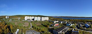
Luostari is a rural locality in Pechengsky District of Murmansk Oblast, Russia, located beyond the Arctic Circle at a height of 62 meters (203 ft) above sea level. Population: 10.
Shonguy is a rural locality under the administrative jurisdiction of the urban-type settlement of Kildinstroy in Kolsky District of Murmansk Oblast, Russia, located on the Kola Peninsula beyond the Arctic Circle. Population: 1,038.
Golubye Ruchyi is a rural locality under the administrative jurisdiction of the urban-type settlement of Kildinstroy in Kolsky District of Murmansk Oblast, Russia, located on the Kola Peninsula beyond the Arctic Circle at a height of 10 meters (33 ft) above sea level. Population: 447.
Zverosovkhoz is a rural locality under the administrative jurisdiction of the urban-type settlement of Kildinstroy in Kolsky District of Murmansk Oblast, Russia, located on the Kola Peninsula beyond the Arctic Circle. Population: 1,598.
Mokraya Kitsa is a rural locality in Pushnovsky Territorial Okrug of Kolsky District of Murmansk Oblast, Russia, located on the Kola Peninsula beyond the Arctic Circle. Population: 40.
Kitsa is a rural locality in Pushnovsky Territorial Okrug of Kolsky District in Murmansk Oblast, Russia, located on the Kola Peninsula beyond the Arctic Circle at a height of 180 meters (590 ft) above sea level. Population: 45.
Tuloma is a rural locality in Kolsky District of Murmansk Oblast, Russia, located beyond the Arctic Circle at a height of 20 meters (66 ft) above sea level. Population: 1,991.
Vostochny Kildin is a rural locality in Teribersky Territorial Okrug of Kolsky District of Murmansk Oblast, Russia, located on Kildin Island beyond the Arctic Circle at a height of 1 meter above sea level. Population: 4.
Mayak Tyuvagubsky was a rural locality in Teribersky Territorial Okrug of Kolsky District of Murmansk Oblast, Russia, located on the Kola Peninsula beyond the Arctic Circle at a height of 55 meters (180 ft) above sea level. Population: 0. Due to depopulation, it was abolished effective April 26, 2013.