Kewaunee County is a county located in the U.S. state of Wisconsin. As of the 2020 census, the population was 20,563. Its county seat is Kewaunee. The county was created in 1852 and organized in 1859. Its Menominee name is Kewāneh, an archaic name for a species of duck. Kewaunee County is part of the Green Bay, WI Metropolitan Statistical Area as well as the Green Bay-Shawano, WI Combined Statistical Area.

Door County is the easternmost county in the U.S. state of Wisconsin. As of the 2020 census, the population was 30,066. Its county seat is Sturgeon Bay.

Baileys Harbor is a town in Door County, Wisconsin, United States. The population was 1,003 at the 2000 census. The unincorporated community of Peninsula Center is located in the town. The census-designated place of Baileys Harbor is also located with the town.

Port Washington is the county seat of Ozaukee County, Wisconsin, United States. Located on Lake Michigan's western shore east of Interstate 43, the community is a suburb in the Milwaukee metropolitan area 27 miles (43 km) north of Milwaukee. The city's artificial harbor at the mouth of Sauk Creek was dredged in the 1870s and was a commercial port until the early 2000s. The population was 12,353 at the 2020 census.
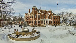
Sturgeon Bay is a city in and the county seat of Door County, Wisconsin, United States. The population was 9,646 at the 2020 census. Located at the bay of Sturgeon Bay for which it is named, it is the most-populous city on the Door Peninsula, a popular Upper Midwest vacation destination.

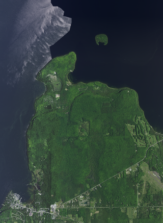
The Door Peninsula is a peninsula in eastern Wisconsin, separating the southern part of the Green Bay from Lake Michigan. The peninsula includes northern Kewaunee County, northeastern Brown County, and the mainland portion of Door County. It is on the western side of the Niagara Escarpment. Well known for its cherry and apple orchards, the Door Peninsula is a popular tourism destination. With the 1881 completion of the Sturgeon Bay Ship Canal, the northern half of the peninsula became an island.

The Baileys Harbor Range Lights are a pair of lighthouses arranged in a range light configuration, located near Baileys Harbor in Door County, Wisconsin, United States.

The Cana Island lighthouse is a lighthouse located just north of Baileys Harbor in Door County, Wisconsin, United States.

The Baileys Harbor lighthouse is a lighthouse located near Baileys Harbor in Door County, Wisconsin.
Peninsula State Park is a 3,776-acre (1,528 ha) Wisconsin state park with eight miles (13 km) of Green Bay shoreline in Door County. Peninsula is the third largest state park in Wisconsin and is visited by an estimated one million visitors annually.

Kangaroo Lake State Natural Area is a nature sanctuary in Door County, Wisconsin, United States, located on and around Kangaroo Lake. The land was designated a State Natural Area in 2002. Home to the endangered Hine's Emerald Dragonfly, it has the largest breeding population of the dragonfly in the world. The area also provides recreational activities for the public.

Wisconsin, a state in the Midwestern United States, has a vast and diverse geography famous for its landforms created by glaciers during the Wisconsin glaciation 17,000 years ago. The state can be generally divided into five geographic regions—Lake Superior Lowland, Northern Highland, Central Plain, Eastern Ridges & Lowlands, and Western Upland. The southwestern part of the state, which was not covered by glaciers during the most recent ice age, is known as the Driftless Area. The Wisconsin glaciation formed the Wisconsin Dells, Devil's Lake, and the Kettle Moraine. A number of areas are protected in the state, including Devil's Lake State Park, the Apostle Islands National Lakeshore, and the Chequamegon–Nicolet National Forest.

The Wisconsin State Natural Areas Program is a conservation program created to highlight and protect areas with outstanding natural or archaeological resources in the U.S. state of Wisconsin. There are currently 687 State Natural Areas (SNAs) encompassing almost 400,000 acres (160,000 ha). SNAs protect natural communities, geological formations, and archaeological sites for research purposes and as refuges for biodiversity and endangered or threatened species.

The Ridges Sanctuary is a 1,600-acre (650 ha) nature preserve and land trust in Baileys Harbor, Wisconsin. It is listed as a National Natural Landmark, Important Bird Area and Wisconsin State Natural Area. It was founded in 1937 and was the first land trust in the state.

Detroit Harbor is a bay between the southern end of Washington Island, and the northern end of Detroit Island. It is located in Washington, Door County, Wisconsin. An unincorporated community also named Detroit Harbor is found on the northern side of the bay. There are three islands inside of the bay, Snake Island, Big Susie Island, and Little Susie Island. The bay is dredged on either side to allow boats through, forming the East and West channels. Both car and passenger ferries to Washington Island go through Detroit Harbor, before they dock. The United States Coast Guard maintains operations in Detroit Harbor through the Washington Island Station. Detroit Harbor is designated as a Wisconsin state natural area by the Wisconsin Department of Natural Resources.

Pollution in Door County, Wisconsin relates to the degree of pollution in the air, water, and land in Door County, Wisconsin. Pollution is defined as the addition of any substance or any form of energy to the environment at a faster rate than it can be dispersed, diluted, decomposed, recycled, or stored in some harmless form.
The flora of Door County, Wisconsin comprise a variety of plant species. Geobotanically, Door County belongs to the North American Atlantic Region.

The climate of Door County, Wisconsin is tempered by Green Bay and Lake Michigan. There are fewer extremely cold days and fewer hot days than in areas of Wisconsin directly to the west. Lake waters delay the coming of spring as well as extend mild temperatures in the fall. Annual precipitation is slightly lower than elsewhere in northern Wisconsin. The county features a humid continental climate with warm summers and cold snowy winters.

The economy of Door County is similar to that of Bayfield, Iron, Oneida, Sawyer, and Vilas counties. These six northern Wisconsin counties have been categorized as having "forestry-related tourism"-based economies.


