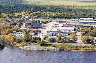
Moosonee is a town in northern Ontario, Canada, on the Moose River approximately 19 km (12 mi) south of James Bay. It is considered to be "the Gateway to the Arctic" and has Ontario's only saltwater port. Nearby on Moose Factory Island is the community of Moose Factory to which it is connected by water taxi in the summer and ice road in the winter.

The Kenogami River is a river in the James Bay drainage basin in Thunder Bay and Cochrane districts in Northern Ontario, Canada, which flows north from Long Lake near Longlac to empty into the Albany River. The river is 320 kilometres (199 mi) in length and its name means "long water" in the Cree language. A portion of the river's headwaters have been diverted into the Lake Superior drainage basin.

The Attawapiskat First Nation is an isolated First Nation located in Kenora District in northern Ontario, Canada, at the mouth of the Attawapiskat River on James Bay. The traditional territory of the Attawapiskat First Nation extends beyond their reserve up the coast to Hudson Bay and hundreds of kilometres inland along river tributaries. The community is connected to other towns along the shore of James Bay by the seasonal ice road/winter road constructed each December, linking it to the towns of Kashechewan First Nation, Fort Albany, and Moosonee Attawapiskat, Fort Albany, and Kashechewan operate and manage the James Bay Winter Road through the jointly owned Kimesskanemenow Corporation, named after the Cree word for "our road" -kimesskanemenow. Attawapiskat is the most remote northerly link on the 310 km (190 mi) road to Moosonee. They control the reserves at Attawapiskat 91 and Attawapiskat 91A.

The Hudson Bay Lowlands is a vast wetland located between the Canadian Shield and southern shores of Hudson Bay and James Bay. Most of the area lies within the province of Ontario, with smaller portions reaching into Manitoba and Quebec. Many wide and slow-moving rivers flow through this area toward the saltwater of Hudson Bay: these include the Churchill, Nelson and Hayes in Manitoba, Severn, Fawn, Winisk, Asheweig, Ekwan, Attawapiskat, and Albany in Ontario, and the Harricana, Rupert and Eastmain in Quebec. This is the largest wetland in Canada, and one of the largest in the world. The region can be subdivided into three bands running roughly northwest to southeast: the Coastal Hudson Bay Lowland, Hudson Bay Lowland, and James Bay Lowland.
The Attawapiskat River is a river in Kenora District in northwestern Ontario, Canada, that flows east from Attawapiskat Lake to James Bay. It is the third largest river entirely in Ontario.
The Streatfeild River is a river in Kenora District in Northwestern Ontario, Canada. It is a right tributary of the Attawapiskat River and its source is Streatfeild Lake, adjacent to the headwaters of the neighbouring Kapiskau River. The river lies in the Hudson Bay Lowlands and is part of the James Bay drainage basin.
The Ekwan River is a river in Kenora District in northwestern Ontario, Canada. It appears as Equam on Bellin map of 1744. Ekwan River is of Cree origin, meaning "the river far up the coast". It travels about 500 kilometres (311 mi) from its source at Zumar Lake on the Canadian Shield, through the Hudson Bay Lowlands, northeast and then east, to its mouth on James Bay.

The Montreal River is a river in Timiskaming District, Ontario, Canada. It travels 220 kilometres (137 mi) from its source at Smoothwater Lake to its mouth at Lake Timiskaming on the Ottawa River. The river is a significant source of hydroelectricity.

The Kapuskasing River is a river in the James Bay drainage basin in Cochrane District and Algoma District in northeastern Ontario, Canada. The river is a left tributary of the Mattagami River.
The Lawashi River is a river in Unorganized Kenora District in Northwestern Ontario, Canada. The river is a tributary of James Bay.
The Beaver River is a river in the far north of Kenora District in Northwestern Ontario, Canada. It is part of the Hudson Bay drainage basin, and is a left tributary of the Severn River.
The Beaver River is a river in the far northeast of Kenora District in Northwestern Ontario, Canada. It is part of the James Bay drainage basin, and is a left tributary of the Kapiskau River.
The Kesagami River is a river in northern Cochrane District in Northeastern Ontario, Canada. It is part of the James Bay drainage basin, and is a left tributary of the Harricana River. The lower two-thirds of the river, from about Kesagami Lake and downstream for 112 kilometres (70 mi) to its mouth, are part of Kesagami Provincial Park.
The Root River is a river in the Unorganized Part of Kenora District in Northwestern Ontario, Canada. The river is part of the Hudson Bay drainage basin, is a tributary of Lac Seul, and serves as the conduit for waters diverted from Lake St. Joseph, the source of the Albany River in the adjacent James Bay drainage basin.
The Atikameg River is a river in northeastern Kenora District in northwestern Ontario, Canada. It is in the James Bay drainage basin and is a right tributary of the Kapiskau River.
The Little Swan River is a river in northeastern Kenora District in northwestern Ontario, Canada. It is in the James Bay drainage basin and is a right tributary of the Atikameg River.
The North Wabassie River is a river in northeastern Kenora District in northwestern Ontario, Canada. It is in the James Bay drainage basin and is a right tributary of the Atikameg River.
The Cudmore Creek is a stream in northeastern Kenora District in northwestern Ontario, Canada. It is a tributary of James Bay.
The Muketei River is a river in northeastern Kenora District in northwestern Ontario, Canada. It is in the James Bay drainage basin and is a left tributary of the Attawapiskat River.
The Borden River is a river in Sudbury District in northeastern Ontario, Canada. It is in the James Bay drainage basin, and is a left tributary of the Nemegosenda River.
