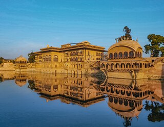
Deeg is an ancient historical city in Deeg district of Rajasthan, India. It is carved out from its former district bharatpur on 7 August 2023. It is situated 32 kilometres (20 mi) north of Bharatpur and 98 kilometres (61 mi) northwest of Agra.
Pindwara is a municipality and tehsil located, nearby Sirohi city in Sirohi District in the Indian state of Rajasthan. Pindwara is one of main financial city of Sirohi district after Abu Road. As of 2011, the population of Pindwara is 24,487. It is located 435 km (270 mi) southwest of the state capital, Jaipur, between Aravalli Hills and plains of Marwar region. The city used to be a major area of marble and stone carving in India for a long time. It is common belief that if there is any construction of temple work all over the world, it could not complete without involvement of Pindwara artisan. This is proved by this fact that marble carvings of major temples of India like Akshardham temple network, Shri Ram temple Ayodhya are being carried out in the city.

Agra is one of the 75 districts in the northern Indian state of Uttar Pradesh. The district headquarters is the historical city of Agra. Agra district is a part of Agra division.

Etah district is one of the districts of Uttar Pradesh, India, since 1854. Etah City is the district headquarters. Etah district is a part of Aligarh Division.
Nadbai is a city and a municipality in Bharatpur district in the Indian state of Rajasthan. Nadbai is administratively divided into Katra and Nadbai. It is also a subdivisional and tehsil headquarter in Bharatpur district.

Bharatpur District is a district in Rajasthan state in western India. The city of Bharatpur is the District Headquarters, Division Headquarters and Headquarters of Bharatpur
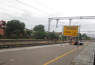
Palwal is a city and a municipal council. It is the headquarters of Palwal district, the 21st district of Haryana state in northern India. It is a centre of the cotton trade in the area. It is part of Braj region. It is also a part of National Capital Region.
Karauli District is a district of the state of Rajasthan in western India. It is located in the Braj Bhoomi region. The town of Karauli serves as the administrative headquarters of the district. Karauli district also comes under the Bharatpur Divisional Commissionerate.
Achhnera, is a town and a municipal board in Agra district in the Indian state of Uttar Pradesh.
Kherli is a city and a municipality in Alwar district in the Indian state of Rajasthan.Kherli mandi(Grain Market) is the second largest mandi in Rajasthan. Once upon a time it was so much famous that till now old jaipur people knows this as ganj kherli i.e. kherli mandi. Kherli is between the golden triangle where it is nearest to Agra(125 km) Jaipur(150 km) and Delhi(175 km).This area also comes under NCR but still they are not getting benefit of close proximity to these 3 big cities.
Kiraoli is a town and a nagar panchayat in Agra district in the Indian state of Uttar Pradesh.
Nagram is a town in Lucknow district, Uttar Pradesh, India. It is located between the two roads from Lucknow to Sultanpur and Raebareli.It was founded and named after Nalgram Raja,a Pasi king.
Shikohabad is a city and a municipal board in the Firozabad district of the Indian state of Uttar Pradesh.

Palwal district was created on 15 August 2008. It is the 21st district of Haryana state in Delhi NCR region of northern India. Palwal City is the headquarters of the district. It is part of the Braj region.

Newara is a village and a panchayat in the weir tehsil of the Bharatpur district in the state of Rajasthan, India. It is situated south-west of Bharatpur at a distance of about 37 km. Newara is situated 5 km away from the NH-11 road, between Jaipur and Agra.
Chhai Pokhar is a village in the district of Agra in the Indian state of Uttar Pradesh. It is nearby Achhnera or Achnera, connected by road on three sides of the village and by rail. Khera Sandhan is the nearest railway station at about 1 km from the village on Agra- Achnera-Mathura section of NW Railway. It is also known as Three Towers' Village.
Digrauta is a village in Uttar Pradesh state of India. It is located in the Agra district, and comes under the administration of Kheragarh panchayat. The population of the village is around 5000. The nearest major city is Agra (30 km).
Sahara is a village in Bichpuri Block in Agra District of Uttar Pradesh State, India. It belongs to Agra Division. It is located 13 km towards west from District headquarters Agra. 3 km from Bichpuri. 356 km from State capital Lucknow
Sarsai Nawar is a large village in the Etawah district of Uttar Pradesh, India. It is 329 kilometres (204 mi) south of the national capital New Delhi.

Tikla, or Tikula, is an archeological site and ancient rock shelter in Madhya Pradesh, India, known for its petroglyphs. Tikla is situated around 170 km (110 mi) south of Mathura and 50 km (31 mi) southwest of Gwalior on the Agra to Mumbai road near the town of Mohana on the right bank of the Parvati river.

