
The Miskitos are a native people in Central America. Their territory extends from Cape Camarón, Honduras, to Río Grande de Matagalpa, Nicaragua, along the Mosquito Coast, in the Western Caribbean zone. Their population is estimated at 700,000 people as of 2021, according to the official Miskito Database.

The North Caribbean Coast Autonomous Region is one of two autonomous regions in Nicaragua. It was created along with the South Caribbean Coast Autonomous Region by the Autonomy Statute of 7 September 1987 through a division of the former Zelaya Department. It covers an area of 33,106 km2 and has a population of 541,189. It is the largest autonomous region or department in Nicaragua. The capital is Puerto Cabezas. It contains part of the region known as the Mosquito Coast.
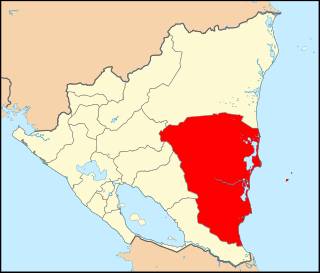
The South Caribbean Coast Autonomous Region is one of two autonomous regions in Nicaragua. It was created along with the North Caribbean Coast Autonomous Region by the Autonomy Statute of 7 September 1987 through a division of the former Zelaya Department. It covers an area of 27,260 km2 (10,530 sq mi) and has a population of 420,935. The capital is Bluefields. Bordering the Caribbean Sea, it contains part of the region known as Mosquitia.

Bluefields is the capital of the South Caribbean Autonomous Region in Nicaragua. It was also the capital of the former Kingdom of Mosquitia, and later the Zelaya Department, which was divided into North and South Caribbean Coast Autonomous Regions. It is located on Bluefields Bay at the mouth of the Bluefields River in the municipality of the same name.

The Misumalpan languages are a small family of languages spoken by indigenous peoples on the east coast of Nicaragua and nearby areas. The name "Misumalpan" was devised by John Alden Mason and is composed of syllables from the names of the family's three members Miskito, Sumo languages and Matagalpan. It was first recognized by Walter Lehmann in 1920. While all the languages of the Matagalpan branch are now extinct, the Miskito and Sumu languages are alive and well: Miskito has almost 200,000 speakers and serves as a second language for speakers of other indigenous languages in the Mosquito Coast. According to Hale, most speakers of Sumu also speak Miskito.
Mískito Coast Creole or Nicaraguan Creole English is an English-based creole language spoken in coastal Nicaraguan region of Mosquito Coast on the Caribbean Sea; its approximately 40,000 speakers are spread over the RAAN and RAAS regions of Nicaragua. The region, known before 1986 as the Zelaya department, is today administratively separated into two autonomous regions: North Caribbean Coast (RAAN) and South Caribbean Coast (RAAS). Mosquito is the nickname that is given to the region and earlier residents by early Europeans who visited and settled in the area. The term "Miskito" is now more commonly used to refer to both the people and the language.
Puerto Cabezas is a municipality and city in Nicaragua. It is the capital of Miskito nation in the North Caribbean Coast Autonomous Region.
San Juan de Nicaragua, formerly known as San Juan del Norte or Greytown, is a town and municipality in the Río San Juan Department of Nicaragua.
Paiwas is a municipality in the South Caribbean Coast Autonomous Region of Nicaragua. The administrative center is the town of Bocana de Paiwas.
El Tortuguero is a municipality in the South Caribbean Coast Autonomous Region of Nicaragua. It is located at about 530 km from Managua and can only be reached by an hour-long truck ride from El Rama.
La Cruz de Río Grande is a municipality in the South Caribbean Coast Autonomous Region of Nicaragua. According to the 2005 census, the population of La Cruz de Rio Grande was 3,000. It gets its name from the Rio Grande de Matagalpa which flows through it.
Kukra Hill(Loma de los Kukras) is a municipality in the South Caribbean Coast Autonomous Region in the Republic of Nicaragua. It was granted municipal status in 1989; before then, it was administratively part of the municipality of Bluefields, in the former department of Zelaya.

Pearl Lagoon is a municipality that is often time called just Lagoon and was historically known as English Bank. It is located in the South Caribbean Coast Autonomous Region of Nicaragua. It is the most important town of the largest coastal lagoon also by the name of Pearl Lagoon in the South Caribbean Coast Autonomous Region of Nicaragua and which the name of the town is derived from. As of 2022, Pearl Lagoon Municipality had a population of 21,360.

The Corn Islands are two islands about 70 kilometres (43 mi) east of the Caribbean coast of Nicaragua, constituting one of 12 municipalities of the South Caribbean Coast Autonomous Region of Nicaragua. The official name of the municipality is Corn Island.

The Mayangna are a people who live on the eastern coasts of Nicaragua and Honduras, an area commonly known as the Mosquito Coast. Their preferred autonym is Mayangna, as the name "Sumo" is a derogatory name historically used by the Miskito people. Their culture is closer to that of the indigenous peoples of Costa Rica, Panama, and Colombia than to the Mesoamerican cultures to the north. The Mayangna inhabited much of the Mosquito Coast in the 16th century. Since then, they have become more marginalized following the emergence of the Miskito as a regional power.
The following is an alphabetical list of topics related to Nicaragua.

The official language of Nicaragua is Spanish; however, Nicaraguans on the Caribbean coast speak indigenous languages and also English. The communities located on the Caribbean coast also have access to education in their native languages. Additionally, Nicaragua has four extinct indigenous languages.
Río Grande de Matagalpa is a river of Nicaragua. Running 430 kilometers (270 mi) from its source near Matagalpa to the Caribbean Sea in the northern part of the South Caribbean Autonomous Region it is the second longest river in Nicaragua. It gives it name to the city and municipality of La Cruz de Río Grande. The Tumarín Dam is being constructed on its lower reaches.

Afro-Nicaraguans are Nicaraguans of Sub-Saharan African descent. Five main distinct ethnic groups exist: The Creoles who descend from Anglo-Caribbean countries and many of whom still speak Nicaragua English Creole, the Miskito Sambus descendants of Spanish slaves and indigenous Central Americans who still speak Miskito and/or Miskito Coast Creole, the Garifunas descendants of Zambos expelled from St. Vincent who speak Garifuna, the Rama Cay zambos a subset of the Miskito who speak Rama Cay Creole, and the descendants of those enslaved by the Spanish.

Afro-Hondurans or Black Hondurans are Hondurans of Sub-Saharan African descent. Research by Henry Louis Gates and other sources regards their population to be around 1-2%. They descended from: enslaved Africans by the Spanish, as well as those who were enslaved from the West Indies and identify as Creole peoples, and the Garifuna who descend from exiled zambo Maroons from Saint Vincent. The Creole people were originally from Jamaica and other Caribbean islands, while the Garifuna people were originally from Saint Vincent and the Grenadines. Garifunas arrived in the late seventeen hundreds and the Creole peoples arrived during the eighteen hundreds. About 600,000 Hondurans are of Garífuna descent that are a mix of African and indigenous as of Afro Latin Americans. Honduras has one of the largest African community in Latin America.

