Kasbeer, Illinois

Last updated

Kasbeer, Illinois
20120128 42 Grain Elevator, Kasbeer, Illinois.jpg
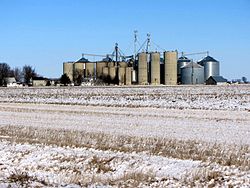
Kasbeer grain elevator
USA Illinois location map.svg
Red pog.svg
Kasbeer, Illinois
Usa edcp location map.svg
Red pog.svg
Kasbeer, Illinois
Coordinates: 41°30′18″N89°27′48″W / 41.50500°N 89.46333°W / 41.50500; -89.46333
Country United States
State Illinois
County Bureau
Elevation
741 ft (226 m)
Time zone UTC-6 (Central (CST))
  Summer (DST) UTC-5 (CDT)
ZIP code
61328 [1]
Area code(s) 815 & 779
GNIS feature ID411318 [2]

Kasbeer is an unincorporated community in Bureau County, Illinois, United States. Kasbeer is located along Illinois Route 26, north of Princeton and south of Ohio. The town of Kasbeer was originally begun 1/2-mile to the south of its current location, but formed when the railroad routed its tracks to the north. This small rural cornbelt town was named after Asa Kasbeer, a very successful farmer on that land, and his family. Currently, the town has only a Church and Post Office, other than its 30 houses and Grain Elevator; however, in an earlier time also had a two-building Grade School, General Store and gas station, barber shop, auto mechanic's garage, lumber yard, small cement block plant, television sales and service store, tavern, and for a short while a bank. Kasbeer is one of many small towns which is within the Princeton School District.

Related Research Articles

<span class="mw-page-title-main">Vermilion County, Illinois</span> County in Illinois, United States

Vermilion County is a county in the eastern part of the U.S. state of Illinois, between the Indiana border and Champaign County. It was established in 1826 and was the 45th of Illinois' 102 counties. According to the 2020 United States census, it had a population of 74,188. It contains 21 incorporated settlements; the county seat and largest city is Danville.

<span class="mw-page-title-main">Monroe County, Illinois</span> County in Illinois, United States

Monroe County is a county located in the U.S. state of Illinois. According to the 2020 census, it had a population of 34,962. Its county seat and largest city is Waterloo.

<span class="mw-page-title-main">Princeton, Illinois</span> City in Illinois, United States

Princeton is a city in and the county seat of Bureau County, Illinois, United States. The population was 7,832 at the 2020 census.

<span class="mw-page-title-main">Effingham, Illinois</span> City in Illinois, United States

Effingham is a city in and the county seat of Effingham County, Illinois, United States. It is in South Central Illinois. Its population was 12,252 at the 2020 census. The city is part of the Effingham, IL Micropolitan Statistical Area.

<span class="mw-page-title-main">Newton, Illinois</span> City in Illinois, United States

Newton is a city in and the county seat of Jasper County, Illinois, United States. The population was 2,849 at the 2010 census, down from 3,069 at the 2000 census. Newton is home to a large coal-fired power plant operated by Illinois Power Generating Co and is close to Newton Lake State Fish and Wildlife Area and Sam Parr State Fish and Wildlife Area.

<span class="mw-page-title-main">Algonquin, Illinois</span> Village in Illinois, United States

Algonquin is a village in McHenry and Kane counties, Illinois, in the United States. It is a suburb of Chicago, located approximately 40 miles (64 km) northwest of the Loop. As of the 2020 census, the village's population was 29,700.

<span class="mw-page-title-main">Mendota, Illinois</span> City in Illinois, United States

Mendota is a city in LaSalle County, Illinois, United States, in the state's north-central region. The population was 7,061 at the 2020 census. It is part of the Ottawa, IL Micropolitan Statistical Area. Mendota is located approximately 85 miles west of Chicago, 70 miles east of Moline and 55 miles south of Rockford. The current mayor is David W. Boelk, an independent elected to a four-year term.

<span class="mw-page-title-main">Sheridan, Illinois</span> Village in Illinois, United States

Sheridan is a village in LaSalle County, Illinois, United States. As of the 2020 census, the village's population was 2,431, up from 2,137 at the 2010 census. It is part of the Ottawa Micropolitan Statistical Area.

<span class="mw-page-title-main">Lake in the Hills, Illinois</span> Village in Illinois, United States

Lake in the Hills is a village in McHenry County, Illinois, United States. As of the 2020 census, the population was 28,982.

<span class="mw-page-title-main">Columbia, Illinois</span> City in Illinois, United States

Columbia is a city mainly in Monroe County with a small portion in St. Clair County in the U.S. state of Illinois, about 12 miles (19 km) south of St. Louis, Missouri. The population was 10,999 at the 2020 census.

<span class="mw-page-title-main">Chillicothe, Illinois</span> City in Illinois, United States

Chillicothe is a city on the Illinois River in Peoria County, Illinois, United States. The population was 6,097 at the 2010 census. Chillicothe is just north of the city of Peoria and is part of the Peoria Metropolitan Statistical Area.

<span class="mw-page-title-main">Princeton, Indiana</span> City in Indiana, United States

Princeton is the largest city in and the county seat of Patoka Township, Gibson County, Indiana, United States. The population was 8,301 at the 2020 United States Census, and it is part of the greater Evansville, Indiana, Metropolitan Area.

<span class="mw-page-title-main">Truro, Massachusetts</span> Town in Massachusetts, United States

Truro is a town in Barnstable County, Massachusetts, United States, comprising two villages: Truro and North Truro. Located slightly more than 100 miles (160 km) by road from Boston, it is a summer vacation community just south of the northern tip of Cape Cod, in an area known as the "Outer Cape". English colonists named it after Truro in Cornwall, United Kingdom.

<span class="mw-page-title-main">Atoka, Tennessee</span> Town

Atoka is a local government area with a town charter in Tipton County, Tennessee, United States. In 1888, Atoka was a stop on the Newport News & Mississippi Valley Railroad. Today the City of New Orleans Amtrak passenger train makes its daily route between New Orleans and Chicago, through Atoka. The population was 10,008 at the 2020 census, making the Town of Atoka the largest municipality in Tipton County.

<span class="mw-page-title-main">Cayce, Kentucky</span> Census-designated place in Kentucky, United States

Cayce is an unincorporated community and census-designated place (CDP) in Fulton County, Kentucky, United States, in the state's southwestern corner. As of the 2020 census it had a population of 119.

<span class="mw-page-title-main">Clyattville, Georgia</span> Census-designated place in Georgia, United States

Clyattville is an unincorporated community and census-designated place (CDP) in Lowndes County, Georgia, United States. It was established in the 1840s.

Ellery is an unincorporated community on the border of Edwards and Wayne counties in the U.S. state of Illinois. The eastern side lies in Edwards and the west side in Wayne; the county line runs down the main street.

<span class="mw-page-title-main">Putnam, Illinois</span> Unincorporated community in Illinois, United States

Putnam is an unincorporated community in Putnam County, Illinois, United States. The community is located to the west of Senachwine Lake along Illinois Route 29, north of Henry. This village of some 100 people was originally called Senachwine, after the great Indian Chief Senachwine.

Millburn is a former unincorporated community in Lake Villa Township and Newport Township, Lake County, Illinois, United States. Millburn is located at the junction of U.S. Route 45 and County Routes A10 and A14; it lies within the village of Old Mill Creek and borders Lindenhurst to the west. It is 5 miles (8 km) south of the Illinois-Wisconsin state border and 10 miles (16 km) west of Waukegan.

Limerick is an unincorporated community in Bureau County, Illinois, United States, located on Illinois Route 26, north of Princeton.

References

  1. "Kasbeer ZIP Code". zipdatamaps.com. 2022. Retrieved November 11, 2022.
  2. "US Board on Geographic Names". United States Geological Survey. October 25, 2007. Retrieved January 31, 2008.