Related Research Articles

The Liard River of the North American boreal forest flows through Yukon, British Columbia and the Northwest Territories, Canada. Rising in the Saint Cyr Range of the Pelly Mountains in southeastern Yukon, it flows 1,115 km (693 mi) southeast through British Columbia, marking the northern end of the Rocky Mountains and then curving northeast back into Yukon and Northwest Territories, draining into the Mackenzie River at Fort Simpson, Northwest Territories. The river drains approximately 277,100 km2 (107,000 sq mi) of boreal forest and muskeg.
The Kaska language is an endangered Athabaskan language. Traditionally, Kaska was an oral aboriginal language used by the Kaska Dena people. The Kaska Dene region consists of a small area in the Southwestern part of the Northwest Territories, the Southeastern part of Yukon Territory, and the Northern part of British Columbia. The communities that are in the Kaska Dene region are Fort Ware in N.W.T.; Ross River and Watson Lake in Y.T.; Dease Lake, Good Hope Lake, Lower Post, Fireside, and Muncho Lake in B.C. Kaska is made up of eight dialects, all of which have similar pronunciations and expressional terms. The town of Watson Lake was established around the period of the second World War when the Alaska Highway was built in 1942. A major consequence of colonization was Kaska language loss. Another major cause of Kaska language loss in Canada was due to the Canadian Residential School System. The effect that these schools had on the Kaska language have caused a language gap between two generations, resulting in few young speakers.

Sekani or Tse’khene are a First Nations people of the Athabaskan-speaking ethnolinguistic group in the Northern Interior of British Columbia. Their territory includes the Finlay and Parsnip River drainages of the Rocky Mountain Trench. The neighbours of the Sekani are the Babine to the west, Dakelh to the south, Dunneza (Beaver) to the east, and Kaska and Tahltan, to the north, all Athabaskan peoples. In addition, due to the westward spread of the Plains Cree in recent centuries, their neighbours to the east now include Cree communities.
The Tahltan or Nahani are a First Nations people of the Athabaskan-speaking ethnolinguistic group who live in northern British Columbia around Telegraph Creek, Dease Lake, and Iskut. The Tahltan constitute the fourth division of the Nahane.

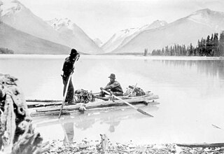
Robert Campbell was a Hudson's Bay Company fur trader and explorer. He explored a large part of the southern Yukon and northern British Columbia. He established the short-lived Dease Lake Post, and in 1838 he was the first European to reach the Stikine River overland. He established Fort Frances, Yukon on Frances Lake in the Liard River basin. In 1840 he crossed from Frances Lake to the Pelly River becoming the first European to explore the upper Yukon River Basin. He established Fort Selkirk, Yukon, at the juncture of the Yukon River and the Pelly River.
The Liard River First Nation, also known as the Liard First Nation is a First Nation in the southeastern Yukon in Canada. Its main centres are Upper Liard and Watson Lake along the Alaska Highway. The language originally spoken by the people of this First Nation was Kaska and the First Nation is a member of the Kaska Tribal Council which is pursuing land claims in the Yukon and northern British Columbia. Their Indian and Northern Affairs Canada band number is 502.

The Rocky Mountain Trench, also known as the Valley of a Thousand Peaks or simply the Trench, is a large valley on the western side of the northern part of North America's Rocky Mountains. The Trench is both visually and cartographically a striking physiographic feature extending approximately 1,600 km (1,000 mi) from Flathead Lake, Montana, to the Liard River, just south of the British Columbia–Yukon border near Watson Lake, Yukon. The trench bottom is 3–16 km (1.9–9.9 mi) wide and is 600–900 m (2,000–3,000 ft) above sea level. The general orientation of the Trench is an almost straight 150/330° geographic north vector and has become convenient as a visual guide for aviators heading north or south.

The Kechika River is a tributary of the Liard River, about 300 kilometres (190 mi) long, in northern British Columbia, Canada. The Kechika flows generally northwest through the northernmost section of the Rocky Mountain Trench before turning east to join the Liard, a major branch of the Mackenzie River system. The river's 22,700 km2 (8,800 sq mi) drainage basin is characterized by high glaciated peaks, boreal forest, and open tundra. With no settlements, roads or dams along its course, the Kechika is considered "one of British Columbia's finest examples of wilderness and undisturbed wildlife habitat."

The Dease River flows through northwestern British Columbia, Canada and is a tributary of the Liard River. The river descends from Dease Lake, though its ultimate origin is in the headwaters of Little Dease Creek at Snow Peak, approximately 50 kilometres (31 mi) west of the lake. The river flows 265 kilometres (165 mi) generally north-eastward, draining into the Liard River near Lower Post, British Columbia. Large sections of the river parallel the Cassiar Highway, helping to make it a popular destination for canoeists, kayakers, and rafters.
John McLeod was a Scottish-born explorer of Canada, in his capacity as a fur trader with the North West Company and Hudson's Bay Company. He was born at Valtos, Lochs in the Isle of Lewis. He is remembered primarily for his explorations of several major rivers of the southwestern Northwest Territories, southern Yukon Territory, and northern British Columbia.
Good Hope Lake is a First Nations community in northwestern British Columbia, Canada, located on Highway 37 not far south of the border with the Yukon and located east of the semi-abandoned mining town of Cassiar, British Columbia. As of the 2006 Census, there are 41 people living in Good Hope Lake, down from 75 in 2001. The band government of the Dease River First Nation is located in Good Hope Lake, and is a member government of the Kaska Tribal Council.
Lower Post is an aboriginal community in the Stikine Region of northern British Columbia, Canada, located on Highway 97, the Alaska Highway, approximately 15 miles southeast of Watson Lake, Yukon. Its historical mile designation is Mile 620. It is located near the confluence of the Dease and Liard Rivers.

The history of the Yukon covers the period from the arrival of Paleo-Indians through the Beringia land bridge approximately 20,000 years ago. In the 18th century, Russian explorers began to trade with the First Nations people along the Alaskan coast, and later established trade networks extending into Yukon. By the 19th century, traders from the Hudson's Bay Company were also active in the region. The region was administered as a part of the North-Western Territory until 1870, when the United Kingdom transferred the territory to Canada and it became the North-West Territories.

The Stikine Country, also referred to as the Stikine District or simply "the Stikine", is one of the historical geographic regions of the Canadian province of British Columbia, located inland from the central Alaska Panhandle and comprising the basin of the Stikine River and its tributaries. The term Stikine–Iskut is also fairly common to describe the area, and references the Iskut River, the Stikine's largest tributary and describable as its south fork.
Nahani is an Athabaskan word used to designate First Nations groups located in British Columbia, the Northwest Territories and Yukon between the upper Liard River and the 64th parallel north latitude. While these native groups do not necessarily have anything in common, the Canadian government used the term "Nahani" until the 1970s to refer to them collectively. The group term applied to several distinct tribes:
McDames Creek 2 is a Statistics Canada census designation for what is properly known as McDames Creek Indian Reserve No. 2, which flanks both sides of the Dease River at its confluence with McDame Creek in northwestern British Columbia, Canada. It was named for the 19th-century gold rush prospector Harry McDame. The reserve is under the administration of the Liard First Nation, a government of the Kaska Dena people and a member government of the Kaska Tribal Council.
The Kaska Dena Council is a tribal council formed of five band governments of the Kaska Dena people in northern British Columbia, Yukon Territory, and Northwest Territories, Canada.
The Dease River First Nation, also known as the Dease River Nation, is a band government of the Kaska Dena people in the Cassiar Country of the Northern Interior of British Columbia. Their offices are located in Good Hope Lake, British Columbia, which is on the Stewart-Cassiar Highway to the east of the abandoned mining town of Cassiar. The registered population of the band is 162.
Kaska Nation is a tribal council of First Nations in northern British Columbia, southern Yukon, and the southwestern Northwest Territories in Canada.

The Indigenous peoples of Yukon are ethnic groups who, prior to European contact, occupied the former countries now collectively known as Yukon. While most First Nations in the Canadian territory are a part of the wider Dene Nation, there are Tlingit and Métis nations that blend into the wider spectrum of indigeneity across Canada. Traditionally hunter-gatherers, indigenous peoples and their associated nations retain close connections to the land, the rivers and the seasons of their respective countries or homelands. Their histories are recorded and passed down the generations through oral traditions. European contact and invasion brought many changes to the native cultures of Yukon including land loss and non-traditional governance and education. However, indigenous people in Yukon continue to foster their connections with the land in seasonal wage labour such as fishing and trapping. Today, indigenous groups aim to maintain and develop indigenous languages, traditional or culturally-appropriate forms of education, cultures, spiritualities and indigenous rights.
References
- ↑ "Aboriginal Ancestry Responses (73), Single and Multiple Aboriginal Responses (4), Residence on or off reserve (3), Residence inside or outside Inuit Nunangat (7), Age (8A) and Sex (3) for the Population in Private Households of Canada, Provinces and Territories, 2016 Census - 25% Sample Data". www12.statcan.gc.ca. Government of Canada. October 25, 2017. Retrieved November 23, 2017.
- ↑ Farnell, G. (2014). The Kaska Dene: A study of Colonialism, Trauma and Healing in Dene Kēyeh. The University of British Columbia.
- ↑ Meek., A. B. (2010). We Are Our Language. An Ethnography of Language Revitalization in a Northern Athabaskan Community. Tucson, AZ: The University of Arizona Press. pp. 1–40.
- ↑ "One of Many". Film catalog. Doc Alliance Films. Retrieved April 14, 2013.