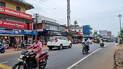
Keralapuram

Last updated

Keralapuram
Town
Keralapuram photo 1.jpg
Keralapuram
Coordinates: 8°56′27″N76°39′26″E / 8.94083°N 76.65722°E / 8.94083; 76.65722
CountryFlag of India.svg  India
State Kerala
District Kollam
Government
  TypePanchayath
  Body Kottamkara Panchayath, Perinad Panchayath
Languages
  Official Malayalam, English
Time zone UTC+5:30 (IST)
PIN
691014, 691504, 691577,691511
Telephone code0474
Vehicle registration KL-02
State Assembly constituency Kundara
Lok Sabha Constituency Kollam

Keralapuram is an suburban area in Kollam District of Kerala, India and a part of Kollam City. [1] Keralapuram is famous for numerous cashew factories in the region. It is split into Kottamkara Panchayath and Perinad Panchayath by the National Highway. In Kerala state legislative assembly elections, Keralapuram votes for Kundara Assembly constituency. [2]

Contents

History

Keralapuram lies in between Kollam City, and the historic trade hub Kundara. [3] The Kundara Proclamation by Velu Thampi Dalawa in the year 1809, which is considered to be one of the first events of freedom fight against the British Raj in Kerala, happened at a distance of 3 kilometers from the present day Keralapuram. First industries in Keralapuram are from the cashew industry boom of Kollam. [4]

Keralapuram has a Government High School that established in the year 1946 [5] and a Public Library established in the year 1948. [6] Another piece of history is the famous restaurant Ezhuthanikada Hotel, started by Meeran Saheb in 1948, which is now a local landmark. [7] The vettu cake of this restaurant is very popular across the state of Kerala [8] and among the Malayali diaspora in Middle East. [9] [10]

Location

Keralapuram is located on Kollam Tirumangalam National Highway at a distance of 10.5 km away from Kollam city and 3 km away from Kundara. A sizeable portion of the town falls on Kottamkara Panchayath on the East side of the highway, and remaining portion on Perinad Panchayath on the west side. It is also the junction where Ayoor Road, Mampuzha Road and Edavattom Road meets NH 744.[ citation needed ]

Thangal Kunju Musaliar College of Engineering (TKMCE), one of the premiere engineering institutes in Kerala, is located 4.3 kilometres from here at Karicode. [11]

Education

Hospitals

Banks / financial institutions

Places of worship

Keralapuram has numerous places of worship, some of them are listed.

Major industries

Keralapuram had several major cashew factories during the cashew boom of Kollam. Some of them are still in operation. [4]

Prominent persons

Some of the prominent persons hailing from the area include

See also

Related Research Articles

<span class="mw-page-title-main">Kollam</span> City in Kerala, India

Kollam, is an ancient seaport and the fourth largest city in the Indian state of Kerala. Located on the southern tip of the Malabar Coast of the Arabian Sea, the city is on the banks of Ashtamudi Lake and is 71 kilometers northwest of the state capital, Thiruvanathapuram (Trivandrum). Kollam is one of India's oldest continuously inhabited cities, with evidence of habitation stretching back to the megalithic; the city has also been a maritime entrepôt millennia, the earliest attestation of which dates back to the Phoenicians and Romans. It is the southern gateway to the Backwaters of Kerala, and is known for its cashew processing, coir manufacturing, and tourism industries.

<span class="mw-page-title-main">Kollam district</span> District in Kerala, India

Kollam district, is one of 14 districts of the state of Kerala, India. The district has a cross-section of Kerala's natural attributes; it is endowed with a long coastline, a major Laccadive Sea seaport and an inland lake. The district has many water bodies. Kallada River is one among them, and land on the east bank of the river is East Kallada and that on the west bank is West Kallada.

<span class="mw-page-title-main">Sooranad</span> Village in Kerala, India

Sooranad North is a village in Kollam district in the south west Indian state of Kerala. It is believed that Sooranad was ruled by King SOORAN and hence the name.

Karunagappally is a municipality in the Kollam district of Kerala, India. It is 24 km north of Kollam and 60 km (37 mi) south of Alappuzha. Karunagappally taluk consists of Alappad, Ochira, Adinad, Karunagappally, Thazhava, Pavumba, Thodiyoor, Kallalibhagom, Thevalakkara, Chavara, Neendakara, Clappana, Kulasekharapuram, Thekkumbhagam, Ayanivelikulangara, Panmana, Ponmana and Vadakumthala. The taluk is bound on the north by Kayamkulam, on the east by Kunnathur taluk, on the south by Kollam and on the west by the Arabian Sea. It is one of the fastest developing towns in Kerala and is part of Kollam metropolitan area.

Kundara is a satellite town in Kerala and is part of the Kollam Metropolitan Area, India. Kundara is situated at the eastern end of Kollam city. Kundara is significant for its historic involvement in the Indian independence movement.

<span class="mw-page-title-main">Anchalumoodu</span> Neighbourhood in Kollam district, Kerala, India

Anchalumoodu is a town and neighbourhood of the city of Kollam, India. It is a historic town near the place, where the Peruman railway accident happened in 1988. Anchalumoodu is 8 km away from Kollam city, 26 km from Paravur and 8 km from Kundara town. College of Engineering, Perumon is very close to this place. Anchalumoodu was a part of Thrikkadavoor till 2015. In May 2015, Government of Kerala have decided to expand City Corporation of Kollam by merging Thrikkadavoor panchayath. Now Anchalumoodu along with Thrikkadavoor is a part of Kollam city.

<span class="mw-page-title-main">Perinad</span> Village in Kerala, India

Perinad is a village in Kollam district in the state of Kerala, India. As of 2001 India census, Perinad had a population of 32,864 with 16,032 males and 16,832 females.

Poothakkulam, also known as Bhoothakkulam, is a village in Kollam district in the state of Kerala, India. The village is located 3.9 km away from Paravur, 11.4 km from Varkala and 23 km from Kollam. In 2011, it had a population of 628,451 residents. The village covers an area of 16.56 km2.

<span class="mw-page-title-main">Thrikkadavoor</span> Zone & Neighbourhood in Kollam district, Kerala, India

Thrikkadavoor is a town and a neighbourhood of Kollam city in the state of Kerala, India. It is located approximately 5 kilometres north of Kollam city centre and 30 kilometres away from Paravur, Thrikkadavoor has become a bustling urban center, and is now home to educational institutions, five star hotel, local business establishments and major recent real estate ventures
Thrikkadavoor was a separate panchayath till 2015. In May 2015, Government of Kerala have decided to expand City Corporation of Kollam by merging Thrikkadavoor panchayath.

<span class="mw-page-title-main">Chandanathope</span> Town in Kerala, India

Chandanathope is a town located in Kollam district, Kerala. It lies 23 kilometres (14 mi) from Paravur town and 8 kilometres (5.0 mi) from Kollam city centre on the Kollam–Thirumangalam National Highway 744. In Malayalam, the name denotes a place with sandalwood plantations. It is also known for cashew processing and its exports two major cashew exporters of Kollam namely VLC Cashews and MARK has their facilities in the town.

Hinduism, Islam and Christianity are the prominent religions in Kollam district. As per the Census 2011, out of the total population of 2,635,375 persons, 64.42% follow Hinduism, 19.30% follow Islam and 16.00% follow Christianity. Other religions comprise 0.04%, while 0.25% did not state any religion.

<span class="mw-page-title-main">Punthalathazham</span> Neighbourhood in Kollam, Kerala, India

Punthalathazham is a landlocked neighbourhood of the city of Kollam in the Indian state of Kerala. It is located around six kilometres east of the core Kollam (Quilon) city towards Kannanalloor . This place has a little geographical importance and serves as the tail boundary of Kollam Municipal Corporation. Inhabitants belong to working and middle classes.

<span class="mw-page-title-main">Ithikkara</span> Village in Kerala, India

Ithikkara is a place in Kollam district, Kerala, India, about 12 km from Kollam city. It received its name from Ithikkara River.

<span class="mw-page-title-main">Thattamala</span> Neighbourhood in Eravipuram, Kollam, India

Thattamala is a neighbourhood situated at the southeast border of Kollam city in state of Kerala, India. It is situated at National Highways – NH 66. Kerala Police have identified Thattamala as one of the traffic black spots in the state.

<span class="mw-page-title-main">Transport in Kollam</span>

Transport in Kollam includes various modes of road, rail and water transportation in the city and its suburbs. State-owned Kerala State Road Transport Corporation buses, private buses, Indian Railways, state-owned Kerala State Water Transport Department boats & ferry, taxis and auto rickshaws are serving the city of Kollam. The city had a strong commercial reputation since the days of the Phoenicians and Romans. Ibn Battuta mentioned Kollam Port as one of the five Indian ports he had seen during the course of his twenty-four year travels.

<span class="mw-page-title-main">J. Mercykutty Amma</span> Indian politician

J. Mercykutty Amma is an Indian politician and she was the Minister for Fisheries, Harbour Engineering, Cashew Industry & Fisheries University, Government of Kerala from 2016 to 2021. She represented Kundara constituency in Kollam, Kerala three times in her political career.

<span class="mw-page-title-main">Kundara Assembly constituency</span> Constituency of the Kerala legislative assembly in India

Kundara is a legislative assembly constituency in Kollam district of Kerala, India. It is one among the 11 assembly constituencies in Kollam district. As of the 2021 assembly elections, the current MLA is P. C. Vishnunath of INC.

Vellimon is a village situated in Perinad panchayath of Kollam district in Kerala, India. It is situated around 13 km away from district headquarters. Vellimon is a peninsular landmass of laterite soil that is protruding into Ashtamudi lake the peninsula is having a 20 metre high nearly continuous cliff facing backwaters. Farming, fishing and coir manufacturing are major activity in Vellimon. Chief cropping in the area is coconut. The population is overwhelmingly Hindus and there is visible lack of entrepreneurship and organised activities in the area. There were two resorts that came up in Vellimon namely Snehatheeram and Cambay Palm Lagoon. Due to lack of co-operation and anti social activities from local communities both were forced to shut down. Cambay Palm Lagoon was situated in the scenic laterite cliff that overlooks Munroe Island this resort is currently vandalised by miscreants.

References

  1. "Location of Keralapuram".
  2. "Polling Booths in Kundara Assembly".
  3. "History of Kollam".
  4. 1 2 "Large Industrial Establishments in India". 1958.
  5. "About GHS KERALAPURAM". schools.org.in. Retrieved 21 March 2021.
  6. "Kerapuram Public Library". in.worldorgs.com.
  7. "Try special mutton and cake combo at Ezhuthani Hotel in Kollam". OnManorama. Retrieved 12 May 2020.
  8. "The Kollam food circuit can be a fine mix of old and new". OnManorama. Retrieved 12 May 2020.
  9. Nagarajan, Saraswathy (18 April 2019). "Vettu cake from Keralapuram in Kollam is a 'cut' above the rest". The Hindu. ISSN   0971-751X . Retrieved 19 May 2020.
  10. Daily, Keralakaumudi. "ദിവസവും അയ്യായിരം വെട്ടുകേക്കുകൾ എവിടെ പോകുന്നു ? ഗൾഫ്നാടുകളിലും അമേരിക്കയിലും വരെ പ്രശസ്തമായ എഴുത്താണി കേക്ക്". Keralakaumudi Daily. Retrieved 12 May 2020.
  11. "Keralapuram, Kollam,kerela to TKM College of Engineering".
  12. http://stvincentskeralapuram.com/
  13. "State Bank Of India Keralapuram Kollam Branch IFSC/MICR Code Details" . Retrieved 7 September 2020.
  14. "Indian Bank Keralapuram Kollam Branch IFSC/MICR Code Details" . Retrieved 7 September 2020.
  15. "Veteran Malayalam actor Kainakary Thankaraj passes away at 77". 4 April 2022.
  16. "നാടക നടനും സംവിധായകനുമായ കേരളപുരം കലാം അന്തരിച്ചു". 15 November 2018.