Related Research Articles

Delta Electricity is an electricity generation company in Australia. The company was formed by the Government of New South Wales in 1996 as part of its reform of the electricity sector in the State, which saw the breakup of the Electricity Commission of New South Wales. Delta Electricity, which at the time owned only the Vales Point Power Station, was sold to Sunset Power International for $1 million in November 2015 and was valued at $730 million 2 years later. It has a portfolio of generating sites mainly using thermal coal power.
Marrangaroo is a village in the Central West of New South Wales, Australia in the City of Lithgow. The name is also applied to the surrounding area, for postal and statistical purposes.
Torbanite, also known historically as boghead coal or kerosene shale, is a variety of fine-grained black oil shale. It usually occurs as lenticular masses, often associated with deposits of Permian coals. Torbanite is classified as lacustrine type oil shale. A similar mineral, cannel coal, is classified as being a terrestrial form of oil shale, not a lacustrine type.

Joadja is a historic town, now in ruins, in the Southern Highlands of New South Wales, Australia, in Wingecarribee Shire. The remnants of the town were added to the New South Wales State Heritage Register on 5 November 1999.

Hartley Vale is a small village in the Blue Mountains area of New South Wales, Australia. It is approximately 150 kilometres west of Sydney and 12 kilometres south-east of Lithgow. It is in the local government area of the City of Lithgow.

Little Hartley is a village in the Central West region of New South Wales, Australia. It is located approximately 150 kilometres west-northwest of Sydney and 20 kilometres south-east of Lithgow, on the Great Western Highway. It is in the local government area of the City of Lithgow.
The Nevada–Texas–Utah retort process was an above-ground shale oil extraction technology to produce shale oil, a type of synthetic crude oil. It heated oil shale in a sealed vessel (retort) causing its decomposition into shale oil, oil shale gas and spent residue. The process was developed in the 1920s and used for shale oil production in the United States and in Australia. The process was simple to operate; however, it was ceased from the operation because of a small capacity and labor extensiveness.

Wallerawang is a small township in the Central Tablelands of New South Wales, Australia. It is located approximately 14 kilometres (8.7 mi) northwest of Lithgow adjacent to the Great Western Highway. It is also located on the Main Western railway line at the junction of the Gwabegar line. The name is also applied to the surrounding area for postal and statistical purposes.
There are oil shale deposits in Australia which range from small deposits to large reserves. Deposits, varying by their age and origin, are located in about a third of eastern Australia. In 2012, the demonstrated oil shale reserves were estimated at 58 billion tonnes. The easiest to recover deposits are located in Queensland.

The Glen Davis Shale Oil Works was a shale oil extraction plant, in the Capertee Valley, at Glen Davis, New South Wales, Australia, which operated from 1940 until 1952. It was the last oil-shale operation in Australia, until the Stuart Oil Shale Project in the late 1990s. For the period of 1965–1952, it provided one fifth of the shale oil produced in Australia.
Commonwealth Oil Corporation Limited was a British-owned Australian company associated with the production and refining of petroleum products derived from oil shale, during the early years of the 20th century. It is associated with Newnes, Hartley Vale, and Torbane, all in New South Wales. It should not be confused with Commonwealth Oil Refineries, which was a completely separate company, established in 1920, that refined imported crude oil from 1924.
Clandulla is a village in New South Wales, Australia, within the Mid-Western Regional Council, about 225 kilometres north-west of Sydney. At the 2016 census Clandulla and the surrounding rural district had a population of 197, living in 61 private dwellings. The township and district also included 22 unoccupied private dwellings. Clandulla is bounded to the west and north by the Clandulla State Forest.
Torbane was a privately-owned village lying within the area now known as Capertee, in the Local Government Area of the City of Lithgow, within the Central West region of New South Wales, Australia. There was also another village, Airly, nearby. Both villages were associated with the mining of oil shale. The mine associated with Torbane was known as the New Hartley Mine. and that associated with Airly was known as the Genowlan Mine. There were retorts that produced crude shale oil at Torbane. Both Torbane and Airly are now ghost towns.

John Wilson Fell (1862–1955) was an industrialist involved in the shale oil operations at Newnes, New South Wales and the establishment of two early oil refineries, on Gore Bay at Greenwich and at Clyde, both suburbs of Sydney. He was the principal of John Fell & Company and was, for many years, the Managing Director of Commonwealth Oil Corporation, which he revived from receivership.
The British Australian Oil Company Limited was a British-owned company—incorporated in 1910—that mined oil shale and produced shale oil and refined oil products, in New South Wales, Australia, during the years from 1911 to 1915.
Baerami Creek is a locality in the Muswellbrook Shire in the Upper Hunter region of New South Wales, Australia. Part of the locality lies in a part of the valley of the watercourse of the same name, Baerami Creek.
The New South Wales Shale and Oil Company — established in 1872, by the merging of two earlier ventures — mined and processed oil shale to produce kerosene, paraffin wax and candles, and other petroleum products, in New South Wales Australia. It is particularly associated with the sites of its former works, at Hartley Vale and Torbane. Its assets were bought by Commonwealth Oil Corporation in 1906.
Australian Kerosene Oil Company or 'A.K.O' mined and processed oil shale to produce kerosene, paraffin wax and candles, lubricating oil and greases, and other petroleum-based products, in New South Wales Australia. It is particularly associated with the site of its mine and works, at Joadja. At times, it also had other mining operations, at Airly and near Katoomba, and a soap and candle factory at Camellia. The company used the brand name 'Southern Cross' for its kerosene products.
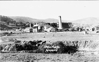
Lidsdale is a locality within the City of Lithgow Local Government Area of New South Wales, Australia. It lies to the north of Wallerawang. Its area, as defined for postal and statistical purposes, includes the historic locality of Kerosene Vale and the small rural areas known as Springvale and Angus Place. In 2021, its population was 471.
References
- ↑ "GEOGRAPHICAL NAMES ACT 1966". Government Gazette of the State of New South Wales . 11 July 1997. p. 5476. Retrieved 5 June 2022.
- 1 2 3 4 "Kerosene Vale". www.bushexplorers.com.au. Retrieved 5 June 2022.
- ↑ "Search Census data | Australian Bureau of Statistics - Lidsdale NSW". abs.gov.au. Retrieved 5 June 2022.
- ↑ "Lidsdale · New South Wales 2790, Australia". Google Maps. Retrieved 5 June 2022.
- ↑ "GEOGRAPHICAL NAMES ACT, 1966". Government Gazette of the State of New South Wales . 24 April 1975. p. 1629. Retrieved 5 June 2022.
- ↑ Australian Institute of Aboriginal and Torres Strait Islander Studies (25 May 2022). "Map of Indigenous Australia". aiatsis.gov.au. Retrieved 5 June 2022.
- 1 2 "Geological map (with sections) showing position of kerosene shale seam at Marangaroo, Kerosene Vale or Bathgate". Trove. Retrieved 5 June 2022.
- 1 2 "MACKENZIE AND BROS. KEROSENE WORKS". Maitland Mercury and Hunter River General Advertiser . 15 January 1867. p. 3. Retrieved 5 June 2022.
- 1 2 "TOWN AND COUNTRY, Kerosene Vale Oil Works". Sydney Mail . 1 June 1867. p. 2. Retrieved 5 June 2022.
- ↑ "THE UNDERGROUND PERMANENT WEALTH OP NEW SOUTH WALES". Illustrated Sydney News and New South Wales Agriculturalist and Grazier . 27 September 1873. p. 6. Retrieved 7 August 2023.
- ↑ "MOUNT VICTORIA". Illustrated Sydney News and New South Wales Agriculturalist and Grazier . 22 November 1873. p. 21. Retrieved 5 June 2022.
- ↑ "Marrangaroo Tunnel (1st)". nswrail.net. Retrieved 8 June 2022.
- ↑ "SEVERANCE OF LINK WITH EARLY MINING HISTORY". Lithgow Mercury . 12 June 1952. p. 4. Retrieved 13 June 2022.
- ↑ "PICNIC NEAR LIDSDALE". Lithgow Mercury . 3 February 1899. p. 3. Retrieved 13 June 2022.
- ↑ "WALLERAWANG". Lithgow Mercury . 14 February 1935. p. 3. Retrieved 13 June 2022.
- ↑ "2LT YOUNGER SET COMBINED PICNIC". Lithgow Mercury . 17 April 1947. p. 5. Retrieved 13 June 2022.
- ↑ "Modern Colliery To Operate At Kerosene Vale". Lithgow Mercury . 18 October 1949. p. 2. Retrieved 5 June 2022.
- ↑ "Machines are winning us more coal". Daily Telegraph . 16 December 1950. p. 3. Retrieved 5 June 2022.
- ↑ "Open-Cut Record—Kerosene Vale Yields 3905 Tons". Newcastle Morning Herald and Miners' Advocate . 22 March 1951. p. 3. Retrieved 5 June 2022.
- ↑ "RIVAL COMPANIES TRY TO TAKE OVER OPEN CUT". Sun . 20 July 1952. p. 3. Retrieved 5 June 2022.
- ↑ "Open-cut Equipment Is Hard To Sell". Lithgow Mercury . 15 October 1954. p. 8. Retrieved 5 June 2022.
- ↑ Parsons Brinckerhoff (April 2008). "Stage 2 - Kerosene Vale Ash Repository Area, Environmental Assessment" (PDF).
- ↑ "33°22'59.4"S 150°05'43.5"E · Lidsdale NSW 2790, Australia - Satellite View". Google Maps. Retrieved 5 June 2022.
- ↑ Brown, Jim (1987). Bent Backs, An illustrates social and technological history of the Western Coal Field. Lithgow: Industrial Printing Co. pp. 144, 145.
33°22′59″S150°05′44″E / 33.38306°S 150.09556°E
| | This Central West geography article is a stub. You can help Wikipedia by expanding it. |