Lidsdale

Last updated
Lidsdale
New South Wales
Australia New South Wales relief location map.png
Red pog.svg
Lidsdale
Lidsdale
Coordinates 33°23′24″S150°05′05″E / 33.390028°S 150.084586°E / -33.390028; 150.084586
Population471 (2021)
Postcode(s) 2790
Location
LGA(s) City of Lithgow
Region Central Tablelands
County Australia
State electorate(s) Bathurst
Federal division(s) Calare
Localities around Lidsdale:
Cullen Bullen Wolgan Valley
Blackmans FlatLidsdale
Mount Lambie Wallerawang Marrangaroo

Lidsdale is a locality within the City of Lithgow Local Government Area of New South Wales, Australia. It lies to the north of Wallerawang. Its area, as defined for postal and statistical purposes, includes the historic locality of Kerosene Vale and the small rural areas known as Springvale and Angus Place. In 2021, its population was 471. [1]

The area that later became known as Lidsdale lies close to the easternmost extent of the traditional lands of Wiradjuri people. [2] There are culturally significant sites within the locality. [3]

A village developed as a stopping place on the road to Mudgee during the gold rushes. It soon had at least two inns, the Carriers Arms and the Square and Compass Inn, also a livery stable and blacksmith's shop. [4]

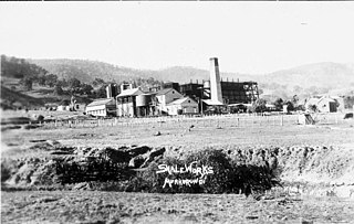
Coal mining began in the area, in 1893, when the Folly mine was opened by John Maddox, a son of the owner of the Carrier's Arms inn, Thomas Maddox. [5] [6] Coal mining still takes place in Lidsdale. [7] There was also a short-lived oil shale mining, retorting and shale oil refining operation, in the part of the locality that was formerly known as Kerosene Vale, beginning in 1867. [8] [9] [10]

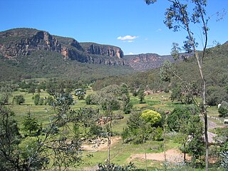
Most of the settled area of the locality is in the mainly-cleared valley of Coxs River. At the southern end, is the small village, centred on Wolgan Road, which is now an area of mixed industrial and residential use. The southern boundary of the locality borders the site of the former Wallerawang Power Station. [11] There are two coal mines, Angus Place mine (closed) [12] and Springvale mine. [7] There is a large ash dam and dry ash dump, in the part of the locality that was formerly known as Kerosene Vale. [13] [14] The locality extends north to the Wolgan Gap, the location where Wolgan Road descends into the Wolgan Valley, and to part of the valley's rim. Most of the eastern part of the locality is forested and mountainous. [11]

In the past, the village area in the south of the locality lay on the main road between Lithgow and Mudgee, which intersected Wolgan Road, [15] but the Castlereagh Highway now bypasses it, where it runs across the south-western part of the locality. Part of the former Wallerawang Colliery Branch Railway ran through the locality and serviced the Angus Place mine. [16] The Main Western railway line passes across the south-east part of the locality, in the area known as Springvale. [17]

Lidsdale had a post office, which opened in 1871, originally as Wallerawang, and was renamed Lidsdale, in 1873, after another post office opened closer to the Wallerawang railway station and township. The existing building opened in 1912; it closed in November 1991, and subsequently has been converted to holiday accommodation. [18] It had a school for most of the time between August 1870 and June 1936, and again January 1963 between May 1975; the school was known as Lidsdale only between 1900 and 1936 and otherwise mainly used the name Blackmans Flat. [19]

Related Research Articles

<span class="mw-page-title-main">Wolgan Valley</span> Small valley in New South Wales

Wolgan Valley is a small valley located along the Wolgan River in the Lithgow Region of New South Wales, Australia. The valley is located approximately 32 kilometres (20 mi) north of Lithgow and 150 kilometres north-west of Sydney. Accessible by the Wolgan Valley Discovery Trail from the Castlereagh Highway, the road travels through the valley leading onto the historical village of Newnes and its extensive industrial ruins.

<span class="mw-page-title-main">Glen Davis, New South Wales</span> Town in New South Wales, Australia

Glen Davis is a village in the Central Tablelands of New South Wales, Australia. The village is located in the local government area of the City of Lithgow. It is located 250 km north-west of Sydney and approximately 80 kilometres north of Lithgow. In the 2006 census, Glen Davis had a population of 354 but this fell to 115 in the 2016 census.

<span class="mw-page-title-main">Rylstone, New South Wales</span> Town in New South Wales, Australia

Rylstone is a small town in New South Wales, Australia, in the Central Tablelands region within the Mid-Western Regional Council local government area. It is located on the Bylong Valley Way road route. At the 2021 census, Rylstone had a population of 904.

Kandos is a small town in the Central Tablelands of New South Wales, Australia, within the Mid-Western Regional Council. The area is the traditional home of the Dabee tribe of the Wiradjuri people. The town sits beneath Cumber Melon Mountain, in a district formerly known as Coomber. Kandos shares its locality, employment and infrastructure with the neighbouring town Rylstone, 6 kilometres away. At the 2021 census, Kandos had a population of 1263.

<span class="mw-page-title-main">City of Lithgow</span> Local government area in New South Wales, Australia

The City of Lithgow is a local government area in the Central West region of New South Wales, Australia. The area is located adjacent to the Great Western Highway and the Main Western railway line.

<span class="mw-page-title-main">Gwabegar railway line</span>

The Gwabegar railway line is a railway line in the Central West and North West Slopes of New South Wales, Australia, which passes through the towns of Mudgee, Gulgong, Dunedoo, Coonabarabran and terminates at Gwabegar.

Tallawang is an historical locality north of Gulgong in central western New South Wales, Australia. The place name is derived from an aboriginal word for "apple gum".

<span class="mw-page-title-main">Hartley Vale, New South Wales</span> Town in New South Wales, Australia

Hartley Vale is a small village in the Blue Mountains area of New South Wales, Australia. It is approximately 150 kilometres west of Sydney and 12 kilometres south-east of Lithgow. It is in the local government area of the City of Lithgow.

<span class="mw-page-title-main">Capertee Valley</span>

The Capertee Valley is a large canyon in New South Wales, Australia, 135 km (84 mi) north-west of Sydney that is noted to be the second widest of any canyon in the world, exceeding The Grand Canyon. It is located 135 km (84 mi) kilometres north-west of Sydney, between Lithgow and Mudgee, in the Central Tablelands, just above the Blue Mountains.

<span class="mw-page-title-main">Wallerawang</span> Town in New South Wales, Australia

Wallerawang is a small township in the Central Tablelands of New South Wales, Australia. It is located approximately 14 kilometres (8.7 mi) northwest of Lithgow adjacent to the Great Western Highway. It is also located on the Main Western railway line at the junction of the Gwabegar line.

÷Some of the more notable coal companies in Australia are the following:

Kerosene Vale is a historic locality within the City of Lithgow Local Government Area of New South Wales, Australia. Kerosene Vale lies near Lidsdale and Wallerawang. It is considered part of Lidsdale for census purposes. It should not be confused with Hartley Vale, another locality with a history of shale oil production, which is also within the City of Lithgow. The name Kerosene Vale is now only used infrequently.

<span class="mw-page-title-main">Glen Davis Shale Oil Works</span> Oil extraction plant

The Glen Davis Shale Oil Works was a shale oil extraction plant, in the Capertee Valley, at Glen Davis, New South Wales, Australia, which operated from 1940 until 1952. It was the last oil-shale operation in Australia, until the Stuart Oil Shale Project in the late 1990s. For the period of 1965–1952, it provided one fifth of the shale oil produced in Australia.

Clandulla is a village in New South Wales, Australia, within the Mid-Western Regional Council, about 225 kilometres north-west of Sydney. At the 2016 census Clandulla and the surrounding rural district had a population of 197, living in 61 private dwellings. The township and district also included 22 unoccupied private dwellings. Clandulla is bounded to the west and north by the Clandulla State Forest.

Torbane was a privately-owned village lying within the area now known as Capertee, in the Local Government Area of the City of Lithgow, within the Central West region of New South Wales, Australia. There was also another village, Airly, nearby. Both villages were associated with the mining of oil shale. The mine associated with Torbane was known as the New Hartley Mine. and that associated with Airly was known as the Genowlan Mine. There were retorts that produced crude shale oil at Torbane. Both Torbane and Airly are now ghost towns.

<span class="mw-page-title-main">John Fell (industrialist)</span> Scottish-born Australian industrialist

John Wilson Fell (1862–1955) was an industrialist involved in the shale oil operations at Newnes, New South Wales and the establishment of two early oil refineries, on Gore Bay at Greenwich and at Clyde, both suburbs of Sydney. He was the principal of John Fell & Company and was, for many years, the Managing Director of Commonwealth Oil Corporation, which he revived from receivership.

<span class="mw-page-title-main">British Australian Oil Company</span> Former shale oil company of Australia

The British Australian Oil Company Limited was a British-owned company—incorporated in 1910—that mined oil shale and produced shale oil and refined oil products, in New South Wales, Australia, during the years from 1911 to 1915.

The New South Wales Shale and Oil Company — established in 1872, by the merging of two earlier ventures — mined and processed oil shale to produce kerosene, paraffin wax and candles, and other petroleum products, in New South Wales Australia. It is particularly associated with the sites of its former works, at Hartley Vale and Torbane. Its assets were bought by Commonwealth Oil Corporation in 1906.

Australian Kerosene Oil Company or 'A.K.O' mined and processed oil shale to produce kerosene, paraffin wax and candles, lubricating oil and greases, and other petroleum-based products, in New South Wales Australia. It is particularly associated with the site of its mine and works, at Joadja. At times, it also had other mining operations, at Airly and near Katoomba, and a soap and candle factory at Camellia. The company used the brand name 'Southern Cross' for its kerosene products.

References

  1. "2021 Lidsdale, Census All persons QuickStats | Australian Bureau of Statistics". www.abs.gov.au. Retrieved 15 August 2023.
  2. Studies, Australian Institute of Aboriginal and Torres Strait Islander (25 May 2022). "Map of Indigenous Australia". aiatsis.gov.au. Retrieved 5 June 2022.
  3. "Black Fellows Hands Reserve (Maiyingu Marragu) | Lithgow Tourism Information". 22 September 2017. Retrieved 15 August 2023.
  4. "HISTORICAL SUMMARY". lithgow-tourism.com. Retrieved 16 August 2023.
  5. "LIDSDALE COAL AND SHALE". Lithgow Mercury . 24 January 1923. p. 1. Retrieved 18 August 2023.
  6. "FOLLY COLLIERY". New South Wales Government Gazette . 8 February 1895. p. 846. Retrieved 18 August 2023.
  7. 1 2 "Springvale coal mine". Global Energy Monitor. 13 June 2022. Retrieved 15 August 2023.
  8. "Geological map (with sections) showing position of kerosene shale seam at Marangaroo, Kerosene Vale or Bathgate". Trove. Retrieved 5 June 2022.
  9. "MACKENZIE AND BROS. KEROSENE WORKS". Maitland Mercury and Hunter River General Advertiser . 15 January 1867. p. 3. Retrieved 5 June 2022.
  10. "TOWN AND COUNTRY, Kerosene Vale Oil Works". Sydney Mail . 1 June 1867. p. 2. Retrieved 5 June 2022.
  11. 1 2 "Satellite View - Lidsdale · New South Wales 2790, Australia". Google Maps. Retrieved 16 August 2023.
  12. "Angus Place Colliery". Global Energy Monitor. 31 March 2023. Retrieved 15 August 2023.
  13. "Kerosene Vale". www.bushexplorers.com.au. Retrieved 5 June 2022.
  14. Parsons Brinckerhoff (April 2008). "Stage 2 - Kerosene Vale Ash Repository Area, Environmental Assessment" (PDF).
  15. "Blue Mountains and Burragorang Valley tourist map [cartographic material]". Trove. Retrieved 15 August 2023.
  16. "Wallerawang Colliery Branch". www.nswrail.net. Retrieved 15 August 2023.
  17. "Relation: ‪Lidsdale‬ (‪6044563‬)". OpenStreetMap. Retrieved 25 August 2023.
  18. "The Old Postie, Lidsdale - Wolgan Valley". Wolgan Valley Association. Retrieved 15 August 2023.
  19. "Lidsdale". nswgovschoolhistory.cese.nsw.gov.au. Retrieved 15 August 2023.