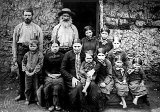
Boers are the descendants of the proto Afrikaans-speaking Free Burghers of the eastern Cape frontier in Southern Africa during the 17th, 18th, and 19th centuries. From 1652 to 1795, the Dutch East India Company controlled the Dutch Cape Colony, which the United Kingdom incorporated into the British Empire in 1806. The name of the group is derived from Trekboer then later "boer", which means "farmer" in Dutch and Afrikaans.
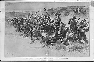
The Jameson Raid was a botched raid against the South African Republic carried out by British colonial administrator Leander Starr Jameson, under the employment of Cecil Rhodes. It involved 500 British South Africa Company police and was launched from Rhodesia over the New Year weekend of 1895–96. Paul Kruger, for whom Rhodes had great personal hatred, was president of the South African Republic at the time. The raid was intended to trigger an uprising by the primarily British expatriate workers in the Transvaal but it failed.

The Boer republics were independent, self-governing republics formed by Dutch-speaking inhabitants of the Cape Colony and their descendants. The founders – variously named Trekboers, Boers, and Voortrekkers – settled mainly in the middle, northern, north-eastern and eastern parts of present-day South Africa. Two of the Boer republics achieved international recognition and complete independence: the South African Republic and the Orange Free State. The republics did not provide for the separation of church and state, initially allowing only the Dutch Reformed Church, and later also other Protestant churches in the Calvinist tradition. The republics came to an end after the Second Boer War of 1899–1902, which resulted in British annexation and later incorporation of their lands into the Union of South Africa.
Louis Botha was a South African politician who was the first prime minister of the Union of South Africa, the forerunner of the modern South African state. A Boer war veteran during the Second Boer War, Botha eventually fought to have South Africa become a British Dominion.

Potchefstroom, colloquially known as Potch, is an academic city in the North West Province of South Africa. It hosts the Potchefstroom Campus of the North-West University. Potchefstroom is on the Mooirivier, roughly 120 km (75 mi) west-southwest of Johannesburg and 45 km (28 mi) east-northeast of Klerksdorp.
Greytown is a town situated on the banks of a tributary of the uMvoti River in a richly fertile timber-producing area of KwaZulu-Natal, South Africa.
Lindley is a small town situated on the banks of the Vals River in the eastern region of the Free State province of South Africa. It was named after an American missionary, Daniel Lindley, who was the first ordained minister to the Voortrekkers in Natal. Basotho call it Ntha, after the river.

Petrus Steyn is a small farming town between Tweeling and Kroonstad, 35 km north-east of Lindley in the Free State province of South Africa. It is at the centre of an agricultural area known for wheat, maize, sunflower, potato, cattle, hunting, sheep production and forms part of the breadbasket in the Free State. It is the highest town above sea level in the Free State. Farming industries in Petrus Steyn provide potatoes worldwide.

Heilbron is a town in the Free State province of South Africa which services the cattle, dairy, sorghum, sunflower and maize industries. Raw stock beneficiation occurs in leisure foods, dairy products and stock feeds. It also serves as a dormitory town for the Gauteng metropolis.
Dullstroom, also known as Emnothweni, is a small town in Mpumalanga province, South Africa. The town lies 35 kilometres north of Belfast and some 53 kilometres south-west of Lydenburg on the R540 road.

Lichtenburg is a town situated in North West Province, South Africa. It is the administrative centre of Ditsobotla Local Municipality.

The 1820 Settlers were several groups of British colonists from England, Ireland, Scotland, and Wales, settled by the government of the United Kingdom and the Cape Colony authorities in the Eastern Cape of South Africa in 1820.

Wepener is a town in the Free State, South Africa, located near the border of Lesotho.
Robertson is a town in the Western Cape Province of South Africa, known as the valley of wine and roses, at the heart of the wine route - Route 62.

Tarkastad is a Karoo semi-urban settlement situated on the banks of Tarka River in the Eastern Cape province of South Africa. Tarkastad is on a plain to the north of the Winterberg mountain range on the R61 between Cradock and Komani and only three hours from Gqeberha. The name Tarkastad is believed to come from the Khoi-Khoi word Traka or the Celtic word Tarka and the Afrikaans word Stad. The fact that the town is overlooked by Martha and Mary; two peaks which look like two women resting after a hard day's work, also lends to the name.

Colesberg is a town with 17,354 inhabitants in the Northern Cape province of South Africa, located on the main N1 road from Cape Town to Johannesburg.
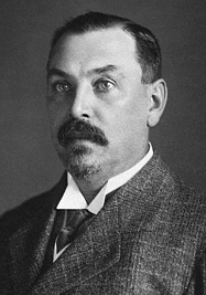
Sir John George Fraser was a prominent Orange Free State lawyer, politician, statesman and member of the Volksraad. He was knighted in 1905.

Burgersdorp is a medium-sized town in Walter Sisulu in the Joe Gqabi District Municipality of the Eastern Cape province of South Africa.
The Johannesburg East Reformed Church was a congregation of the Dutch Reformed Church in South Africa (NGK) in the Johannesburg suburb of Doornfontein, just east of downtown. It is also known as the Irene Church after the sobriquet of its second and third churches on 1 Beit Street. Five weeks before its centennial, on June 1, 1997, Johannesburg East was absorbed by the Johannesburg Reformed Church (NGK), from whence it had seceded on July 8, 1897.

The Langlaagte Reformed Church was the 28th congregation of the Dutch Reformed Church in South Africa (NGK) on the Transvaal and the second in Johannesburg after the Johannesburg Reformed Church (NGK) (1887). The congregation is well known as the spiritual home of the Langlaagte orphanage, later named the Abraham Kriel Children’s Home after Rev. Abraham Kriel, who founded it as pastor of Langlaagte.


