Phumelela Local Municipality

Last updated
Phumelela
Phumelela CoA.png
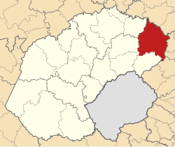
Map of the Free State with Phumelela highlighted.svg
Location in the Free State
Country South Africa
Province Free State
District Thabo Mofutsanyane
Seat Vrede
Wards 8
Government
[1]
  Type Municipal council
  MayorTlokotsi John Motaung
Area
  Total8,183 km2 (3,159 sq mi)
Population
 (2011) [2]
  Total47,772
  Density5.8/km2 (15/sq mi)
Racial makeup (2011)
[2]
   Black African 91.6%
   Coloured 0.4%
   Indian/Asian 0.3%
   White 7.3%
First languages (2011)
[3]
   Zulu 56.0%
   Sotho 32.4%
   Afrikaans 7.5%
   English 1.2%
  Other2.9%
Time zone UTC+2 (SAST)
Municipal codeFS195

Phumelela Municipality (Lua error in Module:Lang at line 1422: attempt to concatenate a nil value.; Lua error in Module:Lang at line 1422: attempt to concatenate a nil value.) is a local municipality within the Thabo Mofutsanyane District Municipality, in the Free State province of South Africa. Phumelela means "to succeed" in isiZulu. [4]

Contents

Main places

The 2001 census divided the municipality into the following main places: [5]

PlaceCodeArea (km2)PopulationMost spoken language
Memel 41601 6.56469 Afrikaans
Thembalihle 41603 2.3315,952 Zulu
Vrede 41604 54.691,482Afrikaans
Warden 41605 11.841,063Afrikaans
Zamani 41606 4.285,008Zulu
Zenzeleni 41607 5.155,720Zulu
Remainder of the municipality 41602 7,463.2121,209Zulu

Politics

The municipal council consists of sixteen members elected by mixed-member proportional representation. Eight councillors are elected by first-past-the-post voting in eight wards, while the remaining eight are chosen from party lists so that the total number of party representatives is proportional to the number of votes received. In the 2021 South African municipal elections the African National Congress (ANC) won a reduced majority of eleven seats on the council.

The following table shows the results of the election. [6]

PartyWardListTotal
seats
Votes%SeatsVotes%Seats
African National Congress 6,76963.2987,00065.10311
Democratic Alliance 1,23511.5501,37812.8222
Economic Freedom Fighters 1,07510.0501,21111.2622
Freedom Front Plus 5675.3006155.7211
Independent candidates 7677.1700
3 other parties2832.6505495.1100
Total10,696100.00810,753100.00816
Valid votes10,69697.0210,75396.73
Invalid/blank votes3282.983643.27
Total votes11,024100.0011,117100.00
Registered voters/turnout24,05045.8424,05046.22

Related Research Articles

<span class="mw-page-title-main">Emalahleni Local Municipality, Mpumalanga</span> Local municipality in Mpumalanga, South Africa

Emalahleni Municipality is a local municipality within the Nkangala District Municipality, in the Mpumalanga province of South Africa. eMalahleni is a Nguni word meaning place of coal.

<span class="mw-page-title-main">Albert Luthuli Local Municipality</span> Local municipality in Mpumalanga, South Africa

Albert Luthuli Municipality is a local municipality within the Gert Sibande District Municipality, in the Mpumalanga province of South Africa. It was named after Albert Luthuli. Carolina is the seat of the municipality.

<span class="mw-page-title-main">Msukaligwa Local Municipality</span> Local municipality in Mpumalanga, South Africa

Msukaligwa Municipality is a local municipality within the Gert Sibande District Municipality, in the Mpumalanga province of South Africa. Ermelo is the seat of the municipality.

<span class="mw-page-title-main">Dipaleseng Local Municipality</span> Local municipality in Mpumalanga, South Africa

Dipaleseng Municipality is a local municipality within the Gert Sibande District Municipality, in the Mpumalanga province of South Africa. Balfour is the seat of the municipality.

<span class="mw-page-title-main">Mkhondo Local Municipality</span> Local municipality in Mpumalanga, South Africa

Mkhondo Municipality is a local municipality within the Gert Sibande District Municipality, in the Mpumalanga province of South Africa. Piet Retief is the seat of the municipality.

<span class="mw-page-title-main">Newcastle Local Municipality</span> Local municipality in KwaZulu-Natal, South Africa

Newcastle Municipality is a local municipality within the Amajuba District Municipality, in the KwaZulu-Natal province of South Africa.

<span class="mw-page-title-main">Maphumulo Local Municipality</span> Local municipality in KwaZulu-Natal, South Africa

Maphumulo Local Municipality is an administrative area in the iLembe District of KwaZulu-Natal in South Africa. Maphumulo is an isiZulu name meaning "place of rest".

uMdoni Local Municipality Area in KwaZulu-Natal, South Africa

uMdoni Municipality is a local municipality within the Ugu District Municipality, in the KwaZulu-Natal province of South Africa. uMdoni is the isiZulu name for the indigenous forest waterberry plant.

<span class="mw-page-title-main">Umzimkhulu Local Municipality</span> Local municipality in KwaZulu-Natal, South Africa

Umzimkhulu Municipality is a local municipality within the Harry Gwala District Municipality, in the KwaZulu-Natal province of South Africa. Umzimkhulu is an isiXhosa and isiZulu word meaning "big/great house". Prior to the Twelfth Amendment of the Constitution of South Africa in 2005, confirmed by the Thirteenth in 2007, it was part of the Eastern Cape.

<span class="mw-page-title-main">Msinga Local Municipality</span> Local municipality in KwaZulu-Natal, South Africa

Msinga Municipality is a local municipality within the Umzinyathi District Municipality, in the KwaZulu-Natal province of South Africa. Msinga is an isiZulu word meaning "a current in the sea where air movement causes ripples on top of the water surface and ends up influencing the nearby climatic conditions through its breeze". The municipality is largely located in deep gorges of the Tugela and Buffalo rivers, isolated from the immediate surrounding municipal areas. The population dynamics result in a growing rural area and a declining urban area in the municipality, contrary to most other areas in the country. This can be attributed to the fact that the urban areas of municipality are very small and are unable to provide the normal range of goods and services provided in urban areas.

<span class="mw-page-title-main">Mpofana Local Municipality</span> Local municipality in KwaZulu-Natal, South Africa

Mpofana Municipality is a local municipality within the Umgungundlovu District Municipality, in the KwaZulu-Natal province of South Africa.

<span class="mw-page-title-main">Jozini Local Municipality</span> Local municipality in KwaZulu-Natal, South Africa

Jozini Municipality is a local municipality within the Umkhanyakude District Municipality, in the KwaZulu-Natal province of South Africa. Significant portions of the municipality have been neglected in terms of economic development. There is a great disparity between the level of service and infrastructure provision between settlement nodes, such as the towns of Mkuze and Jozini, and the surrounding rural areas. Most of the rural area is associated with a lack of development, poverty and poor service provision.

eDumbe Local Municipality Local municipality in KwaZulu-Natal, South Africa

eDumbe Municipality is a local municipality within the Zululand District Municipality, in the KwaZulu-Natal province of South Africa. The municipality is named after the Dumbe mountain.

<span class="mw-page-title-main">Hlabisa Local Municipality</span> Local municipality in KwaZulu-Natal, South Africa

Hlabisa was an administrative area in the Umkhanyakude District of KwaZulu-Natal in South Africa. Hlabisa is an isiZulu surname of the two nkosis (kings) in the area. The municipality was situated within the vicinity of four Tribal Authorities which are the Mkhwanazi Tribal Authority, the Mdletshe Tribal Authority, and two Hlabisa Tribal Authorities.
uMlalazi Local Municipality Local municipality in KwaZulu-Natal, South Africa

uMlalazi Local Municipality is an administrative area in the King Cetshwayo District of KwaZulu-Natal in South Africa. The municipality is named after the uMlalazi River.

<span class="mw-page-title-main">Umzumbe Local Municipality</span> Local municipality in KwaZulu-Natal, South Africa

Umzumbe Municipality is a local municipality within the Ugu District Municipality, in the KwaZulu-Natal province of South Africa. The municipality is named after the Umzumbe River. Towns within the municipal boundaries include Friedenau, KwaDweshula, St Faith’s, and Umzumbe.
<span class="mw-page-title-main">Richmond Local Municipality</span> Local municipality in KwaZulu-Natal, South Africa

Richmond Municipality is a local municipality within the Umgungundlovu District Municipality, in the KwaZulu-Natal province of South Africa.

<span class="mw-page-title-main">Ntambanana Local Municipality</span> Local municipality in KwaZulu-Natal, South Africa

Ntambanana Local Municipality was a local municipality within the uThungulu District of KwaZulu-Natal in South Africa. In 2016, the municipality was dissolved and its territory divided between Mthonjaneni Local Municipality, uMhlathuze Local Municipality and uMfolozi Local Municipality.

<span class="mw-page-title-main">Ndwedwe Local Municipality</span> Local municipality in KwaZulu-Natal, South Africa

Ndwedwe Local Municipality is an administrative area in the iLembe District of KwaZulu-Natal in South Africa.

<span class="mw-page-title-main">Umvoti Local Municipality</span> Local municipality in KwaZulu-Natal, South Africa

Umvoti Municipality is a local municipality within the Umzinyathi District Municipality, in the KwaZulu-Natal province of South Africa.
References

  1. "Contact list: Executive Mayors". Government Communication & Information System. Archived from the original on 14 July 2010. Retrieved 22 February 2012.
  2. 1 2 "Statistics by place". Statistics South Africa. Retrieved 27 September 2015.
  3. "Statistics by place". Statistics South Africa. Retrieved 27 September 2015.
  4. South African Languages - Place names
  5. Lookup Tables - Statistics South Africa
  6. "Election Result Table for LGE2021 — Phumelela". wikitable.frith.dev. Retrieved 2023-10-28.

27°25′48″S29°09′36″E / 27.43000°S 29.16000°E / -27.43000; 29.16000