Pietermaritzburg is the capital and second-largest city in the province of KwaZulu-Natal, South Africa after Durban. It was named in 1838 and is currently governed by the Msunduzi Local Municipality. The town was named in Zulu after King Dingane's royal homestead uMgungundlovu. Pietermaritzburg is popularly called Maritzburg and is often informally abbreviated to PMB. It is a regionally important industrial hub, producing aluminium, timber and dairy products, as well as the main economic hub of uMgungundlovu District Municipality. The public sector is a major employer in the city due to local, district and provincial government offices located here.

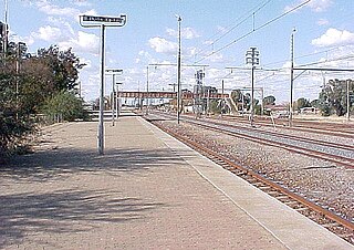
Kroonstad is a town in Free State, South Africa, consisting of the following suburbs: Brentpark, Constantia, Constantia Park, Dawid Malanville, Elandia, Gelukwaarts, Goedgedacht, Heuningspruit, Industria, Jordania, Koekoe Village, Kroonheuwel, Maokeng, Morewag, Noordhoek, Ou Dorp, Panorama, Phomolong, Presidensia, Prison Area, Seisoville, Suidrand, Tuinhof, Uitsig, Vooruitsig, West Park and Wilgenhof. Being the fourth largest town in the Free State, Kroonstad lies approximately two hours' drive along the N1 from Gauteng. It is the second-largest commercial and urban centre in the Northern Free State, and an important railway junction on the main line from Cape Town to Johannesburg.
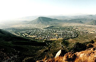
Graaff-Reinet is a town in the Eastern Cape Province of South Africa. It is the oldest town in the province and the fifth oldest town in South Africa, after Cape Town, Stellenbosch, Simon's Town, Paarl and Swellendam. The town was the centre of a short-lived republic in the late 18th century. The town was a starting point for Great Trek groups led by Gerrit Maritz and Piet Retief and furnished large numbers of the Voortrekkers in 1835–1842.

Alberton is a town situated on the southern part of the East Rand of the Gauteng Province in South Africa and is situated very close to the major urban centre of Johannesburg.

Standerton is a large commercial and agricultural town lying on the banks of the Vaal River in Mpumalanga, South Africa, which specialises in cattle, dairy, maize and poultry farming. The town was established in 1876 and named after Boer leader Commandant A. H. Stander. During the First Boer War a British garrison in the town was besieged by the Boers for three months. General Jan Smuts won this seat during elections and went on to assist in setting up the League of Nations. Standerton is the seat of the Lekwa Local Municipality.
Bloemhof is an agricultural town of about 2,000 inhabitants situated on the banks of the Vaal River in North West Province of South Africa.
The following lists events that happened during 1981 in South Africa.

Swellendam is the third oldest town in South Africa, a town with 17,537 inhabitants situated in the Western Cape province. The town has over 50 provincial heritage sites, most of them buildings of Cape Dutch architecture. Swellendam is situated on the N2, approximately 220 km from both Cape Town and George.

Worcester is a town in the Western Cape, South Africa. It is the third-largest city in the Western Cape Province of South Africa. It is located 120 kilometres (75 mi) north-east of Cape Town on the N1 highway north to Johannesburg.

Mitchells Plain is a large census designated sub-place located within the City of Cape Town, Western Cape, South Africa and situated about 28 km (17 mi) from the Cape Town city centre. It is one of South Africa's largest residential areas and contains multiple smaller suburbs. It is located on the Cape Flats on the False Bay coast between Muizenberg and Khayelitsha. Conceived of as a "model suburb" by the apartheid government, it was built during the 1970s to provide housing for Coloured victims of forced removal due to the implementation of the Group Areas Act.

Durbanville, previously called Pampoenkraal, is a town in the Western Cape province of South Africa, part of the greater Cape Town metropolitan area. It is a semi-rural residential suburb on the north-eastern outskirts of the metropolis surrounded by farms producing wine and wheat.

The area known today as Cape Town has no written history before it was first mentioned by Portuguese explorer Bartholomeu Dias in 1488. The German anthropologist Theophilus Hahn recorded that the original name of the area was '||Hui !Gais' – a toponym in the indigenous Khoi language meaning "where clouds gather."

Ceres is the administrative centre and largest town of the Witzenberg Local Municipality in the Western Cape Province of South Africa. Ceres serves as a regional centre for the surrounding towns of Wolseley, Tulbagh, Op-die-Berg and Prince Alfred Hamlet. It is situated in the Warmbokkeveld Valley about 170 km north-east of Cape Town. Ceres is located at the north-eastern entrance to Michell's Pass and was the old route north between Cape Town and Johannesburg, which was later replaced by the N1 highway, which traverses the Breede River Valley to the south.

Springbok is the largest town in the Namaqualand area in the Northern Cape province of South Africa. It was called Springbokfontein until 1911, when it was shortened to Springbok. Springbok is located on the N7 national route which connects the Cape with Namibia, and at the western end of the N14, which connects it with Upington and Pretoria. It is the main town of the Nama Khoi Local Municipality, which also includes a number of surrounding towns such as Okiep and Nababeep.

Gardens is an affluent inner-city suburb of Cape Town located just to the south of the city centre located in the higher elevations of the "City Bowl" and directly beneath Table Mountain and Lion's Head. It is home to several national museums such as Iziko South African National Gallery and the Iziko South African Museum. The University of Cape Town also houses its Fine Arts department in the suburb, at Michaelis School of Fine Art. Company's Garden, South Africa's oldest garden, a public park and heritage site is a focal point of the suburb. The area is also home to the oldest synagogue in Southern Africa, the Old Shul and its successor, the Gardens Shul, "The Mother Synagogue of South Africa."

Many people of European heritage in South Africa are descended from Huguenots. Most of these originally settled in the Dutch Cape Colony, but were absorbed into the Afrikaner and Afrikaans-speaking population, because they had religious similarities to the Dutch colonists.

Colesberg is a town with 17,354 inhabitants in the Northern Cape province of South Africa, located on the main N1 road from Cape Town to Johannesburg.
Mosebenzi Joseph Zwane was the Minister of Mineral Resources of South Africa in the Second Cabinet of former President Jacob Zuma serving from 2015 until 2018. A controversial figure, Zwane resigned on 25 February 2018 following allegations of state capture and in particular his role in the Vrede Dairy Project, which helped bankroll the Gupta Family wedding.
The Vrede Dairy Project is a South African dairy project established in 2012 on Krynaauwslust Farm, near the town of Vrede, Free State Province. The dairy was established as a public-private partnership with Estina, a Black Economic Empowerment company, as part of the Free State provincial government's agricultural project, Mohoma-Mobung. Estina was given the land under a free 99 year lease.
Motlagomang Grazy "Mamiki" Qabathe is a South African politician from the Free State. She represented the African National Congress (ANC) in the Free State Provincial Legislature between January 2008 and May 2024. During that time she served in the Executive Council of the Free State continuously between 2008 and 2023, excepting a term as Speaker of the Free State Provincial Legislature from 2015 to 2019.


