
The Orange Free State was an independent Boer sovereign republic under British suzerainty in Southern Africa during the second half of the 19th century, which ceased to exist after it was defeated and surrendered to the British Empire at the end of the Second Boer War in 1902. It is one of the three historical precursors to the present-day Free State province.
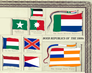
The Boer republics were independent, self-governing republics formed by Dutch-speaking inhabitants of the Cape Colony and their descendants. The founders – variously named Trekboers, Boers and Voortrekkers – settled mainly in the middle, northern, north-eastern and eastern parts of present-day South Africa. Two of the Boer republics achieved international recognition and complete independence: the South African Republic and the Orange Free State. The republics did not provide for the separation of church and state, initially allowing only the Dutch Reformed Church, and later also other Protestant churches in the Calvinist tradition. The republics came to an end after the Second Boer War of 1899–1902, which resulted in British annexation and later incorporation of their lands into the Union of South Africa.
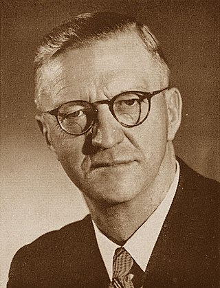
Charles Robberts Swart, nicknamed "Blackie", was a South African politician who served as the last governor-general of the Union of South Africa from 1959 to 1961 and the first state president of the Republic of South Africa from 1961 to 1967.
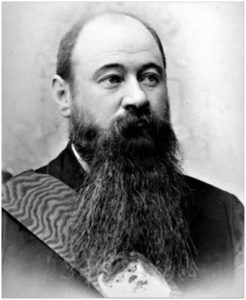
MartinusTheunis Steyn was a South African lawyer, politician, and statesman. He was the sixth and last president of the independent Orange Free State from 1896 to 1902.

The N1 is a national route in South Africa that runs from Cape Town through Bloemfontein, Johannesburg, Pretoria and Polokwane to Beit Bridge on the border with Zimbabwe. It forms the first section of the famed Cape to Cairo Road.

Kestell is a small maize farming town in the Free State province of South Africa.

Senekal is a town situated on the banks of the Sand River in the eastern part of the Free State province of South Africa. It was named after Commandant FP Senekal. It is the second largest town in Setsoto Municipality after Ficksburg, the largest town and capital of Setsoto. Senekal lies on the N5 national road between Winburg on the west and Bethlehem to the east. It has two townships, Matwabeng and OR Tambo Section, the latter being the latest, largest and fastest growing.

Winburg is a small mixed farming town in the Free State province of South Africa.

Smithfield is a small town in the Free State province of South Africa. Founded in 1848 in the Orange River Sovereignty, the town is situated in a rural farming district and is the third oldest town in present-day Free State, after Philippolis and Winburg.

The Province of the Orange Free State, commonly referred to as the Orange Free State, Free State or by its abbreviation OFS, was one of the four provinces of South Africa from 1910 to 1994. After 27 April 1994 it was dissolved following the first non-racial election in South Africa. It is now called the Free State Province.
The N5 is a national route in South Africa that connects the N1 at Winburg with the N3 at Harrismith, via Senekal, Paul Roux and Bethlehem.
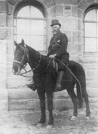
Christoffel Cornelis Froneman, commonly known as Stoffel Froneman, was veldkornet, general and Vice-Commander-in-Chief of the Orange Free State Boer forces during the Anglo-Boer War of 1899-1902.
The R703 is a regional route in the Free State, South Africa.
The R708 is a Regional Route in South Africa that connects Jan Kempdorp in the Northern Cape with Clocolan in the Free State via Christiana, Hertzogville, Bultfontein, Theunissen, Winburg and Marquard.
The R709 is a Regional Route in Free State, South Africa that connects Winburg with Hobhouse via Excelsior and Tweespruit.
Mosupatsela FM Stereo is a South African community radio station based in c section in Botshabelo, Free State.
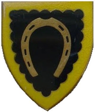
Harrismith Commando was a light infantry regiment of the South African Army. It formed part of the South African Army Infantry Formation as well as the South African Territorial Reserve.

Winburg Commando was a light infantry regiment of the South African Army. It formed part of the South African Army Infantry Formation as well as the South African Territorial Reserve.

The Eerste Pastorie is an historic residence in Winburg in the Free State of South Africa. The building was constructed in 1850 for the Dutch Reformed Church's pastor or predikant.


