Tswelopele Local Municipality

Last updated
Tswelopele
Tswelopele CoA.png
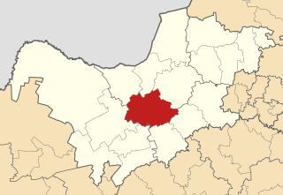
Map of the Free State with Tswelopele highlighted.svg
Location in the Free State
Coordinates: 28°17′27″S26°09′00″E / 28.29083°S 26.15000°E / -28.29083; 26.15000
Country South Africa
Province Free State
District Lejweleputswa
Seat Bultfontein
Wards 8
Government
[1]
  Type Municipal council
  MayorRosy Phukuntse
Area
  Total6,524 km2 (2,519 sq mi)
Population
 (2011) [2]
  Total47,625
  Density7.3/km2 (19/sq mi)
Racial makeup (2011)
[2]
   Black African 91.2%
   Coloured 1.2%
   Indian/Asian 0.4%
   White 6.9%
First languages (2011)
[3]
   Sotho 54.0%
   Xhosa 19.9%
   Tswana 12.0%
   Afrikaans 8.3%
  Other5.8%
Time zone UTC+2 (SAST)
Municipal codeFS183

Tswelopele Municipality (Sotho : Masepala wa Tswelopele; Xhosa : uMasipala wase Tswelopele; Tswana : Mmasepala wa Tswelopele) is a local municipality within the Lejweleputswa District Municipality, in the Free State province of South Africa. Tswelopele is a Sesotho word meaning "progress". [4]

Contents

Main places

The 2001 census divided the municipality into the following main places: [5]

PlaceCodeArea (km2)PopulationMost spoken language
Bultfontein 40901 42.751,034 Afrikaans
Hoopstad 40902 28.34662Afrikaans
Phahameng 40903 3.3720,063 Sotho
Tikwana 40904 1.7311,032Sotho
Remainder of the municipality 40905 6,447.2020,913Sotho

Politics

The municipal council consists of fifteen members elected by mixed-member proportional representation. Eight councillors are elected by first-past-the-post voting in eight wards, while the remaining seven are chosen from party lists so that the total number of party representatives is proportional to the number of votes received.

In the 2021 South African municipal elections the African National Congress (ANC) won a reduced majority of ten seats on the council.

The following table shows the results of the 2021 election. [6]

PartyWardListTotal
seats
Votes%SeatsVotes%Seats
African National Congress 7,11661.4197,17461.80110
Democratic Alliance 1,82915.7801,81015.5933
Economic Freedom Fighters 1,32211.4101,34411.5822
Tikwana Youth Power 6695.7706685.7511
Freedom Front Plus 4103.5404033.4711
Independent candidates 670.5800
3 other parties1751.5102101.8100
Total11,588100.00911,609100.00817
Valid votes11,58897.2711,60997.34
Invalid/blank votes3252.733172.66
Total votes11,913100.0011,926100.00
Registered voters/turnout25,85646.0725,85646.12

Related Research Articles

<span class="mw-page-title-main">Tswaing Local Municipality</span> Local municipality in North West, South Africa

Tswaing Municipality is a local municipality within the Ngaka Modiri Molema District Municipality, in the North West province of South Africa. It consists of the towns of Delareyville, Sannieshof and Ottosdal.

<span class="mw-page-title-main">Rustenburg Local Municipality</span> Local municipality in North West, South Africa

Rustenburg Municipality is a local municipality within the Bojanala Platinum District Municipality, in the North West province of South Africa. Rustenburg is situated at the foot of the Magalies mountain range. Rustenburg was proclaimed a township in 1851. The city of Rustenburg is situated some 112 km northwest from both Johannesburg and Pretoria. It is a malaria-free area. Rustenburg is the fastest growing municipality in South Africa, with the population rising from 387,096 in 2001 to 449,776 in 2007. It is the most populous municipality in the North West province.

<span class="mw-page-title-main">Emalahleni Local Municipality, Mpumalanga</span> Local municipality in Mpumalanga, South Africa

Emalahleni Municipality is a local municipality within the Nkangala District Municipality, in the Mpumalanga province of South Africa. eMalahleni is a Nguni word meaning place of coal.

<span class="mw-page-title-main">Mogale City Local Municipality</span> Local municipality in Gauteng, South Africa

Mogale City Local Municipality is a local municipality within the West Rand District Municipality, in the Gauteng province of South Africa.
<span class="mw-page-title-main">Thulamela Local Municipality</span> Local municipality in Limpopo, South Africa

Thulamela Municipality is a local municipality within the Vhembe District Municipality, in the Limpopo province of South Africa. Its municipal boundaries were greatly altered after the 2016 municipal elections when much of the area that formerly belonged to the municipality, including the town of Malamulele, was incorporated into the newly formed Collins Chabane Local Municipality. It is named after the Thulamela ruins located near the Pafuri Gate of the Kruger National Park.

<span class="mw-page-title-main">Dipaleseng Local Municipality</span> Local municipality in Mpumalanga, South Africa

Dipaleseng Municipality is a local municipality within the Gert Sibande District Municipality, in the Mpumalanga province of South Africa. Balfour is the seat of the municipality.
<span class="mw-page-title-main">Bela-Bela Local Municipality</span> Local municipality in Limpopo, South Africa

Bela-Bela Municipality is a local municipality within the Waterberg District Municipality, in the Limpopo province of South Africa. The seat is Bela-Bela. The municipality lies north of Hammanskraal. It is the only municipality in South Africa that straddles 4 provinces.
<span class="mw-page-title-main">Makhado Local Municipality</span> Local municipality in Limpopo, South Africa

Makhado Municipality is a local municipality within the Vhembe District Municipality, in the Limpopo province of South Africa. The seat is Louis Trichardt.

<span class="mw-page-title-main">Kgetlengrivier Local Municipality</span> Local municipality in North West, South Africa

Kgetlengrivier Municipality is a local municipality within the Bojanala Platinum District Municipality, in the North West province of South Africa.

<span class="mw-page-title-main">Greater Taung Local Municipality</span> Local municipality in North West, South Africa

Greater Taung Municipality is a local municipality within the Dr Ruth Segomotsi Mompati District Municipality, in the North West province of South Africa. The seat of the municipality is Taung.
<span class="mw-page-title-main">Kgatelopele Local Municipality</span> Local municipality in Northern Cape, South Africa

Kgatelopele Municipality is a local municipality within the ZF Mgcawu District Municipality, in the Northern Cape province of South Africa. Kgatelopele is a Setswana name meaning "progress".

<span class="mw-page-title-main">Kopanong Local Municipality</span> Local municipality in Free State, South Africa

Kopanong Municipality is a local municipality within the Xhariep District Municipality, in the Free State province of South Africa. Kopanong is a Sesotho word meaning "meeting place or where people are invited". The name earmarks unity and seeks to encourage co-operation.

<span class="mw-page-title-main">Tokologo Local Municipality</span> Local municipality in Free State, South Africa

Tokologo Municipality is a local municipality within the Lejweleputswa District Municipality, in the Free State province of South Africa. Tokologo is a Setswana word meaning "freedom".

<span class="mw-page-title-main">Elundini Local Municipality</span> Local municipality in Eastern Cape, South Africa

Elundini Municipality is a local municipality within the Joe Gqabi District Municipality, in the Eastern Cape province of South Africa. The name originates from isiZulu and refers to the Drakensberg Mountains.

<span class="mw-page-title-main">Phumelela Local Municipality</span> Local municipality in Free State, South Africa

Phumelela Municipality is a local municipality within the Thabo Mofutsanyane District Municipality, in the Free State province of South Africa. Phumelela means "to succeed" in isiZulu.

<span class="mw-page-title-main">Letsemeng Local Municipality</span> Local municipality in Free State, South Africa

Letsemeng Municipality is a local municipality within the Xhariep District Municipality, in the Free State province of South Africa.

<span class="mw-page-title-main">Dikgatlong Local Municipality</span> Local municipality in Northern Cape, South Africa

Dikgatlong Municipality is a local municipality within the Frances Baard District Municipality, in the Northern Cape province in South Africa. Dikgatlong is a Setswana name meaning "confluence", and refers to the place where the Harts and Vaal rivers flow into each other in Delportshoop. The name was used as early as 1700.
<span class="mw-page-title-main">Senqu Local Municipality</span> Local municipality in Eastern Cape, South Africa

Senqu Municipality is a local municipality within the Joe Gqabi District Municipality, in the Eastern Cape province of South Africa. Senqu is the Sesotho name for the Orange River.

<span class="mw-page-title-main">Masilonyana Local Municipality</span> Local municipality in Free State, South Africa

Masilonyana Municipality is a local municipality within the Lejweleputswa District Municipality, in the Free State province of South Africa. Masilonyana is a Setswana word meaning "freedom".

<span class="mw-page-title-main">Mohokare Local Municipality</span> Local municipality in Free State, South Africa

Mohokare Municipality is a local municipality within the Xhariep District Municipality, in the Free State province of South Africa. Mohokare is the Sesotho word for the Caledon River, which runs through the municipality.

References

  1. "Contact list: Executive Mayors". Government Communication & Information System. Archived from the original on 14 July 2010. Retrieved 22 February 2012.
  2. 1 2 "Statistics by place". Statistics South Africa. Retrieved 27 September 2015.
  3. "Statistics by place". Statistics South Africa. Retrieved 27 September 2015.
  4. South African Languages - Place names
  5. Lookup Tables - Statistics South Africa
  6. "Election Result Table for LGE2021 — Tswelopele". wikitable.frith.dev. Retrieved 2023-10-28.