
Elkhart Lake is a village in Sheboygan County, Wisconsin, United States, located within the northwestern part of the county within the Town of Rhine. The population was 967 at the 2010 census. It is included in the Sheboygan, Wisconsin Metropolitan Statistical Area. Elkhart Lake may be best known for hosting road races on public county roads during the 1950s, later moving to a dedicated race track called Road America, which is located a few miles south of the village.

The Ice Age Trail is a National Scenic Trail stretching 1,200 miles (1,900 km) in the state of Wisconsin in the United States. The trail is administered by the National Park Service, and is constructed and maintained by private and public agencies including the Ice Age Trail Alliance, a non-profit and member-volunteer based organization with local chapters. It became an official unit of the National Park System in 2023.

The Cascades Lakes Scenic Byway is a National Scenic Byway in central Oregon in the United States. It runs for 66 miles (106 km) in the rugged country of Deschutes and Klamath counties on the east side of the Cascade Range. It offers particularly good views of Mount Bachelor, Broken Top, and the Three Sisters (Oregon) mountains and provides access to many recreational facilities in central Oregon. The route is so named because it weaves past a number of small natural lakes along the Cascades as well as several reservoirs on the upper Deschutes River.
Kettle Moraine is a large moraine in the state of Wisconsin, United States. It stretches from Walworth County in the south to Kewaunee County in the north. It has also been referred to as the Kettle Range and, in geological texts, as the Kettle Interlobate Moraine.

The Kettle Moraine State Forest is a state forest in southeastern Wisconsin. The chief feature of the reserve is the Kettle Moraine, a highly glaciated area. The area contains very hilly terrain and glacial landforms, such as kettles, kames and eskers. The 56,000-acre (23,000 ha) forest is divided into two large and three small units, which are spread across a hundred miles.

State Trunk Highway 67 is a Wisconsin state highway running from the Wisconsin–Illinois state line east of Beloit north to U.S. Highway 151 (US 151) east of Chilton. With the inclusion of the new Oconomowoc bypass, WIS 67 is approximately 160 miles (260 km) in length.
The Pike Lake Unit of the Kettle Moraine State Forest is a 825-acre (334 ha) unit of the Wisconsin state park system. The unit is located just east of Hartford, Wisconsin on State Highway 60, on the east shore of the 446-acre (180 ha) Pike Lake. It was dedicated by Wisconsin governor Patrick J. Lucey in June 1971.

State Trunk Highway 17 is a state highway in the U.S. state of Wisconsin. The highway is a secondary route in northeastern Wisconsin that directly connects Rhinelander, Eagle River and the central and eastern parts of Michigan's Upper Peninsula with Wausau, Wisconsin and points south and west.

State Trunk Highway 23 is a state highway in the U.S. state of Wisconsin. The route is signed as a north–south route from Shullsburg to Wisconsin Dells and as an east–west route from Wisconsin Dells to Sheboygan. With the exception of freeway segments between Sheboygan Falls and Sheboygan, an expressway segment between Sheboygan Falls past Greenbush to Fond du Lac, a freeway concurrency with Interstate 39 (I-39), and an expressway segment concurrent with U.S. Highway 151 (US 151), the highway is generally either two-lane surface road or urban multilane arterial. WIS 23 provides access to several important Wisconsin destinations, such as the House on the Rock, the Wisconsin Dells area and various state parks.

State Trunk Highway 42 is a state highway in the U.S. state of Wisconsin. It runs for 135 miles (217 km) north–south in northeast Wisconsin from Sheboygan to the ferry dock in Northport. Much of the highway is part of the Lake Michigan Circle Tour from the eastern junction with U.S. Highway 10 (US 10) in Manitowoc to its junction with WIS 57 in Sister Bay. WIS 42 parallels I-43 from Sheboygan to Manitowoc, and parallels WIS 57 throughout much of the route, particularly from Manitowoc to Sturgeon Bay, meeting the northern terminus of WIS 57 in Sister Bay.

Wisconsin Highway 57 is a 191.82-mile-long (308.70 km) state highway in Wisconsin, United States. It runs from its southern terminus at WIS 59 in Milwaukee to its northern terminus at WIS 42 in Sister Bay. Much of WIS 57 parallels Interstate 43 (I-43) and WIS 42, particularly from Saukville to its northern terminus in Sister Bay. The highway runs concurrently with I-43 for 12 miles (19 km) in Ozaukee County. Like most Wisconsin state highways, WIS 57 is maintained by the Wisconsin Department of Transportation (WisDOT).

Dundee is an unincorporated community located in the town of Osceola, in Fond du Lac County, Wisconsin, United States. It is located on Wisconsin Highway 67 in the Kettle Moraine State Forest. The Kettle Moraine Scenic Drive runs through the community.

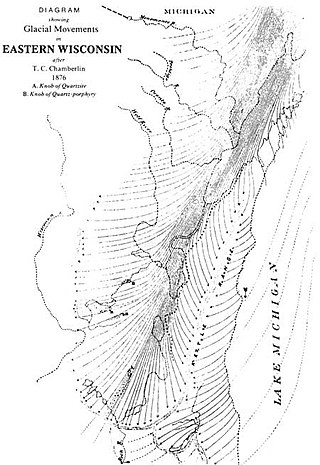
Wisconsin, a state in the Midwestern United States, has a vast and diverse geography famous for its landforms created by glaciers during the Wisconsin glaciation 17,000 years ago. The state can be generally divided into five geographic regions—Lake Superior Lowland, Northern Highland, Central Plain, Eastern Ridges & Lowlands, and Western Upland. The southwestern part of the state, which was not covered by glaciers during the most recent ice age, is known as the Driftless Area. The Wisconsin glaciation formed the Wisconsin Dells, Devil's Lake, and the Baraboo Range. A number of areas are protected in the state, including Devil's Lake State Park, the Apostle Islands National Lakeshore, and the Chequamegon–Nicolet National Forest.

The Loew Lake Unit of the Kettle Moraine State Forest is a 1,090-acre (4 km2) member of the Wisconsin state park system. The unit offers hiking, hunting, and horse riding along the east branch of the Oconomowoc River and the shore of 23-acre (0 km2) Loew Lake, and also features a number of large conifer plantations. A section of the Ice Age National Scenic Trail runs through the park as it follows the Kettle Moraine.
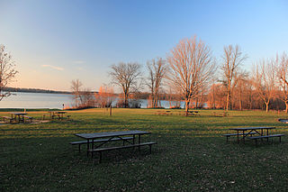
Whitewater Lake is located in Walworth County, Wisconsin, United States in the Kettle Moraine State Forest.

Chinatown is an unincorporated community in the town of Osceola, Fond du Lac County, Wisconsin, United States. Chinatown is located on the northeast shore of Long Lake near the Sheboygan County line. Despite its name, there is no Chinatown in this area.

The Wisconsin State Trunk Highway System is the state highway system of the U.S. state of Wisconsin, including Wisconsin's segments of the Interstate Highway System and the United States Numbered Highway System, in addition to its other state trunk highways. These separate types of highways are respectively designated with an I-, US, or STH- prefix. The system also includes minor roads designated as Scenic Byways, four routes intended to promote tourism to scenic and historic areas of the state; and as Rustic Roads, lightly traveled and often unpaved local roads which the state has deemed worthy of preservation and protection. The state highway system, altogether totaling 11,753 miles (18,915 km) across all of Wisconsin's 72 counties, is maintained by the Wisconsin Department of Transportation (WisDOT).
The Eisenbahn State Trail is a multi-purpose trail designated as a park by the Wisconsin Department of Natural Resources. The trail is maintained by the counties through which it transgresses, Washington and Fond du Lac counties. The trail extends 25 miles, from the village of Eden in the north to Rusco Road, south of West Bend. The trail follows the route of the former Fox Valley Railroad.

The Southern Unit of the Kettle Moraine State Forest includes more than 22,000 acres of land throughout southern Wisconsin and spans several state parks and natural areas. The area also features varied environments from restored prairie, forests, and lakes, along with providing a multitude of recreational opportunities such as hiking, birdwatching, fishing, camping, and hunting. The Kettle Moraine Scenic Drive also extends within this region as well as through a larger portion of the state.

The 59th Assembly District of Wisconsin is one of 99 districts in the Wisconsin State Assembly. Located in eastern Wisconsin, the district comprises parts of northern Washington County, northern Ozaukee County, southern Sheboygan County, northeast Dodge County, and southeast Fond du Lac County. It includes the villages of Adell, Belgium, Campbellsport, Cedar Grove, Eden, Fredonia, Kewaskum, Random Lake, Saukville, and Theresa, along with part of the city of West Bend. It also contains the University of Wisconsin–Milwaukee at Washington County campus, the West Bend campus of Moraine Park Technical College, Kettle Moraine State Forest Northern Unit, Cedarburg Bog, Harrington Beach State Park, and most of the Theresa Marsh. The district is represented by Republican Ty Bodden, since January 2023.


