Bheri Zone was one of the fourteen zones located in the Mid-Western Development Region of Nepal. Nepalgunj were the administrative headquarters.

Banke District (Nepali: बाँके जिल्ला [bãke], a part of Lumbini Province, is one of the 77 districts of Nepal. The district, located in midwestern Nepal with Nepalganj as its district headquarters, covers an area of 2,337 km2 and had a population of 385,840 in 2001 and 491,313 in 2011. There are three main cities in the Banke District: Nepalganj, Kohalpur and Khajura Bajaar.
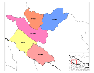
Dailekh District a part of Karnali Pradesh, is one of the 77 districts of Nepal. The district, with Dailekh as its district headquarters, covers an area of 1,502 km2 (580 sq mi) and had a population of 225,201 in 2001 and 261,770 in 2011.
Surkhet District is the province capital of Karnali province.Surkhet is the one of the ten districts of Karnali located about 600 kilometres (373 mi) west of the national capital Kathmandu. The district's area is 2,488.64 square kilometres (960.87 sq mi)which is longest in Nepal. It had 288,527 population in 2001 and 350,804 in 2011 which male comprised 169,461 and female 181,381. It is the district headquarters of surkhet and commercial hub of the Karnali state of the new federal republic.

Nepalgunj, also spelled Nepalganj, is a Sub-Metropolitan City in Banke District, Nepal. It lies on the Terai plains near the southern border with Bahraich district in Uttar Pradesh, India. Nepalgunj is 153 kilometers south-west of Ghorahi and 16 km south of Kohalpur. Former Village Development Committee: Udayapur, Bhawaniyapur, Piprahawa, Jaispur, Paraspur, Indrapur, Khaskarkado, Bashudevpur, Manikapur and Puraina were added to territory in order to make it Sub metropolitan city on 2071 Paush 28 and later Puraini was also added in list on 2072 Paush 21. Further, while restructuring of local levels nationwide, ward no. 23 was taken out to Janaki Rural Municipality and ward no. 7 of Hirminiya VDC was added to Nepalgunj.
Kohalpur is a municipality in Banke District of Lumbini province of Nepal. The municipality was established on 18 May 2014 merging the existing two Village Development Committees i.e. Rajhena and Kohalpur. The town is in East-West highway and one of the fastest developing places in Nepal. A neighboring city Nepalgunj is on South (16 km), with Ghorahi city (135 km) to west in Dang District and further 6 km is the Indian border. In fact it is a growing city in the western region of Nepal. It has a junction to diverse the roadway transport to east, west, north and south from the city.

Ghorahi is the seventh largest city and largest sub-metropolitan city of Nepal. The city lies in Lumbini Province in the mid-Western part of Nepal. It is the largest city of Dang Deukhuri District of southwest Nepal. Located in the Inner Terai region, it lies 413 kilometres (257 mi) south-west of Nepal's capital Kathmandu and is one of the Counter Magnets being developed as an alternative centre of growth to help ease the migration and population explosion in the Kathmandu metropolitan area. It is the largest city of the Rapti Zone and is surrounded by the Sivalik Hills to the south and Mahabharata Range to the north.
The Nepalese Children's Education Fund (NCEF) is a non-profit organization that has been working to develop the potential of disadvantaged Nepalese children through education.
Indrapur is a town in Banke District in Province No. 5 of south-western Nepal. At the time of the 1991 Nepal census it had a population of 5,403 and had 1056 houses in the town. It had been a part of Nepalgunj sub-metropolitan city while expansion of municipality in to sub metropolitan city. However, this part of Sub-metropolitan city was structured under Janaki Rural Municipality.
Jaispur is a town in Banke District in the Bheri Zone of south-western Nepal. At the time of the 1991 Nepal census it had a population of 4,214 and had 683 houses in the town. Now, it is a part of Nepalgunj sub-metropolitan city.
Khajura Khurda is a town in Banke District in the Bheri Zone of south-western Nepal. At the time of the 1991 Nepal census it had a population of 4,508 and had 831 houses in the town.

The Mid-Western Development Region was one of the largest and formerly one of Nepal's five development regions. Westward from the Central region surrounding Kathmandu were the Western, Mid-Western and finally Far-Western regions. Counter-intuitively, Mid-Western lay west of Western.
Lalbandi is a Municipality in Sarlahi District in the Janakpur Zone of south-eastern Nepal. The municipality was established on 18 May 2014 by merging the existing Parwanipur VDC, Netragung vdc, Jabdi, Lalbandi and Pattharkot VDCs. At the time of the 2011 Nepal Census it had a population of 59,395 people living in 3295 individual households. There are 17 wards in this municipality. It is the largest municipality in Sarlahi district. The office of this municipality is in ward no.6 Located in the Lalbandi. Lalbandi Bazar, located on the East West Mahendra highway, is one of the main trading areas within the municipal area. Bordering East Ishwarpur Municipality, West Hariwan and Haripur Municipality, North Sindhuli District and bordering Haripur and Ishwarpur in the south, Lalbandi Bazar is the main trading site of the district.

Musikot is a municipality and the district headquarter of Western Rukum District in Karnali province of Nepal that was established as Musikot Khalanga on 2 December 2014 by merging the two former Village development committees Musikot and Khalanga. It lies on the bank of Sani Bheri River. It borders with Eastern Rukum in the east, Sanibheri rural municipality in the west, Banfikot rural municipality in the north and Tribeni rural municipality and Rolpa district in the south. Musikot was formerly called Musikot Khalanga and served as the district headquarter of Rukum District.
The Dundwa Range is a subrange of the Sivalik Hills in western Nepal and northern Uttar Pradesh, India. It separates the Outer Terai of Balarampur and Shravasti districts in Uttar Pradesh from Deukhuri Valley in Nepal's Dang-Deukhuri and eastern Banke districts. The international border follows the southern edge of this range, leaving a zone of forested Bhabar inside Uttar Pradesh.
Garuda is a Municipality in Rautahat District in the Narayani Zone of south-eastern Nepal. It is a newly created municipality by merging 7 former Village development committees namely Garuda Bairiya, Malahi, Basbiti Jingadiya, Gedahiguthi, Jayanagar, Mahamadpur and Pothiyahi [1].

Lumbini Province is one of the seven provinces established by the new constitution of Nepal which was adopted on 20 September 2015. The province is Nepal's fourth most populous province and third largest province by area. Lumbini is bordered Gandaki Province and Karnali Province to the north, Sudurpashchim Province to the west, and Uttar Pradesh of India to the south. Lumbini is one of the two Nepalese provinces to have an international border only with India. Lumbini's capital, Deukhuri, is near the geographic centre of the province; it's a small town which is currently being developed to meet the prerequisite of provincial capital. The major cities in this province are Butwal and Siddharthanagar in Rupandehi District, Nepalgunj in Banke District, Tansen in Palpa District, and Ghorahi and Tulsipur in Dang District.
Gadhimai is a municipality in Rautahat district of Narayani zone, Nepal. It lies at the border of Rautahat district that links Sarlahi District over Bagmati River. It was formed by merging former 6 Village development committees Gamhariya, samanpur, Sangrampur, Bahuwa Madanpur, Dharampur and Bariyarpur just before 2017 Nepalese local elections.

Ratna Highway is a highway in western Nepal that crosses the districts of Banke and Surkhet in a south to north direction. The 113.08 km highway starts at Nepalgunj, where it depicts a continuation of National Highway 927 of India and runs towards the North, where it crosses Mahendra Highway at Kohalpur. The highway continues north and leave the Terai Plains, crosses Babai River and terminates in Birendranagar, from where Karnali Highway continues northwards.

