Khodad

Last updated

Khodad
Town
GMRT antenna at sunset.jpg
Giant Metrewave Radio Telescope (GMRT) near Narayangaon
India Maharashtra location map.svg
Red pog.svg
Khodad
Location in Maharashtra, India
Coordinates: 19°07′00″N73°55′00″E / 19.11667°N 73.91667°E / 19.11667; 73.91667 Coordinates: 19°07′00″N73°55′00″E / 19.11667°N 73.91667°E / 19.11667; 73.91667
CountryFlag of India.svg  India
State Maharashtra
District Pune
Taluka Junnar
Elevation
656 m (2,152 ft)
Languages
  Official Marathi
Time zone UTC+5:30 (IST)
PIN
410504
Telephone code91-2132-XXXXXX
Vehicle registration MH-14

Khodad is a town in the Pune district of Maharashtra state, India. Khodad Village is situated in Junner taluka of Pune district of Maharashtra state, India. It is famous for Giant Metrewave Radio Telescope (GMRT), the largest telescope at metre wavelengths in the world, which attracts radio astronomers from different countries. [1] Khodad is located on Junner & Ambegao taluka border. Khodad is surrounded by Junnar Taluka towards west, Khed Taluka towards South, Parner & Ambegaon Taluka towards East, Shirur Taluka towards North.

Contents

Location

Village is at 9 Kilometer from Narayangaon, which is one of the most important town in Pune District. Location of Khodad is on East of Narayangao towards Ambegao taluka. Situated at 87 km from pune on Pune Nashik highway. this region belongs to Desh or Paschim Maharashtra region. It fallows under Pune Division. It is at 26 km from Junnar, taluka headquarters. 5 170 km from Mumbai State capital of Maharashtra.4 Jadhavwadi (3 km), Thorandale (5 km), Ranjani (5 km), Walati (6 km), Bhorwadi (2 km), Nagapur (7 km) are the nearby villages to Khodad. Manchar, Junnar, Shirur, Talegaon Dabhade are the nearby Cities to Khodad. Village is situated at bank of Meena River. There is pyramid Shape Mountain at East of Khodad towards Parner taluka end. Local people call it as Khodad che Pathar (plateau of Khodad) Manjarwadi is located at 5 km West from Khodad. On South on the opposite side of Meena River there is hermitage of Mahanubhav panth. Narayangad is located at 5 kilometer North of Khodad. It is believed that Narayangao got its name from this fort. The fort is from the Satvahan dynasty and was used as a watch point for the Junnar Paithan route. According to Census 2011 information the location code or village code of Khodad village is 555388. Khodad village is located in Junnar Tehsil of Pune district in Maharashtra, India. It is situated 26km away from sub-district headquarter Junnar and 75km away from district headquarter Pune. As per 2009 stats, Khodad village is also a gram panchayat.

The total geographical area of village is 2855 hectares. Khodad has a total population of 4,188 peoples. There are about 920 houses in Khodad village. Junnar is nearest town to Khodad which is approximately 26km away.

Inhabitants

The population of Khodad is around 4500 to 5000. Marathi is the main language of majority of the people. Hindi & Urdu is also used by minority people. Khodad is divided roughly on the basis of people living in that particular vicinity. Main Village, Mule mala, Gakiwad mala, Ghangale Mala, Kharmale Mala, Erande mala near Datta temple in Erande mala 5-6 boys in the army, are some of the main parts (mala in local language) of Village base upon the Surname of people live in that area. The majority of the population is Hindu but there are quite considerable numbers of Muslim Families in Khodad engage in their Family business like Kasar, Mutton Shop or Small shop in Village market area.

There are few temples in Village. Goddess Mukktai is gramadaivata of Khodad any every year Ram Navami the main yatra of the village welcome to everybody during the yatra. There is small Darga exactly opposite of Temple. Which is considered as sigh of brotherhood among Hindu Muslim population of village. There are two Hanuman Temples each at South & North extreme of Village boundaries. Also there are two more Temples of Vithoba Rakumai & Shiva right on the bank of Meena river. New Temple of God Ram near vipul pokharkar house.

Occupation

Agriculture is main occupation of population. Some members from Farmer family got the job in GMRT as compensation of land acquired by government for GMRT project. Those families who had lost their land under GMRT project in 1984 had been awarded with one job post at GMRT as 2ndry level employees. Most of the young generation had shifted to Mumbai or other big cities in Maharashtra for Jobs & business. There are some family business in Khodad which include Carpenter, Gavandi, Kasar, Vani etc.

Agriculture

There are two seasons of cropping Kharif & Rabi. Wheat, Groundnut, Sugarcane, Potato, Onions, Bajari are some of the main crops in khodad. But farmers in village are taking up the new way farming to yield non traditional crops like Tomato, Cabbage and making it success story.

Weather

Khodad observe three main climate seasons Summer, Winter and Monsoon. Highest temperature is mostly recorded in month of April. Pre monsoon rain arrives in last week of May. Monsoon rains hit the village at start of June. It have average rain fall around 700 mm. Heavy rain affect the daily routines of villagers very frequently. Season of winter starts in November and it continue until February. Sharp fall in temperature is indicator of arrival of winter. Day temperature varies between 25 and 10 Celsius. Nights are more cooler as compared to day time. Some time temperature falls till 4 to 5 Celsius.

Tourism

View of Malshej Hills Malshej Hills.jpg
View of Malshej Hills

Junnar taluka is noted for the presence of 27 leopards in a 500sq m area. Leopard Rehabilitation Center in Manikdoh, around 25 km west to the Narayangaon is becoming major tourist attraction ever since its establishment. Malshej Ghat a famous tourist destination in the western ghats is at a 45 minutes drive away.

GMRT

GMRT is operated by the National Centre for Radio Astrophysics, a part of the Tata Institute of Fundamental Research, Mumbai. At the time it was built, it was world's largest interferometric array. And that was the time when first Khodad came on world map.

The Site of Giant Metrewave Radio Telescope (GMRT) about 10 km east of Narayangaon town on the Pune-Nasik highway & at 2 km from Nearest village Khodad. This site was selected by National Center for Radio Astrophysics after an extensive search in many parts of India. After considering several important criteria Khodad was selected for establishing this project as a part of the Tata Institute of Fundamental Research program. low man-made radio noise, availability of good communication, vicinity of industrial, educational and other infrastructure and a geographical latitude sufficiently north of the geomagnetic equator in order to have a reasonably quiet ionosphere which will be helpful to observe a good part of the southern part of sky are some of the criteria which are taken into consideration while making final decision. [2] It took 10 years to build this project after first proposal in 1984. TIFR professor Govind Swarup conceived and directed the design and construction of the Giant Metrewave Radio Telescope (GMRT), consisting of 30 fully steerable parabolic dishes of 45m diameter that are located in a Y-shape array of about 25 km in extent 8 around the Khodad.

Forts

The famous Maratha Emperor Shivaji was born on Shivneri Fort, 16 km west to the Narayangoan. Shivneri fort is one of the most famous historic place in Maharashtra (India). The Narayangad fort is about 8 km north-east to the Narayangaon from which it is believed that town got its name.

Ganpirya, Chawand, Nimgiri, Dhakoba, Hadsar, Jivdhan, Harishchandra are some of the forts nearby and some of which have become great attraction for trekking.[ citation needed ]

Related Research Articles

Shivneri Fort Fort in Maharashtra, India

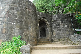
Shivneri Fort is a 17th-century military fortification located near Junnar in Pune district in Maharashtra, India. It is the birthplace of Shivaji, the emperor and founder of Maratha Empire.

Malshej Ghat

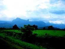
Malshej Ghat is a mountain pass located on Maharashtra's Kalyan–Ahmednagar Road in the Western Ghats range.

Giant Metrewave Radio Telescope

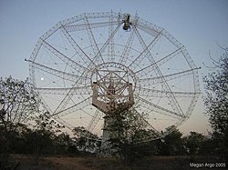
The Giant Metrewave Radio Telescope (GMRT), located near Pune, Junnar, near Narayangaon at khodad in India, is an array of thirty fully steerable parabolic radio telescopes of 45 metre diameter, observing at metre wavelengths. It is operated by the National Centre for Radio Astrophysics (NCRA), a part of the Tata Institute of Fundamental Research, Mumbai. It was conceived and built under the direction of Late Prof. Govind Swarup during 1984 to 1996. It is an interferometric array with baselines of up to 25 kilometres (16 mi). It was recently upgraded with new receivers, after which it is also known as the Upgraded Giant Metrewave Radio Telescope (uGMRT).

Narayangaon Town in Maharashtra, India

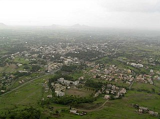
Narayangaon is a town in the Junnar taluka of the Pune district of Maharashtra state, India. Water is abundant because of its proximity to the major dams, the western ghats, and the Sahyadri mountain range.

National Centre for Radio Astrophysics

The National Centre for Radio Astrophysics (NCRA) of India is a research institution in India in the field of radio astronomy is located in the Pune University Campus, is part of the Tata Institute of Fundamental Research, Mumbai, India. NCRA has an active research program in many areas of Astronomy and Astrophysics, which includes studies of the Sun, Interplanetary scintillations, pulsars, the Interstellar medium, Active galaxies and cosmology and particularly in the specialized field of Radio Astronomy and Radio instrumentation. NCRA also provides exciting opportunities and challenges in engineering fields such as Analog and Digital Electronics, Signal Processing, Antenna Design, Communication and Software Development. NCRA has set up the Giant Metrewave Radio Telescope (GMRT), the world's largest telescope operating at meter wavelengths located at Khodad, 80 km from Pune. NCRA also operates the Ooty Radio Telescope (ORT), which is a large Cylindrical Telescope located near Udhagamandalam, India.

Junnar City in Maharashtra, India

Junnar is a city in the Pune district of the Indian state of Maharashtra. The city has history dating back to the first millennium. The nearby fort of Shivneri was the birthplace of Maratha king Chatrapati Shivaji Maharaj, the founder of the Maratha Empire. Junnar was declared the first tourism taluka in Pune district by the government of Maharashtra on 9 January 2018.

Pune district District of Maharashtra in India

Pune district is the most populous district in the Indian state of Maharashtra. The district's population was 9,429,408 in the 2011 census, making it the fourth most populous district amongst India's 640 districts. This district has an urban population of 58.08 percent of its total. It is one of the most industrialized districts in India. In recent decades it has also become a hub for information technology.

Shirur is an administrative subdivision of the Pune district in the Indian state of Maharashtra. It is located on the eastern boundary of the district, on the banks of the Ghod River. The town is also called Ghodnadi to distinguish it from other locations that have the same name. Ghodnadi in Marathi Language means Ghod River.

Shirur may refer to various places in India:

Chas Ghodegaon Small Town in Maharashtra, India

Chas is a small town on the banks of the river Ghod River in Ambegaon taluka of Pune district in the Indian state of Maharashtra, India.

Dhamankhel धामणखेल is a village situated at about 3 km from Junnar city of Pune district. There is a famous Dhamankhel kulaswami धामणखेल khandoba mandir at dhamankhel village धामणखेल. It is family deity of all village families in this village.

Narayangad is a fort in Pune district near to khodad-Gadachiwadi in the Indian state of Maharashtra.

Parner taluka Tehsil in Maharashtra, India

Parner taluka is a taluka in Ahmednagar district in the state of Maharashtra, India.

Junnar taluka Tehsil in Maharashtra, India

Junnar taluka is a taluka (subdivision) of the Pune district in the Indian state of Maharashtra. It is northernmost taluka of the District.The area is well known for two of the Ashtavinayak temples at Lenyadri and Ozar respectively. The taluka is also the home of Shivneri Fort, GMRT (Khodad), and Vikram Sarabhai Earth Station at Arvi. There is also a tomb(Samadhi) at Ale of the buffalo that recited Vedas when requested by the 12th century Sant Dnyaneshwar. The five main dams are named Yedgaon, Pimapalgaon Joga, ManikDoha, Chilhewadi and Wadaj. An ancient place called Naneghat is there. It is known for historical evidence that was written in Bramhi Lipi, on the walls of the caves. Darya Ghat is 21 km from Junnar Which is famous for waterfalls.Kukdeshwar an ancient temple of lord Shiva is in Junnar.

Pimpalner, is a small town in Parner Taluka in Ahmednagar district of state of Maharashtra, India. It belongs to Nashik Division. It is located 49 km to the west of District headquarters Ahmednagar. 12 km from Parner. 189 km from State capital Mumbai. Pimpalner is surrounded by Parner Taluka to the north, Ahmednagar Taluka to the east, Shrigonda Taluka to the south, Khed Taluka to the west. Shirur, Ahmednagar, Shrigonda, Manchar are the nearby cities to Pimpalner.

Ranjangaon Mashid is a village in Parner taluka in Ahmednagar district of state of Maharashtra, India.

Sherikasari is a newly separated small village from Alkuti village of Parner Taluka in Ahmednagar District of state of Maharashtra, India.

Chavand is a hill fortress situated 30 km from the modern-day town of Naryangoan in Junnar Taluka of Pune district in Maharashtra, India. The fort, which rises 1,036 meters above sea level, is located in the Sahyadri mountain range. The fort was looted and destroyed by the British upon siege. This is one of the forts known as the 'Famous 5'. Chavaand, Hadsar, Shivneri, Jivdhan and Naneghat form the Famous 5 trek. The fort has remnants of construction that are more than 800 years old. Village of Chavandwadi lies at the base of the fort. Under the rule of Shivaji, this was known as Prasannagad.

Kavathe is a village located in Shirur Taluka of the Pune district of Maharashtra state. The village adds the name of local hindu goddess 'Yemai' for distingushing from other villages in Maharashtra with similar name. Kavathe is known for it historical link with Maratha Empire and because of various folk art & artiste associated with Tamasha, drama, Jagaran-Gondhal and Bharud. Poet Bashir Momin Kavathekar and Dholak performer Shri Gangaram Bua are the two prominent folk artiste who had brought laurels with their notable contribution to the Maharashtra's performing art, culture and traditional art form Tamasha. Vithabai Bhau Mang Narayangaonkar's grandfather Shri Narayan Khude who formed his own Tamasha Troupe was also from Kavathe Yamai.

Nimgiri- Hanumantgad Fort is Located in Junnar taluka of Pune district in Maharashtra. These two forts jointly form two peaks on a same hill. It is one of the seven important forts along with Hadsar, Chavand, Shivneri, Jivdhan, Narayangad and Sindola forts that protected the trade route during medieval period from Junnar to Kalyan port through Naneghat. This is a fort located 25 km (16 mi) from the Junnar town.

References

  1. Navigation News | Frontline. Frontline.in.
  2. "Introducing GMRT".