
Rajgarh district is a district of Madhya Pradesh in central India. The city of Rajgarh is the administrative headquarters of the district. The old name of Rajgarh was Jhanjhanipur, and was ruled by the Bhils up to 1645. Rajgarh in Madhya Pradesh is one of the aspirational districts selected by Government of India. The district has an area of 6,154 km² and the population is 1,545,814. The district lies on the northern edge of the Malwa plateau, and the Parbati River forms the eastern boundary of the district, while the Kali Sindh River forms the western boundary. The district has seven tehsils, Rajgarh, Khilchipur, Jirapur, Biaora, Narsinghgarh, Sarangpur and Pachore. The district is bounded by Rajasthan state to the north, and by the districts of Guna to the northeast, Bhopal to the east, Sehore to the southeast, and Shajapur to the south and west. It is part of Bhopal Division. There are 1728 villages in Rajgarh.
Jhalawar district is one of the 33 districts of Rajasthan state in western India. The historical city of Jhalawar is the administrative headquarters of the Jhalawar district. The district is bounded on the northwest by Kota district, on the northeast by Baran district, on the east by Guna district of Madhya Pradesh state, on the south by Rajgarh district and Agar district of Madhya Pradesh state and on the west by Ratlam district and Mandsaur district of Madhya Pradesh state. The district occupies an area of 6219 km². The district is part of Kota division. To know more about Jhalawar City

Bhopal District is a district of Madhya Pradesh state in central India. The city of Bhopal serves as its administrative headquarters. The district is part of Bhopal Division.
Biaora is a city and municipality in Rajgarh district in the state of Madhya Pradesh, India. biaora is one of the six tehsils of rajgarh district.Biaora was originally ruled by the Bhil kings; the last Bhil king was Dhola Bhil. The primary languages spoken in biaora are Malvi, English and Hindi. It is situated on National Highway NH-3 and Jaipur National Highway.
Jirapur is a town and a nagar panchayat in Rajgarh district in the Indian state of Madhya Pradesh. In 2022 Janpad Panchayat election held across Madhya Pradesh, Congress won the election and secure position as a Janpad Adhyaksh under the leadership of Khilchipur vidhayak Shri Priyavrat Singh Ji. He put all the efforts to win this election and doing great work for Khilchipur constituency. He won 2018 assembly election of Madhya Pradesh with huge margin of 30,000+ votes by defeating Kunwar Hajarilal Dangi of Bharatiya Janata Party (BJP) candidate.
Mahroni is a town and a nagar panchayat in Lalitpur district in the Indian state of Uttar Pradesh. It is one of the tehsils of Lalitpur District, and is situated 37 km away from Laitpur. It is very close to Madhya Pradesh and Uttar Pradesh border.
Nowrozabad or Khodargama is a town and a Nagar Palika in Umaria district in the Indian state of Madhya Pradesh. Kendriya Vidyalaya Nowrozabad is situated in the G.M Complex Johila area. Nowrozabad is the head office of Johila area. The nearest Airport is at Jabalpur in Madhya pradesh. Nowrozabad Railway Station is on the Katni - Anuppur rail route. There are many coal mines around here. National Highway 43 has its route through Nowrozabad.
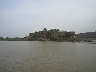
Sarangpur is a city and tehsil in Rajgarh district in the Indian state of Madhya Pradesh. It is situated at the bank of the river Kali Sindh.
Thandla is a town in Thandla Tehsil in Jhabua District of Madhya Pradesh, India. It belongs to Indore Division. It is located 30 km north of the District headquarters of Jhabua. It is a Tehsil headquarter. Thandla was named after Bhil Sardar Thana.

Vijayraghavgarh is a town, tehsil headquarters, and a nagar panchayat located in Katni district in the Indian state of Madhya Pradesh. It belongs to Jabalpur division and is 34 km (21 mi) east of district headquarters Katni.
Rudhmuli is a village in Bah Tehsil of Agra District of Uttar Pradesh in India.

Chachoura Assembly constituency is one of the 230 Vidhan Sabha constituencies of Madhya Pradesh state in central India. This constituency came into existence in 1951, as one of the 79 Vidhan Sabha constituencies of the erstwhile Madhya Bharat state.
Kachnariya is a village in the rajgarh district of Madhya Pradesh, India. It is located in thea biaora tehsil.
Amlabe is a village in the Jirapur Tehsil of Rajgarh District in the state of Madhya Pradesh in central India. The village population is approximately 1,850 residents and the number of households is around 465.
Zirapur tehsil is a tehsil in Rajgarh district, Madhya Pradesh, India. It is also a subdivision of the administrative and revenue division of bhopal district of Madhya Pradesh.
Biaora tehsil is a tehsil in Rajgarh district, Madhya Pradesh, India. It is also a subdivision of the administrative and revenue division of bhopal district of Madhya Pradesh.
Narsinghgarh tehsil is a tehsil in Rajgarh district, Madhya Pradesh, India. It is also a subdivision of the administrative and revenue division of bhopal district of Madhya Pradesh.
Sarangpur tehsil is a tehsil in Rajgarh district, Madhya Pradesh, India. It is also a subdivision of the administrative and revenue division of bhopal district of Madhya Pradesh.
Pachore tehsil is a tehsil in Rajgarh district, Madhya Pradesh, India. It is also a subdivision of the administrative and revenue division of bhopal district of Madhya Pradesh.
Suthaliya tehsil is a tehsil in Rajgarh district, Madhya Pradesh, India. It is also a subdivision of the administrative and revenue division of bhopal district of Madhya Pradesh.

