
Nikaia, known before 1940 as Kokkinia, is a town and a suburb of the Piraeus agglomeration, in the southwestern part of the Athens urban area, Greece. Since the 2011 local government reform it is part of the municipality Nikaia-Agios Ioannis Rentis in the regional unit of Piraeus, and it is the seat and a municipal unit of the municipality.

Palamas is a town and a municipality in the Karditsa regional unit, Greece. Palamas is located south-southwest of Larissa, the capital of Thessaly, northwest of Lamia, north of Sofades, east-northeast of Karditsa and east-southeast of Trikala. Palamas is linked with the road linking Karditsa and Larissa. It also serves roads with the GR-6 and Sofades. The Pineios River is to the north as well as the Trikala regional unit.

Makryneia is a former municipality in Aetolia-Acarnania, West Greece, Greece. Since the 2011 local government reform it is part of the municipality Agrinio, of which it is a municipal unit. The municipal unit has an area of 149.687 km2. The seat of the municipality was in Gavalou. The municipal unit is located south and southeast of Lake Trichonida, and northwest of the mountain Arakynthos. There are farmlands near the lake shore, and forests on the mountain slopes. Makryneia is southeast of Agrinio, northeast of Missolonghi and northwest of Naupactus.

Agia is a village and a municipality in the Larissa regional unit, Thessaly, Greece. Agia is located east of Larissa and south of Melivoia. The Mavrovouni mountains dominate the south and the Aegean Sea lies to the east.

Armenio is a village and a former municipality in the Larissa regional unit, Thessaly, Greece. Since the 2011 local government reform it is part of the municipality Kileler, of which it is a municipal unit. Population 1,701 (2021). The municipal unit has an area of 99.403 km2.

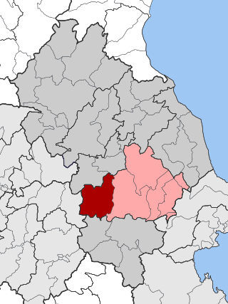
Gonnoi is a former municipality in the Larissa regional unit, Thessaly, Greece. Since the 2011 local government reform it is part of the municipality Tempi, of which it is a municipal unit. The municipal unit has an area of 113.333 km2. The municipality was created under the Kapodistrias Law in 1997 out of the former communes of Gonnoi, Kallipefki, Itea and Elaia. About 2 kilometres (1.2 mi) southeast of the town lies the site of the ancient city of Gonnus, after which the present town is named.

Koilada is a village and a former municipality in the Larissa regional unit, Thessaly, Greece. Since the 2011 local government reform it is part of the municipality Larissa, of which it is a municipal unit. Population 3,256 (2021). The municipal unit has an area of 162.299 km2.
Krannonas is a village and a former municipality in the Larissa regional unit, Thessaly, Greece. Since the 2011 local government reform it is part of the municipality Kileler, of which it is a municipal unit. It is located southwest of the regional capital Larissa. In 2021 its population was 127 for the community and 2,007 for the municipal unit. The municipal unit has an area of 205.242 km2. The seat of the municipality was Agioi Anargyroi. It is located north of Farsala and NNE of Palamas and Karditsa.

Livadi or Leivadi is a village and a former municipality in the Larissa regional unit, Thessaly, Greece. Since the 2011 local government reform it is part of the municipality Elassona, of which it is a municipal unit.
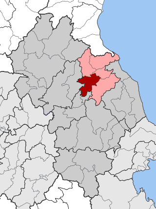
Makrychori is a former municipality in the Larissa regional unit, Thessaly, Greece. Since the 2011 local government reform it has been part of the municipality Tempi, of which it is a municipal unit. The municipal unit has an area of 107.767 km2. The municipality was created under the Kapodistrias Law in 1997 out of the former communes of Elateia, Evangelismos, Gyrtoni and Parapotamos.
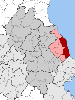
Melivoia is a town and a former municipality in the Larissa regional unit, Thessaly, Greece. Since the 2011 local government reform it is part of the municipality Agia, of which it is a municipal unit. The municipal unit has an area of 197.633 km2. The seat of the municipality was in Kato Sotiritsa. Melivoia is located east of Larissa, the capital of the regional unit and Thessaly, and a few kilometers north of Agia. The municipal unit stretches along the Aegean Sea coast, at the foot of Mount Ossa. It was named after the ancient city Meliboea. The municipal unit borders on Magnesia to the southeast.

Narthaki is a village and a former municipality in the Larissa regiona unit, Thessaly, Greece. Since the 2011 local government reform it is part of the municipality Farsala, of which it is a municipal unit. Population 989 (2021). The municipal unit has an area of 164.101 km2.

Nessonas is a village and a former municipality in the Larissa regional unit, Thessaly, Greece. Since the 2011 local government reform it is part of the municipality Tempi, of which it is a municipal unit. Population 3,945 (2021). The municipal unit has an area of 172.675 km2. The seat of the municipality was in Sykourio.

Nikaia is a town and a former municipality in the Larissa regional unit, Thessaly, Greece. Located 4 km south of Larissa city, it forms a part of Larissa's metropolitan area, that lies in the Thessalian plain. Since the 2011 local government reform, it has been part of the municipality Kileler, of which it is the seat and a municipal unit. The population is 5,436 (2021). The municipal unit has an area of 279.562 km2.

Olympos is a former municipality in the Larissa regional unit, Thessaly, Greece. Since the 2011 local government reform it is part of the municipality Elassona, of which it is a municipal unit. The municipal unit has an area of 303.964 km2. The seat of the municipality was in Kallithea. The municipality was named after the nation's highest point, Mount Olympus.

Platykampos is a village and a former municipality in the Larissa regional unit, Thessaly, Greece. Since the 2011 local government reform it is part of the municipality Kileler, of which it is a municipal unit. Population 7,207 (2021). The municipal unit has an area of 244.698 km2.

Sarantaporo is a village and a former municipality in the Larissa regional unit, Thessaly, Greece. Since the 2011 local government reform it is part of the municipality Elassona, of which it is a municipal unit. The municipal unit has an area of 150.902 km2, and the community has an area of 26.958 km2. The town is between the mountains of Kamvounia to the northwest and the Pierian Mountains to the northeast. The river Sarantaporos flows through the municipality. Sarantaporo is on the Greek National Road 3. It is located west-southwest of Katerini, northwest of Elassona and Larissa, east of Grevena and south-southeast of Kozani.

Karya is a village, a community and a municipal unit of the Elassona municipality. Before the 2011 local government reform it was an independent community. The community of Karya covers an area of 74.964 km2 while the municipal unit covers 158.685 km2.

Farkadona is a municipality in the southeastern Trikala regional unit, part of Thessaly in Greece. It is located about halfway between the cities Larissa to the east, and Trikala to the west, at about 30 km from both. It is situated in the Thessalian Plain, near the river Pineios. Farkadona is on the Greek National Road 6.

Nikaia-Agios Ioannis Renti is a municipality in the Piraeus regional unit, Attica, Greece. The seat of the municipality is the town Nikaia. The municipality has an area of 11.173 km2.


