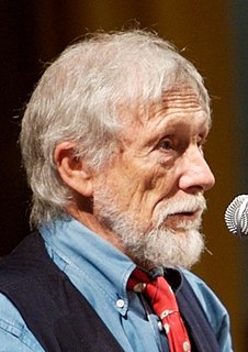
Gary Snyder is an American man of letters. Perhaps best known as a poet, he is also an essayist, lecturer, and environmental activist with anarchoprimitivist leanings. He has been described as the "poet laureate of Deep Ecology". Snyder is a winner of a Pulitzer Prize for Poetry and the American Book Award. His work, in his various roles, reflects an immersion in both Buddhist spirituality and nature. He has translated literature into English from ancient Chinese and modern Japanese. For many years, Snyder was an academic at the University of California, Davis and for a time served as a member of the California Arts Council.

King Lear is a tragedy written by William Shakespeare. It is based on the mythological Leir of Britain. King Lear, in preparation for his old age, divides his power and land to two of his daughters. He becomes destitute and insane and a proscribed crux of political machinations. The first known performance of any version of Shakespeare's play was on St. Stephen's Day in 1606. The three extant publications from which modern editors derive their texts are the 1608 quarto (Q1) and the 1619 quarto and the 1623 First Folio. The quarto versions differ significantly from the folio version.

The Dharma Bums is a 1958 novel by Beat Generation author Jack Kerouac. The basis for the novel's semi-fictional accounts are events occurring years after the events of On the Road. The main characters are the narrator Ray Smith, based on Kerouac, and Japhy Ryder, based on the poet and essayist Gary Snyder, who was instrumental in Kerouac's introduction to Buddhism in the mid-1950s.

Smarts Mountain is a 3,238-foot-high (987 m) mountain in the town of Lyme in Grafton County, New Hampshire, United States. Smarts is flanked to the north by Mount Cube, at 2,909 feet (887 m), and to the southwest by Holts Ledge, at 2,110 feet (640 m). Although of only moderate elevation, Smarts is separated from the southwestern White Mountains by Oliverian Notch, a fairly low pass traversed by New Hampshire Route 25 southwest of Mount Moosilauke. That gives Smarts a relative height of 2,190 ft (670 m), which makes it one of twelve mountains in New Hampshire with a prominence over 2,000 ft (610 m).

Mountains and Rivers Without End is an epic poem by American poet and essayist Gary Snyder. Snyder began writing the thirty-nine poems contained in the epic in 1956 and published the final version in 1996. The work is divided into four parts, each exploring a different theme.
The Jackson Mountains are a north-northeast trending mountain range in southwestern Humboldt County, Nevada. The range is flanked on the west by the Black Rock Desert and the Black Rock Range beyond. To the north across the Quinn River and Nevada State Route 140 lie the Bilk Creek Mountains. To the northeast across Kings River Valley is the Double Mountains and to the east are the Sleeping Hills. To the southeast and south lie the Eugene and Kamma Mountains. The ghost town of Sulphur lies just southwest of the pass between the Jackson and Kamma ranges. Nevada State Route 49 and the Union Pacific railroad Feather River Route traverse this pass.
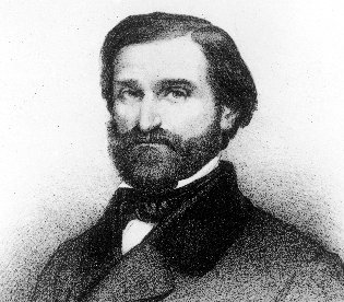
Re Lear is an Italian operatic libretto in four acts written by Antonio Somma for the Italian opera composer Giuseppe Verdi. It was based on King Lear, "the Shakespeare play with which Verdi struggled for so many years, but without success".
Mountains and Rivers Without End is a 1996 epic poem by American poet Gary Snyder.
Table Top Mountain is a mountain located in Essex County in the U.S. State of New York. Table Top Mtn. is flanked to the north by Phelps Mountain, and to the south by Mount Marcy. Table Top has three summits; the southernmost is the highest, followed by the middle peak at 4,308 ft (1,313 m) and the north peak at 4,216 ft (1,285 m).

Santanoni Peak is a mountain located in Essex County, New York. The mountain is part of the Santanoni Mountains of the Adirondacks. The mountain's name is believed to be an Abenaki derivative of "Saint Anthony"; the first French fur traders and missionaries having named the area for Saint Anthony of Padua. Santanoni Peak is flanked to the north by Panther Peak, and to the southwest by Little Santanoni Mountain.
MacNaughton Mountain is a mountain located in Essex County, New York, named after James MacNaughton (1851–1905), the grandson of Archibald McIntyre. The mountain is part of the Street Range of the Adirondack Mountains.
Nye Mountain is a mountain located in Essex County, New York, named after William B. Nye (c.1815–1893), an Adirondack mountain guide. Nye Mountain is part of the Street Range of the Adirondack Mountains; it is flanked to the southwest by Street Mountain.

The Oxford Shakespeare is the range of editions of William Shakespeare's works produced by Oxford University Press. The Oxford Shakespeare is produced under the general editorship of Stanley Wells and Gary Taylor.

I Couldn't Live Without Your Love is a Petula Clark album released in the United States and the UK in September 1966. Clark's fifth US album release, I Couldn't Live Without Your Love was the first Petula Clark album to include creative personnel besides Tony Hatch, who produced the album and arranged some of the tracks, along with Johnny Harris.

Sacajawea Peak is a peak in the Wallowa Mountains, in the U.S. state of Oregon. It is in the Eagle Cap Wilderness and the Wallowa–Whitman National Forest.

Cordelia is a fictional character in William Shakespeare's tragic play King Lear. Cordelia is the youngest of King Lear's three daughters, and his favourite. After her elderly father offers her the opportunity to profess her love to him in return for one third of the land in his kingdom, she refuses and is banished for the majority of the play.

Dooby Lane is a folk art installation located near Gerlach, Nevada in the Black Rock Desert. Dooby Lane consists of a series of art installations that include aphorisms and the names of local residents carved in to stones. Larger installations such as "Ground Zero", Elvis, Imagination Station – Desert Broadcasting System are also present.

Mount Garfield is a 13,074-foot-elevation mountain summit located in San Juan County, Colorado, United States. It is situated eight miles south of the community of Silverton, in the Weminuche Wilderness, on land managed by San Juan National Forest. It is part of the San Juan Mountains range which is a subset of the Rocky Mountains of North America. Precipitation runoff from the mountain drains into tributaries of the Animas River. The peak can be seen from U.S. Route 550 and the Durango and Silverton Narrow Gauge Railroad. Topographic relief is significant as the west aspect rises over 4,300 feet (1,310 meters) above the river and railway in approximately one mile. It is set six miles west of the Continental Divide, one mile west of Electric Peak, and three miles east-southeast of Snowdon Peak.

Snowdon Peak is a 13,077-foot-elevation mountain summit located in San Juan County, Colorado, United States. It is situated seven miles south of the community of Silverton, in the Weminuche Wilderness, on land managed by San Juan National Forest. It is part of the San Juan Mountains range which is a subset of the Rocky Mountains of North America, and is set nine miles west of the Continental Divide. Topographic relief is significant as the east aspect rises 4,300 feet (1,310 meters) above the Animas River in approximately 1.5 mile. Neighbors include Mount Garfield three miles to the east-southeast, and Twilight Peak, which is the nearest higher peak, 3.7 miles to the south-southwest. This mountain can be seen from U.S. Route 550. The mountain is named after Snowdon, the highest mountain in Wales.

Electric Peak is a 13,292-foot-elevation mountain summit located in San Juan County, Colorado, United States. It is situated eight miles south of the community of Silverton, in the Weminuche Wilderness, on land managed by San Juan National Forest. It is part of the Needle Mountains which are a subset of the San Juan Mountains, which in turn is a subset of the Rocky Mountains. Precipitation runoff from the mountain drains into tributaries of the Animas River. The peak can be seen from U.S. Route 550 and the Durango and Silverton Narrow Gauge Railroad. Topographic relief is significant as the west aspect rises over 4,500 feet (1,370 meters) above the river and railway in approximately two miles. It is set five miles west of the Continental Divide, and one mile east of Mount Garfield. The mountain's name, which has been officially adopted by the United States Board on Geographic Names, was in use before 1906 when Henry Gannett published it in the Gazetteer of Colorado.

