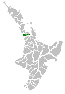
Franklin District was a New Zealand territorial authority that lay between the Auckland metropolitan area and the Waikato Plains. As a formal territory it was abolished on 31 October 2010 and divided between Auckland Council in the Auckland Region to the north and Waikato and Hauraki districts in the Waikato region to the south and east. The Auckland portion is now part of the Franklin ward, which also includes rural parts of the former Manukau City.

Pukekohe is a town in the Auckland Region of the North Island of New Zealand. Located at the southern edge of the Auckland Region, it is in South Auckland, between the southern shore of the Manukau Harbour and the mouth of the Waikato River. The hills of Pukekohe and nearby Bombay Hills form the natural southern limit of the Auckland region. Pukekohe is located within the political boundaries of the Auckland Council, following the abolition of the Franklin District Council on 1 November 2010.

Drury is a rural town near Auckland, in northern New Zealand. Located 36 kilometres to the south of Auckland CBD, under authority of the Auckland Council. Drury lies at the southern border of the Auckland metropolitan area, 12 kilometres to the northeast of Pukekohe, close to the Papakura Channel, an arm of the Manukau Harbour.
Ruatoria is a town in the Waiapu Valley of the Gisborne Region in the northeastern corner of New Zealand's North Island. The town was originally known as Cross Roads then Manutahi and was later named Ruatorea in 1913, after the Māori Master female grower Tōrea who had some of the finest storage pits in her Iwi at the time. In 1925 the name was altered to "Ruatoria", although some texts retain the original spelling.

Port Waikato is on the south bank of the Waikato River at its outflow into the Tasman Sea, in northern New Zealand.
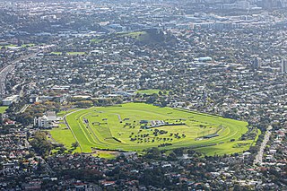
Ellerslie Racecourse is the main racecourse in Auckland, New Zealand, for thoroughbred racehorses. It is an undulating, grass circuit in the suburb of Ellerslie, with a circumference of just under 1,900 metres. Racing is conducted in a clockwise (right-handed) direction.
Rosehill College is a New Zealand co-educational state secondary school located in the Rosehill area of Papakura in the Auckland region. The college opened on 3 February 1970, and is now the largest secondary school in the area.

Pahurehure is a suburb of Auckland, in northern New Zealand. It is located on the south-eastern shores of the Manukau Harbour, under the authority of the Auckland Council. The suburb makes up the southernmost part of the Auckland urban area.

Karaka is a small rural area in the south of Auckland, New Zealand. Formerly part of Franklin District and under the authority of the Franklin District Council, it is now part of Auckland Council following the amalgamation of the Auckland region's councils.

Newmachar is a village in Aberdeenshire, Scotland about 10 miles (16 km) to the north-west of Aberdeen.
Te Karaka is a small settlement inland from Gisborne, in the northeast of New Zealand's North Island. It is located in the valley of the Waipaoa River close to its junction with its tributary, the Waihora River. Te Karaka is located on State Highway 2, and is the largest settlement between Gisborne and Opotiki in the Bay of Plenty.
Hingaia is a rural coastal suburb of Auckland, New Zealand. It is located on the shores of the Pahurehure Inlet, to the southwest of the Papakura Town Centre.

Taylors Hill, is a volcano in the Auckland volcanic field. It erupted about 33,000 years ago. Its scoria cone reaches 56 m high.

Kingseat Hospital was a psychiatric hospital that is considered to be one of New Zealand's notorious haunted locations with over one hundred claims of apparitions being reported, as of 2011. It is located in Karaka, New Zealand, south of Auckland and since 2005 has been used as a site for Spookers; and since 2013 a site for Asylum Paintball and Laser Combat; three New Zealand attractions. Spookers is believed to be Australasia's only haunted attraction scream park as of 2011, and "the number 1 Haunted Attraction in the Southern Hemisphere". According to stuff.co.nz, Kingseat Hospital is considered one of the most haunted locations in New Zealand.

Crofton Downs is an inner suburb of Wellington, the capital city of New Zealand. It is situated between Ngaio to the northeast Wilton to the south-west and Wadestown to the south. Its border runs on the Korimako Stream that flows south into the Kaiwharawhara Stream and then flows down the Ngaio Gorge into Wellington Harbour.
Paerata railway station was a flag station, 28 mi (45 km) south of Auckland, on the North Island Main Trunk in New Zealand, serving the Paerata settlement.

Karaka Bays is a suburb of Wellington, New Zealand. It lies on the northeast coast of the Miramar Peninsula, 6 km east-south-east of the city centre, and has an expansive view of Wellington Harbour. It takes its name from a New Zealand native tree, the karaka or New Zealand laurel.

Maupuia on the Miramar Peninsula is an eastern suburb of Wellington to the north-west of Miramar. Developed in the 1970s, it is in the Eastern Ward.

Kingseat is a village in Aberdeenshire, Scotland about 10 miles (16 km) to the north-west of Aberdeen and 1 mile (1.6 km) east of Newmachar.
Patumahoe or Patumāhoe is a small town of Auckland, New Zealand. It is in the Franklin Ward of Auckland Council.
