
Pukekohe is a town in the Auckland Region of the North Island of New Zealand. Located at the southern edge of the Auckland Region, it is in South Auckland, between the southern shore of the Manukau Harbour and the mouth of the Waikato River. The hills of Pukekohe and nearby Bombay Hills form the natural southern limit of the Auckland region. Pukekohe is located within the political boundaries of the Auckland Council, following the abolition of the Franklin District Council on 1 November 2010.
Puni is a rural locality in the Franklin Ward of Auckland in the North Island of New Zealand. It is predominantly a dairy farming and market gardening area. The main type of crops grown are potatoes, carrots, and onions.
Oranga is a small residential suburb in Auckland, New Zealand. It is located nine kilometres to the southeast of the city centre, between the commercial suburbs of Te Papapa and Penrose to the south and east, and the residential suburbs of One Tree Hill and Onehunga to the north and south.
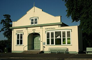
Kihikihi, a small town located in the Waikato region of the North Island of New Zealand, serves as a satellite community of Te Awamutu, five kilometres to the north, and lies 35 kilometres south of Hamilton. The 2018 New Zealand census recorded a population of 2,319 people The main reason for the large increase since 2013 is the construction of a large number of new dwellings.
Te Kauwhata is a small town in the north of the Waikato region of New Zealand, situated close to the western shore of Lake Waikare, some 40 km north of Hamilton.
Northcote is a suburb of Auckland in northern New Zealand. It is situated on the North Shore, on the northern shores of Waitematā Harbour, four km northwest of Auckland CBD. The suburb includes the peninsula of Northcote Point and the northern approaches to the Auckland Harbour Bridge. Northcote Central is to the north of Northcote.

Orakei is a suburb of Auckland city, in the North Island of New Zealand. It is located on a peninsula five kilometres to the east of the city centre, on the shore of the Waitematā Harbour, which lies to the north, and Hobson Bay and Orakei Basin, two arms of the Waitematā, which lie to the west and south. To the east is the suburb of Mission Bay. The mouth of the Waitematā is to the immediate north of Orakei, lying between Bastion Point, in Orakei, and North Head, in Devonport on the North Shore.
Clevedon, previously known as Wairoa South, is a rural town in Auckland, New Zealand, located in the Franklin ward, one of the thirteen administrative divisions of Auckland city. The town is governed by the Auckland Council. The town is the centre of an administrative ward of Franklin which takes in much of the largely rural area to the east of the urban heart of the city.

Wellsford is a town on the Northland Peninsula in the northern North Island of New Zealand. It is the northernmost major settlement in the Auckland Region, and is 77 kilometres northwest of the Auckland CBD.

Glen Innes is a suburb in East Auckland, New Zealand, located nine kilometres to the east of the city centre, close to the waters of the Tamaki River estuary.
Milford is a suburb of Auckland, New Zealand's largest city. It is located on Auckland's North Shore on the northern side of Lake Pupuke. It also has a popular swimming beach, which runs some two kilometers from Black Rock in the south to Castor Bay in the north. The Wairau Creek empties into the Hauraki Gulf at the northern end of Milford Beach, and its lower tidal reaches host the Milford Marina.

Mairangi Bay is a coastal suburb of North Shore, Auckland, located in the northern North Island of New Zealand, on the south-east-facing peninsula forming the northern side of the Waitematā Harbour. Mairangi Bay came under the local governance of the North Shore City Council until subsumed into the Auckland Council in 2010.
Birkdale is a suburb of Auckland, New Zealand, comprising statistical area units 'Birkdale North' and 'Birkdale South'. The suburb is located in the North Shore, and is under the governance of Auckland Council.
Balmoral is a suburb of Auckland, New Zealand that is bordered by Mount Eden, Epsom, Mount Roskill and Sandringham and is located approximately 5 km from the centre of Auckland. It was named around the turn of the 20th century and derives its name from Balmoral Castle, the Scottish country residence of the Royal family. Much of the housing in the area is from the 1920s and 1930s, often in the Californian Bungalow style. Balmoral was part of Mount Eden Borough Council which became a part of Auckland City in 1989. In November 2010, the area was included into the Albert-Eden-Roskill ward of the new Auckland Council.
Waimauku is a small locality in the Auckland Region of New Zealand. It comes under the jurisdiction of Auckland Council, and is in the council's Rodney ward. Waimauku is approximately 4 kilometres west of Huapai on State Highway 16 at the junction with the road to Muriwai Beach. Helensville is 16 km to the north-west. Waimauku is a Māori word which is literally translated as wai: stream and mauku: varieties of small ferns.
Alfriston is a small suburb of Auckland, New Zealand's largest city. Prior to November 2010 it was under the authority of the Papakura District Council and is now part of the enlarged Auckland city. The suburb is in the Manurewa-Papakura Ward, one of the thirteen administrative divisions of Auckland Council.
Ōpaheke is a suburb of Auckland, in northern New Zealand. It is located to the south of Papakura, and 32 kilometres south of Auckland CBD. The suburb makes up the southernmost part of the Auckland metropolitan area.
Papakura is a suburb of Auckland, in northern New Zealand. It is located on the shores of the Pahurehure Inlet, approximately 32 kilometres south of the Auckland CBD. It is under the authority of the Auckland Council.

Matakana is a small town in the Rodney Ward of Auckland Council of New Zealand. Warkworth lies about 9 km to the south-west, Snells Beach the same distance to the south, Omaha is about 7 km to the east, and Leigh about 13 km to the north-east. The Matakana River flows through the town and into Kawau Bay to the south-east.
Hunua is a small settlement in the rural outskirts of south Auckland, New Zealand.
