Kinkaid, Nevada

Last updated
Kinkaid, Nevada
USA Nevada location map.svg
Red pog.svg
Kinkaid
Usa edcp location map.svg
Red pog.svg
Kinkaid
Coordinates: Coordinates: 38°32′42″N118°23′41″W / 38.54500°N 118.39472°W / 38.54500; -118.39472 [1]
CountryUnited States
StateNevada
County Mineral
Elevation
[1]
4,409 ft (1,344 m)

Kinkaid is a populated place located in Mineral County. [1] . Kinkaid is also known as Kinkead and Kinkaid Siding. Kinkead was a stop on the Carson and Colorado Railway. Kinkead Mill, located in Kinkead, was in operation in the 1940s. [2] [3]
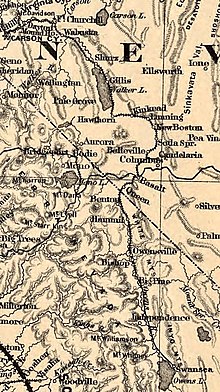
Carson and Colorado Railway route in 1883 showing Kinkead Carson & Colorado RR 1883.jpg
Carson and Colorado Railway route in 1883 showing Kinkead

Related Research Articles

Benewah County, Idaho U.S. county in Idaho

Benewah County is a county located in the northwest part of the U.S. state of Idaho. As of the 2010 United States Census the county had a population of 9,285. The county seat and largest city is St. Maries, which has some area inside the Coeur d'Alene Reservation.

Beaver Township, Bay County, Michigan Civil township in Michigan, United States

Beaver Township is a civil township of Bay County in the U.S. state of Michigan. The township's population was 2,885 as of the 2010 census. It is included in the Bay City Metropolitan Statistical Area.

Ray Township, Michigan Civil township in Michigan, United States

Ray Township is a civil township of Macomb County in the U.S. state of Michigan. As of the 2010 census, the township population was 3,739. Wolcott Mill Metropark, a 2,625 acres (10.62 km2) park is located entirely within the township. The park is named for and is home to an historic grist mill built in 1847.

Burrell Township, Armstrong County, Pennsylvania Township in Pennsylvania, United States

Burrell Township is a township in Armstrong County, Pennsylvania, United States and is part of the Pittsburgh metropolitan area. The population was 689 at the 2010 census.

Cowanshannock Township, Armstrong County, Pennsylvania Township in Pennsylvania, United States

Cowanshannock Township is a township in Armstrong County, Pennsylvania, United States. The population was 2,899 at the 2010 census.

Williston, Maryland Census-designated place in Maryland, United States

Williston is an unincorporated town and census-designated place on the Eastern Shore of the U.S. state of Maryland, in Caroline County. As of the 2010 census it had a population of 155. It is situated between Maryland Route 16 on its eastern edge and the Choptank River on its west. It was originally known as Potter's Landing for its first resident, Zabdiel Potter. His home, Potter Hall, was listed on the National Register of Historic Places in 1982.

Belleville, Nevada Unincorporated community & Ghost town in Nevada, United States

Belleville, Nevada, in Mineral County, Nevada, United States, was a mining town that rose up around the milling of ore shipped in from nearby mines. Today it is a ghost town.

Pleasant Mills, Indiana Unincorporated community in Indiana, United States

Pleasant Mills is an unincorporated community in St. Marys Township, Adams County, in the U.S. state of Indiana.

Dunn Mill, Indiana Unincorporated community in Indiana, United States

Dunn Mill is an unincorporated community in Lake Township, Allen County, in the U.S. state of Indiana.

Wagners, California Former settlement in California, United States

Wagners is a former settlement in Butte County, California. It was located 9 miles (14 km) north-northwest of Clipper Mills, at an elevation of 4101 feet. It appears on maps as of 1897.

Wooddale, Delaware Unincorporated community in Delaware, United States

Wooddale is an unincorporated community in New Castle County, Delaware, United States. Wooddale is located along the Red Clay Creek and Rolling Mill Road west of Wilmington.

White Mills, Pennsylvania Place in Pennsylvania, United States

White Mills is a village and census-designated place in Texas Township, Wayne County, Pennsylvania. The CDP's population was 659 at time of the 2010 United States Census.

Pancoastburg, Ohio Census-designated place in Ohio, United States

Pancoastburg is an unincorporated community and census-designated place (CDP) in Madison Township, Fayette County, Ohio, United States. It is located at 39°37′28″N83°15′56″W, along Ohio State Route 207, about 6 miles (10 km) south of Mount Sterling. As of the 2010 census the population of Pancoastburg was 87.

Crain, Illinois Unincorporated community in Illinois, United States

Crain is an unincorporated community in Kinkaid Township, Jackson County, Illinois, United States. Crain is located on Illinois Route 3, 9.5 miles (15.3 km) west of Murphysboro.

South Mills, North Carolina Census-designated place in North Carolina, United States

South Mills is an unincorporated community and census-designated place (CDP) in Camden County, North Carolina, United States. Its population was 454 as of the 2010 census. South Mills has a post office with ZIP code 27976, which opened on March 2, 1840. The community is located near U.S. Route 17, and U.S. Route 17 Business and North Carolina Highway 343 pass through the community.

Wyckoff Mills, New Jersey Unincorporated community in New Jersey, United States

Wyckoff Mills is an unincorporated community located within Howell Township in Monmouth County, New Jersey, United States. The settlement is centered about the intersection of Wyckoff Mills Road and Strickland Road, just east of U.S. Route 9 in the western sector of the township.

Monroe, Jackson County, Ohio Unincorporated community in Ohio, United States

Monroe is an unincorporated community in Jefferson Township, Jackson County, Ohio, United States. It is located southwest of Oak Hill on Ohio State Route 140 between Blackfork Junction and Firebrick, at 38°51′23″N82°37′45″W.

Mineral Hill, Nevada Ghost town in Nevada, United States

Mineral Hill is a ghost town in Eureka County, Nevada, US.

Oreana, Nevada Unincorporated community in Nevada, United States

Oreana is a ghost town in Pershing County, Nevada, United States.

References

  1. 1 2 3 U.S. Geological Survey Geographic Names Information System: Kinkaid
  2. U.S. Geological Survey Geographic Names Information System: Kinkead Mill
  3. "Plant at Kinkead operting on custom ore". Reno Gazette-Journal . June 28, 1941. Retrieved February 9, 2020.