Luning, Nevada

Last updated
Luning
Luning, Nevada.jpg
Full moon night at a school house in Luning
USA Nevada location map.svg
Red pog.svg
Luning
Location within the state of Nevada
Coordinates: 38°30′23″N118°10′53″W / 38.50639°N 118.18139°W / 38.50639; -118.18139 Coordinates: 38°30′23″N118°10′53″W / 38.50639°N 118.18139°W / 38.50639; -118.18139
Country United States
State Nevada
County Mineral
Founded1881;141 years ago (1881)
Named for Nicholas B. Luning
Time zone UTC-8 (PST)
  Summer (DST) UTC-7 (PDT)
ZIP codes
89420
Area code(s) 775

Luning (formerly Deep Wells) is an unincorporated town in Mineral County, Nevada, in the United States. Luning is located on U.S. Route 95, between Hawthorne and Mina. Luning had an active railroad loading facility for many years. Magnesium ore from Gabbs was trucked to Luning and transferred to railroad cars bound for the West in World War II. The Basic Refractories mine in Gabbs was opened in 1955; it produced magnesium that was also trucked to the Luning loading platform, where most men in town worked.

Contents

A sign on the Long Branch Saloon says "Settled 1864." The saloon - still open in 1980 - has since closed. The town's one-room school is well maintained, but is also closed. It is often listed as a ghost town, but it is not. The population of Luning, Nevada, as of 2005 is 87. There is also an active page for the "ghost" town on Facebook, maintained by residents.

The town once had a small store with attached gas station, a saloon, volunteer fire department station, and a post office. Except for the post office at 202 Plymire Street, all have since closed. The ZIP Code of Luning is 89420. Luning has two recent improvements: Cell phones and an improvement to their highway rest area.

Name

A station on the Southern Pacific Railroad between Thorne and Mina as a supply center for the Nevada Brucite quarry. Named for Nicholas B. Luning, a bondholder of the Carson and Colorado Railway. The town originally called Deep Wells started in 1881 and changed its name to Luning when the railroad arrived. [1] The post office opened in 1882. [2]

Buildings in Luning 2015-04-29 17 03 23 Buildings along U.S. Route 95 in Luning, Nevada.jpg
Buildings in Luning

Main Street

Luning's main street - Plymire Street - is named after a long-time resident, Dr. Fred A. Plymire.

Fred was a dentist, an inventor, and a stone man. Born in West Virginia in 1867, he traveled with his parents and five siblings to California where the family operated a marble monument company.

In 1894, Dr. Fred is listed in Stone, an illustrated magazine, in Notes from Quarry and Shop: “Fred Plymire, recently of Vallejo, and L. McCoy from Red Bluff, will establish marble works in Redding, Cal.” Fred is listed in the Official Catalogue of Exhibitors; Panama-Pacific International Exposition, San Francisco, 1915, Department of Mines and Metallurgy, State of Nevada, Group 153; Plymire, Dr. F. A., Mina. Polished marble. [3]

Dr Fred is listed in 1910 in the San Francisco Genealogy, Ancient and Accepted Scottish Rite List of Members. “California Bodies” Comprised California Lodge of Perfection, No. 10; California Chapter of Rose Crois, No. 7; California Council of Kadosh, No. 7; California Consistory, No. 5. [4] Dr. Fred holds a patent for an improved carburetor. [5]

After 20 years in Luning, Dr. Fred returned to California where he retired. He died in 1929 at Napa State Hospital in "general paralysis of insane." [6]

Climate

The Köppen Climate System classifies the weather in this area as semi-arid, abbreviated BSk. This climate type occurs primarily on the periphery of true deserts in low-latitude semiarid steppe regions. [7]

Climate data for Luning, Nevada
MonthJanFebMarAprMayJunJulAugSepOctNovDecYear
Average high °F (°C)47
(8)
53
(12)
62
(17)
68
(20)
77
(25)
86
(30)
96
(36)
94
(34)
85
(29)
72
(22)
57
(14)
48
(9)
70
(21)
Average low °F (°C)24
(−4)
28
(−2)
33
(1)
37
(3)
46
(8)
54
(12)
62
(17)
60
(16)
52
(11)
42
(6)
31
(−1)
25
(−4)
41
(5)
Average precipitation inches (mm)0.4
(10)
0.5
(13)
0.4
(10)
0.4
(10)
0.7
(18)
0.4
(10)
0.3
(7.6)
0.2
(5.1)
0.2
(5.1)
0.2
(5.1)
0.4
(10)
0.2
(5.1)
4.2
(110)
Source: Weatherbase [8]

Related Research Articles

South Lake Tahoe, California City in California, United States

South Lake Tahoe is the most populous city in El Dorado County, California, United States, in the Sierra Nevada. The city's population was 21,330 at the 2020 census, down from 21,403 at the 2010 census. The city, along the southern edge of Lake Tahoe, extends about 5 miles (8 km) west-southwest along U.S. Route 50, also known as Lake Tahoe Boulevard. The east end of the city, on the California–Nevada state line right next to the town of Stateline, Nevada, is mainly geared towards tourism, with T-shirt shops, restaurants, hotels, and Heavenly Mountain Resort with the Nevada casinos just across the state line in Stateline. The western end of town is mainly residential, and clusters around "The Y", the X-shaped intersection of US 50, State Route 89, and the continuation of Lake Tahoe Boulevard after it loses its federal highway designation.

Gardnerville, Nevada Unincorporated town in the State of Nevada, United States

Gardnerville is an unincorporated town in Douglas County, Nevada, adjacent to the county seat of Minden. The population was 6,211 at the time of the 2020 Census.

Gabbs, Nevada Unincorporated town in the State of Nevada, United States

Gabbs is an unincorporated town in Nye County, Nevada, United States. The population was 269 at the 2010 census and it is the northernmost community of Greater Las Vegas.

West Rutland, Vermont Town in Vermont, United States

West Rutland is a town in Rutland County, Vermont, United States. The population was 2,214 at the 2020 census. The town center, located in the south-central portion of the town and where about 87% of the population resides, is defined by the U.S. Census Bureau as a census-designated place (CDP). The town is part of the Rutland micropolitan NECTA.

Periclase Rocksalt, magnesium oxide mineral

Periclase is a magnesium mineral that occurs naturally in contact metamorphic rocks and is a major component of most basic refractory bricks. It is a cubic form of magnesium oxide (MgO). In nature it usually forms a solid solution with wüstite (FeO) and is then referred to as ferropericlase or magnesiowüstite.

Coloma, California Census-designated place in California, United States

Coloma is a census-designated place in El Dorado County, California, US. It is approximately 36 miles (58 km) northeast of Sacramento, California. Coloma is most noted for being the site where James W. Marshall found gold in the Sierra Nevada foothills, at Sutter's Mill on January 24, 1848, leading to the California Gold Rush. Coloma's population is 529.

Nipton, California Unincorporated community in California, United States

Nipton is an unincorporated community in the Ivanpah Valley in San Bernardino County, California. With a population of about 15 – 20, it is located on the northeastern border of Mojave National Preserve, approximately 12 miles (19 km) southeast of Primm, Nevada and the Ivanpah Solar Power Facility. It is accessible via Nevada State Route 164.

Montague, Texas Census-designated place & Unincorporated Community in Texas, United States

Montague is a census-designated place and unincorporated community in Montague County, Texas, United States. It is the county seat of Montague County and had an estimated population of 400 in 2000, according to the Handbook of Texas. Its population was 304 as of the 2010 census.

Genoa, Nevada Unincorporated town in the State of Nevada, United States

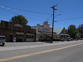
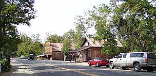
Genoa is an unincorporated town in Douglas County, Nevada, United States. Founded in 1851, it was the first settlement in what became the Nevada Territory. It is situated within Carson River Valley and is approximately 42 miles (68 km) south of Reno. The population was 939 at the 2010 census. It is home to the oldest bar in the state of Nevada which opened in 1853.

Midland is an unincorporated community in Klamath County, Oregon, United States, about 8 miles (13 km) south of Klamath Falls on U.S. Route 97. The site was platted in 1908 and named Midland, with a post office established in 1909. At the time it was said the name was chosen because the town was halfway between Portland and San Francisco on the proposed Cascade Line of the Southern Pacific Railroad. It is not halfway, however, and it is now thought that the name refers to the town's site on land partly surrounded by marshes.

Mina, Nevada Census-designated place in Nevada, United States

Mina is a census-designated place in Mineral County in west-central Nevada, United States. It is located along U.S. Route 95 at an elevation of 4,560 feet (1,390 m). The 2010 population was 155.

Oro Grande is an unincorporated community in the Mojave Desert of San Bernardino County, California, United States. It lies on the city boundary of Victorville and Adelanto. It is at 3,000 feet (910 m) elevation in Victor Valley north of the San Bernardino mountain range. It is located on old Route 66 near Interstate 15 between Victorville and Barstow. The ZIP code is 92368 and the community is inside area codes 442 and 760. Less than 1,000 residents live in the unincorporated area.

Cisco, Utah Ghost town in Utah, United States

Cisco is a ghost town in Grand County, Utah, United States near the junction of State Route 128 (SR‑128) and Interstate 70 (I‑70).

Emigrant Gap, California Unincorporated community in California, United States

Emigrant Gap is an unincorporated community in Placer County, California. The Emigrant Gap community is located 0.25 miles (0.4 km) southwest of the Emigrant Gap landmark. It lies at an elevation of 5190 feet.

Dyer, Nevada Census-designated place in Nevada, United States

Dyer is an unincorporated town, located in Fish Lake Valley, Esmeralda County, Nevada, United States. It had a population of 324 as of the 2018 American Community Survey. The town serves the surrounding area's sparse rural population of mainly ranchers and indigenous Paiute people. The town has a gas station/store, cafe, post office and airport.

Wabuska, Nevada Unincorporated community in the state of Nevada, United States

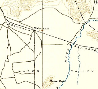
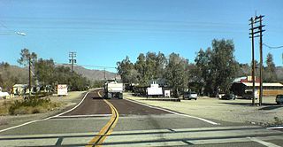
Wabuska is an unincorporated community in Lyon County, Nevada, United States. The zip code is 89447, which it shares with nearby Yerington.

Norden is a small unincorporated community in Nevada County, California, United States, about 9 miles (14 km) west of Truckee. The community is located on a former portion of U.S. Route 40 near Interstate 80 and lies along the historical First Transcontinental Railroad, 1.5 miles (2.4 km) west of Donner Pass.

Arminto, Wyoming Unincorporated community in Wyoming, United States

Arminto is an unincorporated community in northwestern Natrona County, Wyoming, United States. It lies along local roads west of the city of Casper, the county seat of Natrona County. Its elevation is 6,053 feet (1,845 m).

Madeline is an unincorporated town in Lassen County, California. It is located 45 miles (72 km) north-northeast of Susanville, at an elevation of 5321 feet. Its population is 21 as of the 2020 census.

Buffalo is an unincorporated community in Fergus County, Montana, United States. Buffalo has a post office with the ZIP code 59418. It was named for the buffalo which roamed this area.

References

  1. Carlson, Helen S. (1985). Nevada place names : a geographical dictionary. Reno: University of Nevada Press. p. 159. ISBN   0-87417-094-X.[ need quotation to verify ]
  2. "Post Offices". Jim Forte Postal History. Retrieved 20 April 2018.
  3. "Official Catalogue of Exhibitors: Division of Exhibits". Division of Exhibits. 18 September 2017. Retrieved 18 September 2017 via Google Books.
  4. "Consistory". www.scottishritecalifornia.org. Retrieved 18 September 2017.
  5. "Carbureter" . Retrieved 18 September 2017.
  6. http://trees.ancestry.com/tree/899060/person/6042952421/photox/dd00a5f2-5127-4f21-b24f-69dbc351d415?src=search [ user-generated source ]
  7. "Luning, Nevada Köppen Climate Classification (Weatherbase)". Weatherbase. Retrieved 18 September 2017.
  8. "Weatherbase.com". Weatherbase. 2013. Retrieved September 8, 2013.