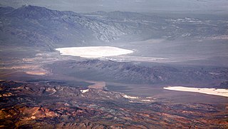
Groom Lake is a dry lake, also described as a salt flat, in Nevada. It is used for runways of the Nellis Bombing Range Test Site airport (KXTA). Part of the Area 51 USAF installation, it lies at an elevation of 4,409 ft (1,344 m) and is approximately 3.7 miles (6.0 km) from north to south and 3 miles (4.8 km) from east to west at its widest point, and is approximately 11.3 miles in circumference. Located within the namesake Groom Lake Valley portion of the Tonopah Basin, the lake is 25 mi (40 km) south of Rachel, Nevada.

The Pah Rah Range is a mountain range located in western Nevada in Washoe County just to the northeast of Reno. It is a hook shaped range with the main eastern portion oriented northwest–southeast, approximately 20 miles (32 km) long. The northwest flowing Cottonwood Creek in Warm Springs Valley is bounded on three sides by the range. To the south and east the Truckee River forms the boundary and Pyramid Lake is at the northeast. Spanish Springs Valley north of Reno forms the southwest margin. To the north, the narrow Mullen Pass separates the Pah Rah Range from the Virginia Mountains.

Silver Peak is an unincorporated community and census-designated place (CDP) in Esmeralda County, Nevada, United States. It lies along State Route 265, 20 miles (32 km) south of U.S. Route 6 and 30 miles (48 km) west of Goldfield, the county seat of Esmeralda County. It has a post office, with the ZIP code of 89047. The population of Silver Peak was 142 as of 2019.

Galena is an abandoned town in Washoe County, Nevada, south of Reno. The portion of Reno just south of Mount Rose Highway and west of Steamboat Springs is also known as Galena.
The pan amalgamation process is a method to extract silver from ore, using salt and copper(II) sulfate in addition to mercury. The process was widely used from 1609 through the 19th century; it is no longer used.

In the United States, gold mining has taken place continually since the discovery of gold at the Reed farm in North Carolina in 1799. The first documented occurrence of gold was in Virginia in 1782. Some minor gold production took place in North Carolina as early as 1793, but created no excitement. The discovery on the Reed farm in 1799 which was identified as gold in 1802 and subsequently mined marked the first commercial production.
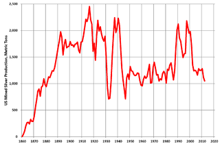
Silver mining in the United States began on a major scale with the discovery of the Comstock Lode in Nevada in 1858. The industry suffered greatly from the demonetization of silver in 1873 by the Coinage Act of 1873, known pejoratively as the "Crime of 73", but silver mining continues today.
Silver mining in Nevada, a state of the United States, began in 1858 with the discovery of the Comstock Lode, the first major silver-mining district in the United States. Nevada calls itself the "Silver State." Nevada is the nation's second-largest producer of silver, after Alaska. In 2014 Nevada produced 10.93 million troy ounces of silver, of which 6.74 million ounces were as a byproduct of the mining of gold. The largest byproducers were the Hycroft Mine, the Phoenix Mine, the Midas Mine and Round Mountain.

Castle Dome Landing, Arizona is a ghost town in the Castle Dome Mountains of Yuma County in the U.S. state of Arizona. It was first settled as a transport depot and mining camp around 1863 in what was then the Arizona Territory.
The Buena Vista Mine is located 21 miles (34 km) southeast of Lovelock, Nevada. In the past, the area has been known as the Mineral Basin, though another name for the area has been the Buena Vista District. There are at least two other Buena Vista Mining Districts in Nevada; one is located near Unionville, Nevada, and the other is located in Esmeralda and Mineral counties near the California border. The nearby Buena Vista Hills are named for the mine. The district encompasses roughly 21 square miles (54 km2) of mineral and surface rights, and is one of the largest un-mined iron ore resources in the western United States.
Roach is a ghost town and railroad siding in Clark County, Nevada, United States. It is located along the Union Pacific Railroad, between Jean, Nevada and Nipton, California.
Sodaville is an extinct town in Mineral County, in the U.S. state of Nevada. The GNIS classifies it as a populated place.

Lucky Boy is a ghost town in Mineral County, Nevada, approximately 5 mi (8.0 km) southwest of Hawthorne.
Thorne, Nevada is a rail junction and former town located in Mineral County, Nevada.
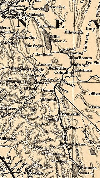
Basalt is a formerly populated place located in Mineral County, Nevada.
Rand is an extinct town in Mineral County, in the U.S. state of Nevada. The GNIS classifies Rand as a populated place with a "RR Locale" description. Rand was a station on the Carson and Colorado Railway.
Athens is a former mining settlement in Nye County, Nevada. It was established after a boom in 1910, but was deserted that same year. After the Warrior mine was founded, Athens revived and was inhabited until 1939, when the mining operations were ceased.
Eagleville is a former populated place in Mineral County, Nevada, that is now a ghost town.
Salt Wells, Nevada is the site of a former brothel and a possible future route of Interstate 11. Salt Wells is located on the northern edge of the Salt Wells Marsh, 15 miles southeast of Fallon, Nevada on U.S. Route 50 near Sand Mountain.


