
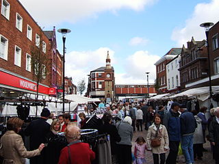
Kirkby is a town in the Metropolitan Borough of Knowsley, Merseyside, England. The town, historically in Lancashire, has a size of 4,070 acres (16.5 km2) is 5 miles (8 km) north of Huyton and 6 miles (10 km) north-east of Liverpool. The population in 2016 was 41,495 making it the largest in Knowsley and the 9th biggest settlement in Merseyside.

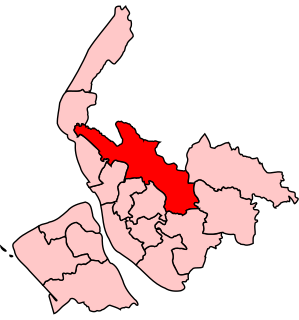
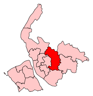
The Metropolitan Borough of Knowsley is a metropolitan borough in Merseyside, North West England. It covers several towns and villages, including Kirkby, Prescot, Huyton, Whiston, Halewood, Cronton and Stockbridge Village; Kirkby, Huyton, and Prescot being the major commercial centres. It takes its name from the village of Knowsley, though its headquarters are in Huyton. It forms part of the wider Liverpool City Region.
West Lancashire is a local government district with borough status in Lancashire, England. The council is based in Ormskirk, and the largest town in the borough is Skelmersdale. At the 2011 Census, the population of the borough was 110,685.
The Metropolitan Borough of St Helens is a local government district with borough status in Merseyside, North West England. The borough is named after its largest settlement, St Helens but also includes neighbouring towns and villages such as Earlestown, Rainhill, Eccleston, Clock Face, Haydock, Billinge, Rainford and Newton-le-Willows.
Whiston Rural District was a rural district of the administrative county of Lancashire, England. It was created in 1895 by renaming the Prescot Rural District when the parish of Prescot was removed from that rural district and created a separate urban district. Later the parish of Speke was incorporated into the City of Liverpool and Ditton into the Municipal Borough of Widnes. In 1922 the parish of Kirkby was added from the disbanded Sefton Rural District and removed again in 1958 when it was created a separate urban district. It was named after and administered from Whiston. In 1934 and 1954 parts of Windle and Eccleston were removed and placed in St Helens CB

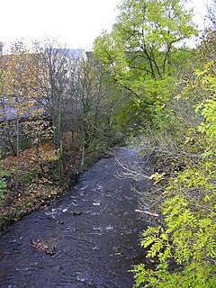
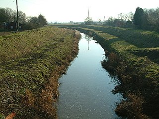
The River Alt is an urban river that flows across Merseyside in England. The river has suffered from heavy pollution from industry and sewage upstream and run-off from farmland in its lower reaches. It empties into the River Mersey, near to where the Mersey itself flows into the Irish Sea. The river has benefited from clean-up schemes and a de-culverting process to improve its water quality and provide a better environment for wildlife.
Knowsley North and Sefton East was a county constituency represented in the House of Commons of the Parliament of the United Kingdom. It elected one Member of Parliament (MP) by the first past the post system of election.
Knowsley North was a borough constituency represented in the House of Commons of the Parliament of the United Kingdom from 1983 until 1997. It elected one Member of Parliament (MP) by the first past the post voting system.
Knowsley is a constituency represented in the House of Commons of the UK Parliament since its 2010 creation by George Howarth of the Labour Party.
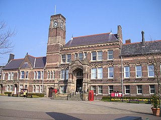
Knowsley Metropolitan Borough Council elections are generally held three years out of every four, with a third of the council being elected each time. Knowsley Metropolitan Borough Council, generally known as Knowsley Council, is the local authority for the metropolitan borough of Knowsley in Merseyside, England. Since the last boundary changes in 2016, 45 councillors have been elected from 15 wards.
West Lancashire was a rural district from 1894 to 1974 in Lancashire, England. It was created with other rural districts in 1894, based on the Ormskirk rural sanitary district. It was expanded in 1932 by the abolition of the Sefton Rural District.

The River Ogden is a minor river in Lancashire, England. It is approximately 4.4 miles (7.1 km) long and has a catchment area of 9.77 square miles (25.298 km2).
Colne Water is a river in eastern Lancashire. It is approximately 5.0 miles (7.987 km) long and has a catchment area excluding its major tributaries of 4.47 square miles (11.584 km2).
Prescot Urban District was a local government district in the administrative county of Lancashire, England from 1895 to 1974.the main settlement of the district was the town of Prescot.
Kirkby Urban District was a local government district in the administrative county of Lancashire, England, from 1958 to 1974. From 1949 onwards, the main settlement of the district was Kirkby new town. A District Council was created in 1958. The first meeting of the District Council was held on 9 April 1958. At that meeting it was resolved that Councillor James Wylie, J.P. be appointed Chairman of the Council

The Kirkby Project was a proposed new football stadium in Kirkby, England for Everton. The stadium, if built, would have replaced Goodison Park as Everton's home ground. The plan originated in 2006, was the subject of a Public Inquiry in December 2008, but was eventually rejected by central government in November 2009. The stadium had a planned all-seated capacity of 50,401 with a provision to be expanded to 60,000.

Knowsley United was an English football club based in the town of Huyton, Knowsley Merseyside. Originally named Kirkby Town they folded in 1997.
Downholland Brook is a 4.3-kilometre-long (2.7 mi) river (brook) in Merseyside, England, that is a tributary to the River Alt in the Alt catchment. Rising from Barton Brook in the Metropolitan Borough of Knowsley, the river flows a westerly course until reaching Moss Side, when it turns north towards Little Altcar in the Metropolitan Borough of Sefton. There, it flows into the River Alt.

Maghull Brook is a minor river (brook) in Merseyside, England, that is a tributary to the River Alt in the Alt catchment. Located entirely in the Metropolitan Borough of Sefton, Maghull Brook forms the boundary between the civil parishes of Maghull and Lydiate.

Simonswood Brook is a minor, 12-kilometre-long (7.5 mi) river (brook) in Merseyside, England, that is a tributary to the River Alt in the Alt catchment. As the stream enters Kirkby, it is known as the Kirkby Brook.
