Kishwaukee, Illinois | |
|---|---|
 Kishwaukee, Illinois  Kishwaukee, Illinois | |
| Coordinates: 42°09′54″N89°09′00″W / 42.16500°N 89.15000°W | |
| Country | United States |
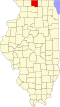
| State | Illinois |
| County | Winnebago |
| Elevation | 738 ft (225 m) |
| Time zone | UTC-6 (Central (CST)) |
| • Summer (DST) | UTC-5 (CDT) |
| Area codes | 815 & 779 |
| GNIS feature ID | 422882 [1] |
Kishwaukee is an unincorporated community in Winnebago County, in the U.S. state of Illinois. [1]