Related Research Articles
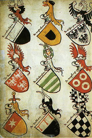
Heraldry is a discipline relating to the design, display and study of armorial bearings, as well as related disciplines, such as vexillology, together with the study of ceremony, rank and pedigree. Armory, the best-known branch of heraldry, concerns the design and transmission of the heraldic achievement. The achievement, or armorial bearings usually includes a coat of arms on a shield, helmet and crest, together with any accompanying devices, such as supporters, badges, heraldic banners and mottoes.
Anston is a civil parish in South Yorkshire, England, formally known as North and South Anston. The parish of Anston consists of the settlements of North Anston and South Anston, divided by the Anston Brook.

Huntingdon and Peterborough was a short-lived administrative and geographical county in East Anglia in the United Kingdom. It existed from 1965 to 1974, when it became part of Cambridgeshire.
In heraldry, variations of the field are any of a number of ways that a field may be covered with a pattern, rather than a flat tincture or a simple division of the field.
Ordinaries in heraldry are sometimes embellished with stripes of colour alongside them, have lumps added to them, shown with their edges arciform instead of straight, have their peaks and tops chopped off, pushed up and down out of the usual positions, or even broken apart.

Duke of Leeds was a title in the Peerage of England. It was created in 1694 for the prominent statesman Thomas Osborne, 1st Marquess of Carmarthen, who had been one of the Immortal Seven in the Revolution of 1688. He had already succeeded as 2nd Baronet, of Kiveton (1647) and been created Viscount Osborne, of Dunblane (1673), Baron Osborne, of Kiveton in the County of York and Viscount Latimer, of Danby in the County of York, Earl of Danby, in the County of York (1674), and Marquess of Carmarthen (1689). All these titles were in the Peerage of England, except for the viscountcy of Osborne, which was in the Peerage of Scotland. He resigned the latter title in favour of his son in 1673. The Earldom of Danby was a revival of the title held by his great-uncle, Henry Danvers, 1st Earl of Danby.

The Metropolitan Borough of Rotherham is a metropolitan borough of South Yorkshire, England. It is named after its main settlement of Rotherham. The wider borough spans a larger area and covers the outlying towns of Maltby, Swinton, Wath-upon-Dearne, Dinnington. As well as the villages of Rawmarsh and Laughton. A large valley spans the entire borough and is referred to as the "Rother Valley".

Woodsetts is a village and civil parish in the Metropolitan Borough of Rotherham in South Yorkshire, England, on the border with Nottinghamshire. It lies between the towns of Dinnington and Worksop at an elevation of around 60 metres above sea level, and has a population of 1,746 at the 2011 Census. The village originated as a medieval farming hamlet of the manor of Anston, nestled amongst the ancient woodland of which a few patches remain. The village grew rapidly in the late 19th century when a colliery was sunk at Dinnington. The village now serves as a commuter base for travellers between nearby towns.

Thorpe Salvin is a village and a civil parish in the Metropolitan Borough of Rotherham in South Yorkshire, England, on the border with Nottinghamshire. It lies between Worksop and Harthill, and is located at an elevation of around 110 metres above sea level. At the 2011 Census, it had a population of 476, down from 502 in 2001.
Kiveton Park is a village within the Metropolitan Borough of Rotherham, in South Yorkshire, England. Historically a part of the West Riding of Yorkshire, from the Norman conquest to 1868, Kiveton was a hamlet of the parish of Harthill-with-Woodall. It subsequently transferred to the civil parish of Wales which takes its name from the neighbouring village.
In heraldry, an ordinary is one of the two main types of charges, beside the mobile charges. An ordinary is a simple geometrical figure, bounded by straight lines and running from side to side or top to bottom of the shield. There are also some geometric charges known as subordinaries, which have been given lesser status by some heraldic writers, though most have been in use as long as the traditional ordinaries. Diminutives of ordinaries and some subordinaries are charges of the same shape, though thinner. Most of the ordinaries are theoretically said to occupy one-third of the shield; but this is rarely observed in practice, except when the ordinary is the only charge.

Uxbridge was a local government district in north west Middlesex, England, from 1849 to 1965, seated in the town of Uxbridge.
Hemsworth was, from 1894 to 1974, a rural district in the West Riding of Yorkshire, England.

The Municipal Borough of Richmond or Richmond Municipal Borough was a municipal borough in Surrey, England from 1890 to 1965.

Sale was, from 1867 to 1974, a district in Cheshire, England. The district had in turn the status of local government district, urban district and municipal borough. Its area now forms part of the Metropolitan Borough of Trafford, Greater Manchester.

The Coat of arms of Leeds City Council derives its design from the seventeenth century. In 1662 the Borough of Leeds received a new charter which created the office of mayor, and the arms seems to date from about this time as they incorporate part of the arms of the first mayor. These arms were recorded at the heraldic visitation of Yorkshire in 1666. By the time that the borough was reformed by the Municipal Corporations Act 1835, silver owls had been added both as crest above the shield, and as supporters on either side. These additions were not authorised, however, and in 1920 application was made by Leeds County Borough Council to the College of Arms to have these additions officially granted. In the following year the grant of crest and supporters was made, with the colouring of the owls altered to "proper", or natural colourings. Gold ducal coronets were added to the supporters for further heraldic difference.

Stockport County Borough was a county-level local authority between 1889 and 1974.
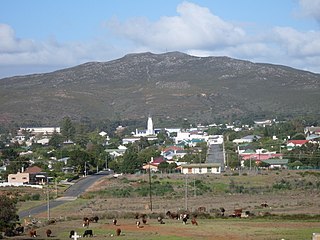
Bredasdorp is a town in the Southern Overberg region of the Western Cape, South Africa, and the main economic and service hub of that region. It lies on the northern edge of the Agulhas Plain, about 160 kilometres (100 mi) south-east of Cape Town and 35 kilometres (22 mi) north of Cape Agulhas, the southernmost tip of Africa.

George Godolphin Osborne, 8th Duke of Leeds was a British peer. He was known as Baron Godolphin from 1850 until 1859, when he inherited the dukedom.
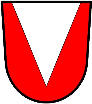
In heraldry, a pile is a charge usually counted as one of the ordinaries. It consists of a wedge emerging from the upper edge of the shield and converging to a point near the base. If it touches the base, it is blazoned throughout.
References
- ↑ F A Youngs Jr., Guide to the Local Administrative Units of England, Vol.II: Northern England, London, 1991
- ↑ "Kiveton Park RD". Vision of Britain. Archived from the original on 1 October 2007. Retrieved 29 June 2008.
- ↑ Geoffrey Briggs, Civic and Corporate Heraldry, London, 1971
- ↑ Sir Bernard Burke, A Genealogical and Heraldic Dictionary of the Peerage and Baronetage of the British Empire, London, 1865
- ↑ C Wilfrid Scott-Giles, Civic Heraldry of England and Wales, 2nd edition, London, 1953