Klamath Agency, Oregon

Last updated

Klamath Agency, Oregon
Klamath Indian Agency, Oregon (3229994806).jpg
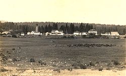
Klamath Indian Agency in 1915
USA Oregon location map.svg
Red pog.svg
Klamath Agency
Location within Oregon and the United States
Usa edcp location map.svg
Red pog.svg
Klamath Agency
Klamath Agency (the United States)
Coordinates: 42°37′05″N121°56′02″W / 42.61806°N 121.93389°W / 42.61806; -121.93389
Country United States
State Oregon
County Klamath
Elevation
[1]
4,180 ft (1,270 m)
Time zone UTC-8 (Pacific (PST))
  Summer (DST) UTC-7 (PDT)

Klamath Agency is an unincorporated community in Klamath County, Oregon, United States, [1] on Oregon Route 62 where Agency Creek enters Crooked Creek. [2]

Contents

Klamath Agency was an Indian agency for the Klamath Indian Reservation established May 12, 1866, on the shore of Agency Lake. [3] The current site of the former agency is 3 miles (5 km) north of that location. [3] The Klamath Reservation was terminated in 1961, but the community at Klamath Agency still exists. [3] Klamath Agency post office was established in 1878 and ran until 1965, when the mail was instead routed to Chiloquin. [3]

In 1870, there was a sawmill at the agency; it burned down in 1911. [4] In the 1890s, Klamath Agency was the site of two Indian boarding schools—one for boys and one for girls. [5]

In 1945, Ray Enouf Field was dedicated at the agency. The airfield was named in honor of the only Klamath Indian to die in World War II. [6] Raymond L. Enouf was a Marine private first class, who was killed while acting as a medic in the front lines during the Battle of Iwo Jima. [6]

The Klamath Agency is now home of the Sage Community Charter School.

See also

Related Research Articles

<span class="mw-page-title-main">Modoc Point</span>

Modoc Point is a cliff on the east shore of Upper Klamath Lake, in Klamath County, Oregon, United States, approximately 15 miles north of Klamath Falls on U.S. Route 97. It is part of the larger cliff known as Modoc Rim or Modoc Ridge.

<span class="mw-page-title-main">Bly, Oregon</span> Unincorporated community in the state of Oregon, United States

Bly is an unincorporated community in Klamath County, Oregon, United States. By highway, it is about 50 miles (80 km) east of Klamath Falls. As of 2020, the population was 207.

Midland is an unincorporated community in Klamath County, Oregon, United States, about 8 miles (13 km) south of Klamath Falls on U.S. Route 97. The site was platted in 1908 and named Midland, with a post office established in 1909. At the time it was said the name was chosen because the town was halfway between Portland and San Francisco on the proposed Cascade Line of the Southern Pacific Railroad. It is not halfway, however, and it is now thought that the name refers to the town's site on land partly surrounded by marshes.

Beatty is an unincorporated community and census-designated place (CDP) in Klamath County, Oregon, United States. Beatty is along Oregon Route 140 at the confluence of the Sycan and Sprague rivers and is 40 miles (64 km) by highway northeast of Klamath Falls.

Sprague River is an unincorporated community in Klamath County, Oregon, United States. It is about 45 miles (72 km) northeast of Klamath Falls near the Sprague River, northwest of Oregon Route 140.

<span class="mw-page-title-main">Drewsey, Oregon</span> Unincorporated community in the state of Oregon, United States

Drewsey is an unincorporated community in Harney County, in the U.S. state of Oregon. Drewsey is along the main stem of the Malheur River, about 45 miles (72 km) east of Burns, off U.S. Route 20. It has the ZIP Code of 97904.

<span class="mw-page-title-main">Umatilla River</span> River in Oregon, United States

The Umatilla River is an 89-mile (143 km) tributary of the Columbia River in northern Umatilla County, Oregon, United States. Draining a basin of 2,450 square miles (6,300 km2), it enters the Columbia near the city of Umatilla in the northeastern part of the state. In downstream order, beginning at the headwaters, major tributaries of the Umatilla River are the North Fork Umatilla River and the South Fork Umatilla River, then Meacham, McKay, Birch, and Butter creeks.

<span class="mw-page-title-main">Keno, Oregon</span> Unincorporated community in the state of Oregon, United States

Keno is an unincorporated community in Klamath County, Oregon, United States, southwest of Klamath Falls on the Klamath River near Oregon Route 66. As of 2000, the population was 1,059. Keno's elevation is 4,108 feet (1,252 m) above sea level.

<span class="mw-page-title-main">Tumalo, Oregon</span> Unincorporated community in the state of Oregon, United States

Tumalo is an unincorporated community and census-designated place (CDP) in Deschutes County, Oregon, United States. As of the 2010 census it had a population of 488. In the Klamath language, tumolo means "wild plum," a plentiful shrub in south central Oregon. Tumola means "ground fog," which may have described Tumalo Creek. Tumallowa, the original name of Tumalo Creek, means "icy water."

Illahe is an unincorporated community and the site of a former post office in Curry County, Oregon, United States. Located along the Rogue River about 8 miles (13 km) upriver from Agness, the area was home to Takelma Indians, then to white and Karok settlers, before becoming part of a designated wilderness. In the 21st century, it is a stopping place for hikers, boaters, and other visitors. The area has a riverside lodge and a nearby campground, both named Illahe.

<span class="mw-page-title-main">Stone Bridge and the Oregon Central Military Wagon Road</span> United States historic place

The Stone Bridge is a causeway built by the United States Army in 1867. It crosses the marshy channel that connects Hart Lake and Crump Lake in a remote area of Lake County in eastern Oregon, United States. It was later incorporated into the Oregon Central Military Wagon Road which was completed in 1872. The wagon road eventually became the subject of scandal and litigation ending with a United States Supreme Court decision in 1893. The Stone Bridge and the Oregon Central Military Wagon Road were listed together on the National Register of Historic Places in 1974. Today, the Stone Bridge is located on land claimed by the State of Oregon under riparian rights. The wagon road adjacent to the Stone Bridge is owned by the United States Government and is administered by Bureau of Land Management.

Modoc Point is an unincorporated community in Klamath County, Oregon, United States on U.S. Route 97 on the shore of Upper Klamath Lake.

Pinehurst is an unincorporated community in Jackson County, Oregon, United States, on Oregon Route 66 about 25 miles (40 km) southeast of Ashland. It is along Jenny Creek near Round Prairie between the Siskiyou Mountains and the foothills of the Cascade Range.

<span class="mw-page-title-main">Goose Lake Valley</span> Valley in south-central Oregon and northeastern California

The Goose Lake Valley is located in south-central Oregon and northeastern California in the United States. It is a high valley at the northwestern corner of North America's Great Basin. Much of the valley floor is covered by Goose Lake, a large endorheic lake that straddles the Oregon–California border. Native Americans inhabited the Goose Lake Valley for thousands of years before explorers arrived in the 19th century. The pioneer wagon route known as the Applegate Trail crossed the Goose Lake Valley on its way to southern Oregon. At the south end of Goose Lake, the Lassen Cutoff separated from the Applegate Trail and headed south toward the Sacramento Valley. Today, Lakeview, Oregon, is the largest settlement in the valley. Livestock ranching and lumber mills are the valley's main commercial activity. The Goose Lake Valley offers a number of recreational opportunities including hang-gliding, hunting, fishing, and birdwatching.

Leland is an unincorporated community in Josephine County, Oregon, United States. It lies in the Klamath Mountains along Grave Creek, a tributary of the Rogue River.

Odessa is an unincorporated community in Klamath County, Oregon, United States. Odessa is along Oregon Route 140 south of Rocky Point and about 25 miles (40 km) northwest of Klamath Falls. Odessa lies along the western shore of Upper Klamath Lake near the Fremont–Winema National Forest.

Olene is an unincorporated community in Klamath County, Oregon, United States. It is 10 miles (16 km) southeast of Klamath Falls on Oregon Route 140. Olene currently has a general store and at one time it had a school. In 1940 Olene had a population of 62 and was considered a suburb of Klamath Falls. Olene was the center of a prosperous dairy and potato farming district.

<span class="mw-page-title-main">Charles S. Drew</span> Union Army officer

Charles Stewart Drew, also known as C.S. Drew, was a representative in the legislature of the Oregon Territory of the United States and quartermaster general of the territorial militia in the 1850s. During the American Civil War, he was a Union Army officer, serving in the 1st Oregon Cavalry regiment. He eventually reached the rank of lieutenant colonel. In 1864, he led an Army reconnaissance party into southeastern Oregon. The expedition, known as the Owyhee Reconnaissance, traveled through uncharted country from Fort Klamath to Fort Boise and back. Drew was the author of two historically important military reports; one documented Indian attacks on American settlers in the Oregon Territory and the other was his report of the Owyhee Reconnaissance.

Henley is an unincorporated community in Klamath County, Oregon, United States. It is about 4 miles (6 km) southeast of Klamath Falls along Oregon Route 39.

Yonna is an unincorporated community in Klamath County, Oregon, United States. It lies east of Oregon Route 140 in Yonna Valley, northeast of Dairy and near the base of Short Lake Mountain.

References

  1. 1 2 "Klamath Agency". Geographic Names Information System. United States Geological Survey. November 28, 1980. Retrieved August 30, 2013.
  2. Oregon Atlas & Gazetteer (1st ed.). Freeport, Maine: DeLorme. 1991. p. 30. ISBN   0-89933-235-8.
  3. 1 2 3 4 McArthur, Lewis A.; McArthur, Lewis L. (2003) [1928]. Oregon Geographic Names (7th ed.). Portland, Oregon: Oregon Historical Society Press. pp. 540–541. ISBN   978-0875952772.
  4. Most, Steven (2003). "Subtopic : Putting Nature to Work: Running the Mill" . Retrieved January 10, 2010.
  5. "J. O. Lewis Photographs, PC 124". J. O. Lewis Collection of Photographs of Native American Schools, ca. 1895-1900. Washington State University . Retrieved January 10, 2010.
  6. 1 2 "Indians in the War: 1945". United States Navy Historical Center. Archived from the original on April 7, 2010. Retrieved January 10, 2010.